Beauplan, Guillaume Le Vasseur, sieur de, approximately 1600- cartographer.
Published / Created:
166-?]
Call Number:
1973 Folio 18
Image Count:
1
Resource Type:
Maps, Atlases & Globes
Alternative Title:
Podolia Palatinatus vulgo dicitur
Description:
Appeared in Joan Blaeu's Atlas maior., Bar scales given in "milliaria Polonica," "m. Ocrenica," and "m. Germanica"., Prime meridian: Ferro., Relief shown pictorially., and Watermark. Backed with paper. Ms. no. "87" in upper right corner. Sheet measures 53.7 x 63.1 cm. No. 80 of 87 maps bound together.
Publisher:
Joan Blaeu?,
Subject (Geographic):
Khmelʹnyt︠s︡ʹka oblastʹ (Ukraine)--Maps--Early works to 1800., Podillia (Ukraine)--Maps--Early works to 1800., Ternopilʹsʹka oblastʹ (Ukraine)--Maps--Early works to 1800., and Vinnyt︠s︡ʹka oblastʹ (Ukraine)--Maps--Early works to 1800.
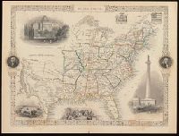
"The illustrations by J. Marchant & engraved by J. Rogers.", Probably from: The illustrated atlas, and modern history of the world, geographical, political, commercial, and statistical / Robert M. Martin. New York, [1857]., and Relief shown by hachures.
Publisher:
J. & F. Tallis,
Subject (Geographic):
United States--Maps.
Subject (Name):
John Tallis & Company, Marchant, J, and Rogers, John, approximately 1808-approximately 1888
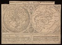
Universaltafel des situs Asiae, Africae und Europae, samt der gelegenhäit des lands Eden, wie auch eine delineatio der arch Noe bäides im grund und auftitz
Description:
Caption title., Includes two images of Noah's ark., One partial hemisphere map of Europe, Africa, and Asia and one map of the Biblical Middle East., and Relief shown pictorially.
Publisher:
[publisher not identified],
Subject (Geographic):
Middle East--Maps--Early works to 1800. and Northern Hemisphere--Maps--Early works to 1800.
Subject (Topic):
Bible.--Old Testament--Geography--Maps--Early works to 1800.
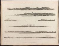
Voyage of discovery to the North Pacific ocean, and round the world.
Image Count:
1
Resource Type:
Maps, Atlases & Globes
Description:
Cape Mendocino ... / J. Sykes, delt. -- Cape Orford ... / J. Sykes -- Cape Orford bear[in]g. S.S.E. 10 miles distant / J. Sykes -- Cape Gregory -- Point Grenville ... / J. Sykes -- Entrance to the Straits of Juan de Fuca ... / H. Humphrys, delt. -- A continuation of the above coast s[out]hward. from Cape Flattery, Mount Olympus ... / H. Humphrys. and Seven views on 1 sheet.
Publisher:
Published May 1st, 1798, by R. Edwards, New Bond Street, J. Edwards Pall Mall & G. Robinson, Paternoster Row,
Subject (Name):
Alexander, William (1767-1816), Edwards, James, 1756-1816, Edwards, Richard, Humphrys, Henry, -1799, and Pouncy, Benjamin Thomas, d.
Subject (Topic):
Coasts--Northwest Coast of North America--Pictorial works--Early works to 1800.
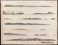
Voyage of discovery to the North Pacific ocean, and round the world.
Image Count:
1
Resource Type:
Maps, Atlases & Globes
Alternative Title:
Cape Colnett., Entrance of Port St. Diego., Entrance of Port St. Francisco., Point Pinos ... River Carmelo., Punto de los Reyes ... and the Bay of Sir Francis Drake., Santa Barbara., and Two remarkable mountains to the southward of St. Diego.
Description:
Punto de los Reyes ... and the Bay of Sir Francis Drake ... / H. Humphrys, delt. -- The entrance of Port St. Francisco ... / T. Heddington, delt.-- Point Pinos ... River Carmelo ... / H. Humphreys, delt. -- Santa Barbara ... / J. Sykes, delt. -- The entrance of Port St. Diego ... Punta de Loma ... / T. Heddington, delt. -- Two remarkable mountains to the southward of St. Diego / T. Heddington, delt. -- Cape Colnett ... / T. Heddington, delt. and Seven views on 1 sheet.
Publisher:
Published May 1st, 1798, by R. Edwards, New Bond Street, J. Edwards Pall Mall & G. Robinson, Paternoster Row,
Subject (Name):
Alexander, William (1767-1816), Edwards, James, 1756-1816, Edwards, Richard, Fittler, James, 1758-1835, and Robinson, George, 1736-18
Subject (Topic):
Coasts--California--Pictorial works--Early works to 1800. and Coasts--Mexico--Baja California (State)--Pictorial works--Early works to 1800.
Voyage of discovery to the North Pacific ocean, and round the world.
Image Count:
1
Resource Type:
Maps, Atlases & Globes
Description:
Six views on 1 sheet. and The westernmost of Scots Islands ... / T. Heddington, delt. -- Cape Scot ... / J. Sykes, delt. -- Woody Point ... / J. Sykes -- The entrance of Nootka Sound ... / H. Humphrys, delt. -- The entrance of Columbia River, Cape Disappointment ... / H. Humphrys -- Punto Barro de Arena ... / H. Humphrys.
Publisher:
Published May 1st, 1798, by R. Edwards, New Bond Street, J. Edwards Pall Mall & G. Robinson, Paternoster Row,
Subject (Name):
Alexander, William (1767-1816), Edwards, James, 1756-1816, Edwards, Richard, Heddington, Thomas, 1775 or 1776-1860, and Humphrys, Hen
Subject (Topic):
Coasts--Northwest Coast of North America--Pictorial works--Early works to 1800.
Voyage of discovery to the North Pacific ocean, and round the world.
Image Count:
1
Resource Type:
Maps, Atlases & Globes
Description:
Nine views in 10 segments on 1 sheet. and Tscherikow's Island ... / H. Humphries, delt. -- The entrance of Port Chatham, Cook's Inlet ... / T. Heddington -- Wingham's Island ... the w[es]t point of Kaye's Island ... & Cape Hammond ... / J. Sykes -- Cape Ommaney ... s[ou]th point of Coronation Island ... Mount Calder ... / J. Sykes -- Cape St. Lucas, [Baja] California ... / T. Heddington -- The Maria Islands lying off Port San Blas, Mexico ... T. Heddington -- Cape Corrientes ... -- The islet of Diego Ramirez to the s[ou]th of Cape Horn ... / J. Sykes -- The coast to the s[ou]th of Valparaiso, Point Quraumilla ... / J. Sykes.
Publisher:
Published May 1st, 1798, by J. Edwards Pall Mall & G. Robinson, Paternoster Row,
Subject (Geographic):
Pacific Coast (Mexico)--Pictorial works--Early works to 1800.
Subject (Name):
Alexander, William (1767-1816), Edwards, James, 1756-1816, Fittler, James, 1758-1835, Heddington, Thomas, 1775 or 1776-1860, and Humph
Subject (Topic):
Coasts--Alaska--Pictorial works--Early works to 1800. and Coasts--Chile--Pictorial works--Early works to 1800.
Relief shown by hachures., Shows locations of German factories in German West-African colonies., Text on verso with caption: 618, Brausejahre, Bilder aus Weimars Blütezeit von A. v. d. Elbe (Fortetzung)., and With inset maps: Lüderitzland (1:3,000,000), Das Kamerun-Gebeit (1:3,000,000), and Das Königreich Sachsen.
Publisher:
[publisher not identified],
Subject (Geographic):
Africa, West--Maps. and Germany--Colonies--Africa.
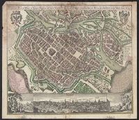
Breslau die uhralte u[nd] hochberühmte Haupt Statt des Herzogth. Schlesien auch vortrefflicher aufenthalt der Musen u[nd] florisanter Handels Plaz an dem Oder Strom and Breslau die uhralte und hochberühmte Haupt Statt des Herzogth. Schlesien auch vortrefflicher aufenthalt der Musen und florisanter Handels Plaz an dem Oder Strom
Description:
"Cum gratia et privil. S.R.I. Vicariat[us] in partib[us] Rheni, Svevice, et Juris Franconici.", Ancillary view: Breslaw. Not drawn to scale., Buildings shown pictorially., Includes index, text, and illustrations., Latin and German., and Sheet measures 56 x 40 cm.
Subject (Geographic):
Wrocław (Poland)--Aerial views--Early works to 1800. and Wrocław (Poland)--Maps--Early works to 1800.
Subject (Name):
Karpinski, Louis Charles,--1878-1956--Ownership., Karpinski-von Wieser Map Collection., and Wieser, Franz,--Ritter von,--1848-1923--Ownership.
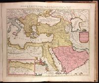
Imperium Turcicum, complectens Europae, Asiae et Africae, Arabiae que regiones ac provincias plurimas, industria et labore Petr. Schenck
Description:
Appeared in Peter Schenk's Atlas contractus., Backed with paper. Ms. no. "91" in upper right-hand corner. Sheet measures 53.6 x 62.5 cm. No. 83 of 87 maps bound together., Includes six bar scales., Inset map [partially obscuring title in cartouche] is continuation of the North African coastline., Prime meridian: Ferro., and Relief shown pictorially.
Publisher:
P. Schenck, avec privil,
Subject (Geographic):
Africa, North--Maps--Early works to 1800., Europe, Southern--Maps--Early works to 1800., Middle East--Maps--Early works to 1800., and Turkey--Maps--Early works to 1800.
Subject (Name):
Schenk, Peter, 1660-1718 or 1719. Atlas contractus.