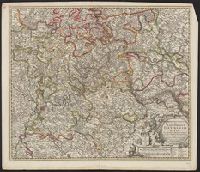
Gouwen, Gilliam van der, engraver Visscher, Nicolaes, 1649-1702, cartographer
Call Number:
36 1706
Container / Volume:
BRBL_00117
Image Count:
1
Resource Type:
Maps, Atlases & Globes
Description:
Borders are hand colored; larger cites are illustrated and colored red., Decorative title cartouche., Relief shown pictorially., Shows towns, rivers, and cities., and With reference grid.
Subject (Geographic):
Rhineland-Palatinate (Germany)--Maps--Early works to 1800
"2764"., Compiled chiefly from the Surveys by Captains Flinders, Blackwood, Stanley, Yule & Denham 1802-60, with additions from various surveys to 1885., Includes large corrections to Mar. 1896, and small corrections to "IX.11.", Prime meridian: Greenwich., and R
Subject (Geographic):
Coral Sea--Maps and Great Barrier Reef (Qld.)--Maps
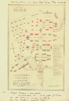
Sanborn fire insurance maps are a rich source of historic data on the urban built environment of North America during the 19th and early 20th centuries. The atlases were created for the purpose of underwriting fire insurance policies, which depended upon accurate and frequently-updated information about construction materials, municipal and transportation infrastructure, industrial and commercial landuse and more. The Yale University Library Map Department scanned its holdings of Sanborn fire insurance maps (consisting primarily of Connecticut towns) in order to make the maps more accessible.
Alternative Title:
Baltic, Connecticut and May 1911, Baltic, Conn.
Description:
"3738, 3 sheets.", Contains information on population, prevailing winds, water facilities and fire department., Includes index of specials., Partial cadastral map., and SMLMAPL 766 B217 1911: Imperfect: sheet slightly chipped and torn, with no loss of text. Sheets disbound.
Subject (Geographic):
Sprague (Conn. : Town)--Maps
Subject (Topic):
Fire risk assessment--Connecticut--Sprague (Town)--Maps and Real property--Connecticut--Sprague (Town)--Maps
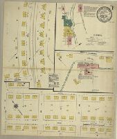
Sanborn fire insurance maps are a rich source of historic data on the urban built environment of North America during the 19th and early 20th centuries. The atlases were created for the purpose of underwriting fire insurance policies, which depended upon accurate and frequently-updated information about construction materials, municipal and transportation infrastructure, industrial and commercial landuse and more. The Yale University Library Map Department scanned its holdings of Sanborn fire insurance maps (consisting primarily of Connecticut towns) in order to make the maps more accessible.
Alternative Title:
Baltic, Conn., Jan. 1932 and Baltic, Connecticut
Description:
"(1530).", "(5 sheets).", Contains information on population, prevailing winds, water facilities and fire department., Includes index of streets and specials., Partial cadastral map., and SMLMAPL 766 B217 1932: Imperfect: sheet 1 slightly chipped, with no loss of text. Sheets disbound.
Subject (Geographic):
Sprague (Conn. : Town)--Maps
Subject (Topic):
Fire risk assessment--Connecticut--Sprague (Town)--Maps and Real property--Connecticut--Sprague (Town)--Maps