Search
You Searched For
Search Results
- Published / Created:
- Aug. 25, 1888.
- Call Number:
- Print10207
- Image Count:
- 1
- Resource Type:
- still image
- Found in:
- Medical Historical Library, Cushing/Whitney Medical Library > "What are the wild waves saying?" Try Beecham's Pills. [graphic]
- Creator:
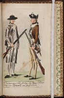
- Berger, D. (Daniel), 1744-1825
Chodowiecki, Daniel, 1726-1801
- Call Number:
- Zm Sp79
- Collection Title:
- Allgemeines historisches Taschenbuch, oder, Abriss der merkwurdigsten neuen Welt-Begebenheiten
- Image Count:
- 1
- Found in:
- Beinecke Rare Book and Manuscript Library > 1. Americanischer Scharffschuetz oder Faeger, (rifleman)
- Published / Created:
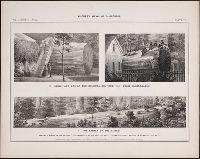
- 1862
- Call Number:
- Zc72 +862vib
- Collection Title:
- Vischer’s views of California [graphic] : the mammoth tree grove, Calaveras County, California, and
- Image Count:
- 1
- Found in:
- Beinecke Rare Book and Manuscript Library > 10. Stump and Log of the Original Big Tree, 1855. From Photographs. & 8. The Father of the Forest, pl. VII [7]
- Creator:
- Revere, Paul, 1735-1818
West, Benjamin, 1738-1820
- Published / Created:
- 1774 December
- Call Number:
- Vanderbilt 147
- Collection Title:
- An historical account of the expedition against the Ohio Indians, in the year 1764. Under the
- Image Count:
- 1
- Found in:
- Beinecke Rare Book and Manuscript Library > A Conference held between some Indian chiefs and Colonel Bouquet in the year 1764
- Creator:
- Russell, John, fl. 1733-1795
- Published / Created:
- 1794 July 26
- Call Number:
- 1986 102
- Collection Title:
- An historical, geographical, commercial, and philosophical view of the American United States, and
- Image Count:
- 1
- Found in:
- Beinecke Rare Book and Manuscript Library > A General map of North America drawn from the best sources
- Published / Created:
- 1776
- Call Number:
- Cb23 27
- Collection Title:
- The American military pocket atlas : being an approved collection of correct maps, both general and
- Image Count:
- 1
- Found in:
- Beinecke Rare Book and Manuscript Library > A General map of the northern British colonies in America. which comprehends the province of Quebec, the government of Newfoundland, Nova-Scotia, New-England and New-York. From the maps published by the Admiralty and Board of Trade regulated by the astronomic and trigonometric observations of M. von Holland and corrected from Governor Pownall's late map 1776.
- Creator:
- Romans, B
- Published / Created:
- 1776
- Call Number:
- Cb23 27
- Collection Title:
- The American military pocket atlas : being an approved collection of correct maps, both general and
- Image Count:
- 1
- Found in:
- Beinecke Rare Book and Manuscript Library > A General map of the southern British colonies, in America, comprehending North and South Carolina, Georgia, east and west Florida, with the neighbouring Indian countries. From the modern surveys of engineer de Brahm, Capt. Collet, Mouzon & others; and from the large hydrographical survey of the coasts of east and west Florida
- Creator:
- Tanner, Henry Schenck, 1786-1858
- Published / Created:
- 1822
- Call Number:
- 2003 Folio 81
- Collection Title:
- The New American Atlas ...
- Container / Volume:
- No. IV [4]
- Image Count:
- 1
- Found in:
- Beinecke Rare Book and Manuscript Library > A Map of North America, Constructed According to the Latest Information by H. S. Tanner
- Published / Created:
- 1783
- Call Number:
- Cb21 35B
- Collection Title:
- History of the war with America, France, Spain, and Holland; commencing in 1775 and ending in 1783
- Image Count:
- 1
- Found in:
- Beinecke Rare Book and Manuscript Library > A Map of the United States of America, as settled by the peace of 1783
- Call Number:
- Egf 789
- Collection Title:
- The American geography; or, A view of the present situation of the United States of America
- Image Count:
- 1
- Found in:
- Beinecke Rare Book and Manuscript Library > A Map of the northern and middle states; comprehending the western Territory and the British dominions in North America. Compiled from the best authorities