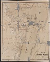
Imperfect: mutilated, with some loss of text., Map Collection acquisition record: 2757., and Removed from: Guide to West Point, New York, 1867. Egk64 W52 867
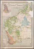
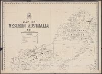
Western Australia. Department of Lands and Surveys
Published / Created:
1904
Call Number:
2651 1904
Container / Volume:
BRBL_00023
Image Count:
1
Resource Type:
Maps, Atlases & Globes
Description:
Inset: Map showing timber areas., Relief shown pictorially and by spot heights., and Shows "England and Wales on same scale as this map," "Lands held under Pastoral Lease," "Agricultural lands open for selection," and "Rainfall belts."
Publisher:
Dept. of Lands and Surveys,
Subject (Geographic):
Western Australia--Maps
Subject (Name):
Johnston, Harry F
Subject (Topic):
Land use, Rural--Australia--Western Australia--Maps
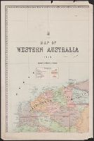
Western Australia. Department of Lands and Surveys Western Australia. Government Statistician's Office. Statistical register of Western Australia
Published / Created:
1900
Call Number:
2651fbd 1900
Container / Volume:
BRBL_00023
Image Count:
1
Resource Type:
Maps, Atlases & Globes
Description:
"Hon. Geo. Throssell MLA Minister for Lands" ; "Harry F. Johnston Surveyor General" -- under Dept. Insign and Compiled by the Dept. of Lands and Surveys and published as a plate in the Statistical Register of Western Australia for 1900 in Part V, facing p. 2.
Publisher:
Dept. of Lands & Surveys,
Subject (Geographic):
Western Australia--Administrative and political divisions--Maps
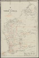
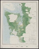
"Julius Bien & Co. Lith. N.Y.", Plate IV from the "Nineteenth annual report" of the U.S. Geological Survey, Part 5, Forest reserves (1898)., and Shows four classes of timber density and public land grid.
Publisher:
The Survey,
Subject (Name):
Geological Survey (U.S.). Annual report
Subject (Topic):
Forests and forestry--Washington (State), Western--Maps
"Showing location of buildings of Williams College, also all residences and other buildings, together with the principle bearings and distances." and Includes index to property ownership.
Publisher:
s.n.,
Subject (Geographic):
Massachusetts--Maps and Williamstown (Mass.)--Maps