Search
You Searched For
Search Results
- Published / Created:
- 1853
- Call Number:
- 806gme G132 1853A
- Container / Volume:
- BRBL_00549
- Image Count:
- 1
- Resource Type:
- Maps, Atlases & Globes
- Found in:
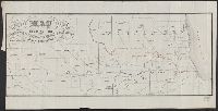
- Beinecke Rare Book and Manuscript Library > Map showing the Galena & Chicago Union Railroad and its connections.
- Creator:
- Trutch, Joseph W. (Joseph William), Sir, 1826-1904
- Published / Created:
- 1856
- Call Number:
- 846 1856
- Image Count:
- 2
- Resource Type:
- Maps, Atlases & Globes
- Found in:
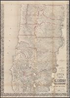
- Beinecke Rare Book and Manuscript Library > Preston's sectional and county map of Oregon and Washington : west of the Cascade mountains / compiled ... by J.W. Trutch and G.W. Hyde.
- Creator:
- Morse, Charles W. (Charles Walker), 1823-1887
- Published / Created:
- [1856?]
- Call Number:
- 815 1856D
- Container / Volume:
- BRBL_00560
- Image Count:
- 1
- Resource Type:
- Maps, Atlases & Globes
- Found in:
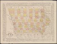
- Beinecke Rare Book and Manuscript Library > Morse's cerographic map of Iowa.
- Published / Created:
- 1857
- Call Number:
- 806 C43 1857B
- Container / Volume:
- BRBL_00548
- Image Count:
- 1
- Resource Type:
- Maps, Atlases & Globes
- Found in:
- Beinecke Rare Book and Manuscript Library > Map of Chicago.
- Published / Created:
- 1857
- Call Number:
- 806 C43 1857
- Container / Volume:
- BRBL_00548
- Image Count:
- 1
- Resource Type:
- Maps, Atlases & Globes
- Found in:
- Beinecke Rare Book and Manuscript Library > Map of Chicago.
- Published / Created:
- 1858
- Call Number:
- 806 C43 1858
- Container / Volume:
- BRBL_00548
- Image Count:
- 1
- Resource Type:
- Maps, Atlases & Globes
- Found in:
- Beinecke Rare Book and Manuscript Library > New map of Chicago : comprising the whole city, taken from Lowe's map, with all the recent additions, subdivisions & extentions.
- Published / Created:
- 1860
- Call Number:
- 806gme C43 1860
- Container / Volume:
- BRBL_00549
- Image Count:
- 1
- Resource Type:
- Maps, Atlases & Globes
- Found in:
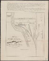
- Beinecke Rare Book and Manuscript Library > Plat exhibiting the location of the Southern Michigan and Rock Island R.R. depots and adjacent grounds. / lithographed by Ed Mendel.
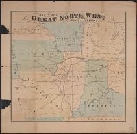
- Creator:
- Wheaton, W. G
- Published / Created:
- [186-]
- Call Number:
- 754gme 1853B
- Container / Volume:
- BRBL_00419
- Image Count:
- 1
- Resource Type:
- Maps, Atlases & Globes
- Found in:
- Beinecke Rare Book and Manuscript Library > Map of the great north west : showing Peoria, Illinois the geographigal [sic] centre / W.G. Wheaton, Civil Engineer Peoria, Ill.
- Creator:
- Colton, G. Woolworth (George Woolworth), 1827-1901
- Published / Created:
- 1862
- Call Number:
- 754gme 1860A
- Container / Volume:
- BRBL_00420
- Image Count:
- 1
- Resource Type:
- Maps, Atlases & Globes
- Found in:
- Beinecke Rare Book and Manuscript Library > Colton's county and township rail road map of Wisconsin, Illinois, Missouri, & Iowa / Drawn, engraved & published by G. Woolworth Colton
- Creator:
- Colton, G. Woolworth (George Woolworth), 1827-1901
- Published / Created:
- 1862, c1861.
- Call Number:
- 75 1862C
- Container / Volume:
- BRBL_00403
- Image Count:
- 1
- Resource Type:
- Maps, Atlases & Globes
- Found in:
- Beinecke Rare Book and Manuscript Library > G. Woolworth Colton's new guide map of the United States & Canada : with railroads, counties etc. / drawn, engraved & published by G. Woolworth Colton.
- Creator:
- Case, Francis M
- Published / Created:
- 1868
- Call Number:
- 834gme 1868
- Container / Volume:
- BRBL_00591
- Image Count:
- 1
- Resource Type:
- Maps, Atlases & Globes
- Found in:
- Beinecke Rare Book and Manuscript Library > Denver Pacific Railway map showing the final location with prospective connections : compiled from railroad and gov't. surveys / F.M. Case.
- Published / Created:
- 1870
- Call Number:
- 806 C43 1870
- Container / Volume:
- BRBL_00548
- Image Count:
- 1
- Resource Type:
- Maps, Atlases & Globes
- Found in:
- Beinecke Rare Book and Manuscript Library > Map of Chicago and environs.
- Creator:
- George F. Cram Company
- Published / Created:
- 1873
- Call Number:
- 75 1873
- Container / Volume:
- BRBL_00405
- Image Count:
- 2
- Resource Type:
- Maps, Atlases & Globes
- Found in:
- Beinecke Rare Book and Manuscript Library > The Improved American Union Railroad map of the United States, British provinces, West Indies, Mexico and Central America.
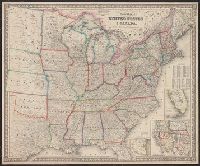
- Creator:
- Rand McNally and Company
- Published / Created:
- [ca. 1874].
- Call Number:
- 75gme 1874
- Container / Volume:
- BRBL_00412
- Image Count:
- 1
- Resource Type:
- Maps, Atlases & Globes
- Found in:
- Beinecke Rare Book and Manuscript Library > New map of the American overland route : showing its connections, and land grants of 30,000,000 acres / engraved and published by Rand McNally & Co.
- Published / Created:
- 1874
- Call Number:
- 806am C43 1874
- Container / Volume:
- BRBL_00549
- Image Count:
- 1
- Resource Type:
- Maps, Atlases & Globes
- Found in:
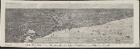
- Beinecke Rare Book and Manuscript Library > Bird's-eye view of Chicago and its environs : showing a distance of 45 miles on Lake Michigan, and 26 miles westward / drawn by R.W. Wallis.
- Published / Created:
- [1874?].
- Call Number:
- 75gma 1874
- Container / Volume:
- BRBL_00411
- Image Count:
- 1
- Resource Type:
- Maps, Atlases & Globes
- Found in:
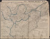
- Beinecke Rare Book and Manuscript Library > All water route map from the Mississippi to the Eastern Atlantic / [Printed for] The Illinois and Mississippi River and Canal Improvement Commission, Davenport, Iowa.
- Creator:
- Rand McNally and Company
- Published / Created:
- 1876
- Call Number:
- 792 1876
- Container / Volume:
- BRBL_00518
- Image Count:
- 1
- Resource Type:
- Maps, Atlases & Globes
- Found in:
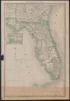
- Beinecke Rare Book and Manuscript Library > Rand McNally & Co.'s Florida [cartographic material].
- Creator:
- Rand McNally and Company
- Published / Created:
- 1878
- Call Number:
- 806 1878R
- Container / Volume:
- BRBL_00547
- Image Count:
- 1
- Resource Type:
- Maps, Atlases & Globes
- Found in:
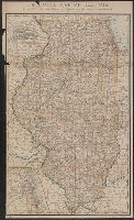
- Beinecke Rare Book and Manuscript Library > Railroad map of Illinois : prepared for the 1878 Report of Railroad and Warehouse Commissioners / by Rand, McNally & Co.
- Creator:
- Rand McNally and Company
- Published / Created:
- 1879
- Call Number:
- 811 1879
- Container / Volume:
- BRBL_00552
- Image Count:
- 1
- Resource Type:
- Maps, Atlases & Globes
- Found in:
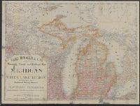
- Beinecke Rare Book and Manuscript Library > Rand, McNally & Co.'s township, county and railroad map of Michigan and the entire Upper Lake Region : showing the celebrated mining districts of the Upper Peninsula / compiled from the U.S. Land Office and Lake Surveys, County Surveys, etc.
- Published / Created:
- 1880
- Call Number:
- 811 1880
- Container / Volume:
- BRBL_00552
- Image Count:
- 1
- Resource Type:
- Maps, Atlases & Globes
- Found in:
- Beinecke Rare Book and Manuscript Library > Railroad map of Michigan / prepared for the Commissioner of railroads.
- Creator:
- Rand McNally and Company
- Published / Created:
- c1881.
- Call Number:
- 804 1881
- Container / Volume:
- BRBL_00543
- Image Count:
- 1
- Resource Type:
- Maps, Atlases & Globes
- Found in:
- Beinecke Rare Book and Manuscript Library > Rand McNally & Co.'s new sectional and township map of Ohio.
- Published / Created:
- 1881
- Call Number:
- 787 1881
- Container / Volume:
- BRBL_00517
- Image Count:
- 1
- Resource Type:
- Maps, Atlases & Globes
- Found in:
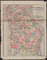
- Beinecke Rare Book and Manuscript Library > New Map of Georgia: showing railroads, Congressional districts and counties / Prepared expressly for the State Railroad Commission.
- Published / Created:
- [1881]
- Call Number:
- 771 1881
- Container / Volume:
- BRBL_00479
- Image Count:
- 1
- Resource Type:
- Maps, Atlases & Globes
- Found in:
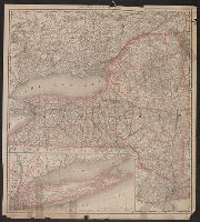
- Beinecke Rare Book and Manuscript Library > Rand McNally & Co's New York.
- Creator:
- Rand McNally and Company
- Published / Created:
- 1882
- Call Number:
- 818 1882
- Container / Volume:
- BRBL_00565
- Image Count:
- 2
- Resource Type:
- Maps, Atlases & Globes
- Found in:
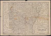
- Beinecke Rare Book and Manuscript Library > New railroad and township map of Arkansas.
- Creator:
- Rand McNally and Company
- Published / Created:
- December 1st, 1882.
- Call Number:
- 796 1882A
- Container / Volume:
- BRBL_00526
- Image Count:
- 1
- Resource Type:
- Maps, Atlases & Globes
- Found in:
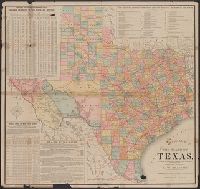
- Beinecke Rare Book and Manuscript Library > Official map of the state of Texas : to accompany the statistical and descriptive work, "Resources, soil and climate of Texas" / prepared under the direction of A.W. Spaight, Commissioner of Insurance, Statistics and History.
- Creator:
- Rand McNally and Company
- Published / Created:
- c1882.
- Call Number:
- 793 1882
- Container / Volume:
- BRBL_00520
- Image Count:
- 1
- Resource Type:
- Maps, Atlases & Globes
- Found in:
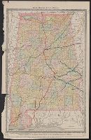
- Beinecke Rare Book and Manuscript Library > Rand McNally & Co.'s Alabama.
- Creator:
- Rand McNally and Company
- Published / Created:
- [1882]
- Call Number:
- 75gme 1882B
- Container / Volume:
- BRBL_00413
- Image Count:
- 2
- Resource Type:
- Maps, Atlases & Globes
- Found in:
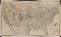
- Beinecke Rare Book and Manuscript Library > A correct map of the United States of America showing the Atchison, Topeka and Santa Fe R.R. and connections.
- Creator:
- Rand McNally and Company
- Published / Created:
- [1882?]
- Call Number:
- 75gme 1882A
- Container / Volume:
- BRBL_00413
- Image Count:
- 1
- Resource Type:
- Maps, Atlases & Globes
- Found in:
- Beinecke Rare Book and Manuscript Library > New map of the United States showing the complete railway system of the trans-Missouri country / prepared expressly for Crofutt's New overland tourist and Pacific coast guide, 1882, the Overland Publishing Company, Omaha, Neb., and Denver, Colo.
- Creator:
- George F. Cram Company
- Published / Created:
- [1883?]
- Call Number:
- 826 1883
- Container / Volume:
- BRBL_00577
- Image Count:
- 1
- Resource Type:
- Maps, Atlases & Globes
- Found in:
- Beinecke Rare Book and Manuscript Library > Railroad and county map of Indian Ty.
- Creator:
- Rand McNally and Company
- Published / Created:
- 1883
- Call Number:
- 80gme 1883
- Container / Volume:
- BRBL_00539
- Image Count:
- 1
- Resource Type:
- Maps, Atlases & Globes
- Found in:
- Beinecke Rare Book and Manuscript Library > Chicago, Burlington & Quincy R.R., and intersecting lines.