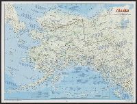
National Geographic Society (U.S.). Cartographic Division
Published / Created:
1983
Call Number:
848 1983
Container / Volume:
BRBL_00631
Image Count:
2
Resource Type:
Maps, Atlases & Globes
Alternative Title:
The making of America: Alaska.
Description:
"Supplement to the National Geographic, January 1984, page 50A, vol. 165, no. 1.", Inset: Continuation of the Aleutian Islands on same scale as main map., Relief shown by shading and spot heights., Text, maps, ill. on verso., and Title when folded: The making of America: Alaska.
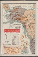
"No. 20"--Upper right margin., "The Yukon River, ranges of mountains, shores of Norton Sound and many features of the interior from a reconnaissance by W.H. Dall, Director of the Scientific Corps, of the W.U. Tel. Expedition, 1865-1868.", and Inset: Aleutian Islands.
Publisher:
U.S. Coast Survey,
Subject (Geographic):
Alaska--Maps and Yukon Territory--Maps
Subject (Name):
Dall, William Healey, 1845-1927 and Lindenkohl, H. (Henry)
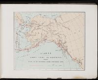
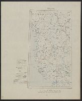
A souvenir of the Harriman Alaska Expedition : May-August, 1899 [graphic]
Image Count:
1
Resource Type:
Maps, Atlases & Globes
Abstract:
Edward Henry Harriman organized and funded a scientific expedition up the Alaska coast that included George Bird Grinnell, Grove Karl Gilbert, John Muir, Frederick Dellenbaugh, C. Hart Merriam, and other scientists, artists and writers, as well as his own
Subject (Geographic):
Alaska--Description and travel
Subject (Name):
Harriman Alaska Expedition (1899)--Pictorial works
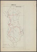
Great Britain. Royal Air Force. Central Interpretation Unit
Published / Created:
1943
Call Number:
475 1944
Container / Volume:
BRBL_00262
Image Count:
1
Resource Type:
Maps, Atlases & Globes
Alternative Title:
Geographical Section, General Staff ; no. 4415, GSGS (Series) ; 4415., and Vlonë (Valona) city plan
Description:
"1-44.", "1943.", "First G.S.G.S. edition, 1943.", "Ground information supplied by I.S.T.D.", "War Office 1943.", Inset: [Krionero]., Military grid., and Relief shown by contours, land form drawings, and one spot height.
"War Office, November 1918." and Red overprint: At head of map, "Map No.1, Portion of sheets Sofiya & Athenai. International Map 1:1,000,000"; on body of map, reference chart showing land claims corresponding to lines on map; at bottom left margin, "Geographi