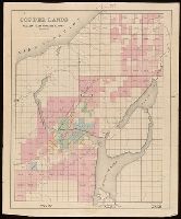
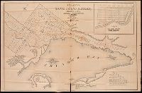
Backed with linen. Manuscript annotations on map. Manuscript title on verso: Portage Lake. From the Richard H. Rickard Papers. and Coordinates not present on map and are approximated.
Publisher:
[publisher not identified],
Subject (Geographic):
Keweenaw Peninsula (Mich.)--Maps.
Subject (Name):
Rickard, Richard H.,---1885--Ownership. and St. Mary's Canal Mineral Land Company--Maps.
Subject (Topic):
Copper mines and mining--Michigan--Keweenaw Peninsula--Maps.
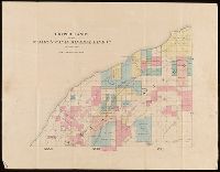
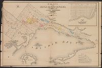
Backed with linen. Manuscript annotations on map. Manuscript title on verso: Eagle River & Cliff Mine District. From the Richard H. Rickard Papers. and Coordinates not present on map and are approximated.
Publisher:
[publisher not identified],
Subject (Geographic):
Keweenaw County (Mich.)--Maps.
Subject (Name):
Rickard, Richard H.,---1885--Ownership. and St. Mary's Canal Mineral Land Company--Maps.
Subject (Topic):
Copper mines and mining--Michigan--Keweenaw County--Maps.
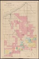
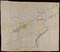
Backed with linen. Manuscript annotations on map. Manuscript title on verso: Ontonagon village & Minnesota mine. From the Richard H. Rickard Papers. and Coordinates not present on map and are approximated.
Publisher:
[publisher not identified],
Subject (Geographic):
Ontonagon County (Mich.)--Maps.
Subject (Name):
Rickard, Richard H.,---1885--Ownership. and St. Mary's Canal Mineral Land Company--Maps.
Subject (Topic):
Copper mines and mining--Michigan--Ontonagon County--Maps.
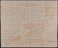
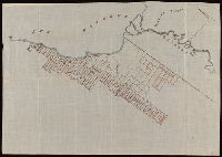
Backed with linen. Manuscript annotations on map. Manuscript title on verso: Copper Harbour & Eagle Harbour. From the Richard H. Rickard Papers. and In upper left corner: 59.
Publisher:
[publisher not identified],
Subject (Geographic):
Keweenaw County (Mich.)--Maps. and Michigan--Keweenaw County
Subject (Name):
Delaware Mining Company of Michigan--Maps., Friend, Norman M., approximately 1815-, Pennsylvania Mining Company of Michigan--Maps., and Rickard, Richard H.,---1885--Ownership.
Subject (Topic):
Copper mines and mining, Copper mines and mining--Michigan--Keweenaw County--Maps., Landowners, Landowners--Michigan--Keweenaw County--Maps., Mines and mineral resources, and Mines and mineral resources--
Coordinates not present on map and are approximated., Imperfect: mutilated, with some loss of text. Manuscript annotations on map. Manuscript title on verso: Thunder Bay Silver Mining District. From the Richard H. Rickard Papers., Inset: plan of town plot, Fort William., and Relief shown by hachures.
Publisher:
[publisher not identified],
Subject (Name):
Copp Clark Company and Rickard, Richard H.,---1885--Ownership.
Subject (Topic):
Real property--Ontario--Thunder Bay Region--Maps. and Silver mines and mining--Ontario--Thunder Bay Region--Maps.
Coordinates not present on map and are approximated., Imperfect. Mutilated with loss of text., Inset: plan of town plot, Fort William., and Relief shown by hachures.
Publisher:
[publisher not identified],
Subject (Name):
Copp Clark Company and Rickard, Richard H.,---1885--Ownership.
Subject (Topic):
Real property--Ontario--Thunder Bay Region--Maps. and Silver mines and mining--Ontario--Thunder Bay Region--Maps.
Map of Thunder Bay District, Canada, showing silver lands owned by Peter Mitchell and others
Description:
Accompanied by mailing envelope addressed in manuscript to R.H. Rickard., Coordinates not present on map and are approximated., From the Richard H. Rickard Papers., North oriented towards the upper right., and Title devised by cataloger from manuscript note on accompanying envelope.
Subject (Name):
Rickard, Richard H.,---1885--Ownership.
Subject (Topic):
Landowners--Ontario--Thunder Bay--Maps., Real property--Ontario--Thunder Bay--Maps., and Silver mines and mining--Ontario--Thunder Bay--Maps.
Imperfect: all sheets but southeast sheet wanting. Manuscript title on verso, "Sault Ste. Marie to Lake Nipissing." From the Richard H. Rickard Papers. and Title devised by cataloger; description based on imperfect copy.