
You Searched For
1 - 8 of 8
Search Results
- Creator:
- Hendges, M
- Published / Created:
- 1898
- Call Number:
- 848 1898J
- Container / Volume:
- BRBL_00630
- Image Count:
- 1
- Resource Type:
- Maps, Atlases & Globes
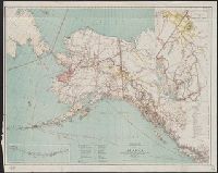
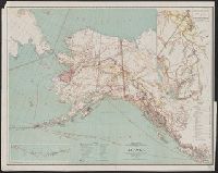
- Description:
- At head of title: Department of the Interior, General Land Office, Hon. Binger Hermann, Commissioner., Includes distance table and inset maps of "From Juneau to Forty Mile Creek" and the Aleutian Islands., Relief shown by shading and spot heights., and Shows land offices and reservations, transportation routes, mineral deposits, reported gold regions, isothermal lines, and religious missions by denomination.
- Publisher:
- General Land Office,
- Subject (Geographic):
- Alaska--Maps
- Subject (Name):
- Norris Peters Co and United States. General Land Office
- Found in:
- Beinecke Rare Book and Manuscript Library > Map of Alaska / compiled from the official records of the General Land Office, U.S. Coast & Geodetic Survey, U.S. Geological Survey, Canadian and other sources, under the direction of Harry King ; compiled and drawn by M. Hendges.
- Creator:
- Hendges, M
- Published / Created:
- 1898
- Call Number:
- 848 1898J
- Container / Volume:
- BRBL_00630
- Image Count:
- 1
- Resource Type:
- Maps, Atlases & Globes
- Description:
- At head of title: Department of the Interior, General Land Office, Hon. Binger Hermann, Commissioner., Includes distance table and inset maps of "From Juneau to Forty Mile Creek" and the Aleutian Islands., Relief shown by shading and spot heights., and Shows land offices and reservations, transportation routes, mineral deposits, reported gold regions, isothermal lines, and religious missions by denomination.
- Publisher:
- General Land Office,
- Subject (Geographic):
- Alaska--Maps
- Subject (Name):
- Norris Peters Co and United States. General Land Office
- Found in:
- Beinecke Rare Book and Manuscript Library > Map of Alaska / compiled from the official records of the General Land Office, U.S. Coast & Geodetic Survey, U.S. Geological Survey, Canadian and other sources, under the direction of Harry King ; compiled and drawn by M. Hendges.
- Creator:
- O'Hare, Daniel
- Published / Created:
- 1906
- Call Number:
- 842 1906
- Container / Volume:
- BRBL_00599
- Image Count:
- 1
- Resource Type:
- Maps, Atlases & Globes
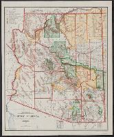
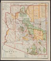
- Description:
- Includes inset of the Sonora railway and township diagram showing sections and quarter-sections., Prime meridians: Washington and Greenwich., Relief shown by shading., and Shows counties, Indian, forest, and military reserves, private land grants, and townships.
- Publisher:
- General Land Office,
- Subject (Geographic):
- Arizona--Administrative and political divisions--Maps and Arizona--Maps
- Subject (Name):
- Bond, Frank, 1856-1940, Norris Peters Co, and United States. General Land Office
- Subject (Topic):
- Forest reserves--Arizona--Maps and Indian reservations--Arizona--Maps
- Found in:
- Beinecke Rare Book and Manuscript Library > Territory of Arizona / compiled from the official records of the General Land Office and other sources under the direction of Frank Bond ; compiled and drawn by Daniel O'Hare.
- Creator:
- O'Hare, Daniel
- Published / Created:
- 1907
- Call Number:
- 842 1907A
- Container / Volume:
- BRBL_00599
- Image Count:
- 1
- Resource Type:
- Maps, Atlases & Globes
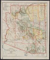
- Description:
- "Norris Peters Co., photo-litho.", Includes inset of the Sonora railway and township diagram., Prime meridians: Greenwich and Washington., Relief shown by shading., and Shows counties, forest, Indian, and military reserves, private land grants, roads, railways, township grid, etc.
- Publisher:
- General Land Office,
- Subject (Geographic):
- Arizona--Administrative and political divisions--Maps and Arizona--Maps
- Subject (Name):
- Berthrong, I. P, Norris Peters Co, and United States. General Land Office
- Subject (Topic):
- Forest reserves--Arizona--Maps and Indian reservations--Arizona--Maps
- Found in:
- Beinecke Rare Book and Manuscript Library > Territory of Arizona / compiled from the official records of the General Land Office and other sources under the direction of I.P. Berthrong ; compiled and drawn by Daniel O'Hare.
- Creator:
- O'Hare, Daniel
- Published / Created:
- 1908
- Call Number:
- 842 1908A
- Container / Volume:
- BRBL_00599
- Image Count:
- 1
- Resource Type:
- Maps, Atlases & Globes
- Description:
- "Norris Peters Co., photo-litho.", Includes inset of the Sonora railway and township diagram., Prime meridians: Greenwich and Washington., Relief shown by shading., and Shows counties, forest, Indian, and military reserves, private land grants, roads, railways, township grid, etc.
- Publisher:
- General Land Office,
- Subject (Geographic):
- Arizona--Administrative and political divisions--Maps and Arizona--Maps
- Subject (Name):
- Berthrong, I. P, Norris Peters Co, and United States. General Land Office
- Subject (Topic):
- Forest reserves--Arizona--Maps and Indian reservations--Arizona--Maps
- Found in:
- Beinecke Rare Book and Manuscript Library > Territory of Arizona / compiled from the official records of the General Land Office and other sources under the direction of I.P. Berthrong ; compiled and drawn by Daniel O'Hare.
- Creator:
- United States. General Land Office
- Published / Created:
- 1896
- Call Number:
- 842 1896
- Container / Volume:
- BRBL_00598
- Image Count:
- 1
- Resource Type:
- Maps, Atlases & Globes
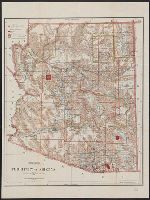
- Description:
- Prime meridians: Greenwich and Washington., Relief shown by shading., and Shows counties, Indian, military, and forest reservations, private claims, and townships.
- Publisher:
- General Land Office,
- Subject (Geographic):
- Arizona--Administrative and political divisions--Maps and Arizona--Maps
- Subject (Name):
- Hendges, M, Morton, Robert H, Norris Peters Co, and Towson, R. M
- Subject (Topic):
- Forest reserves--Arizona--Maps and Indian reservations--Arizona--Maps
- Found in:
- Beinecke Rare Book and Manuscript Library > Territory of Arizona / revised and reconstructed by R.H. Morton ; compiled from the official records of the General Land Office and other sources under supervision of Harry King, C.E. ; lettered by M. Hendges and R.M. Towson.
- Creator:
- United States. Dept. of the Treasury. Bureau of Statistics
- Published / Created:
- [190-?]
- Call Number:
- 70GM 1900
- Container / Volume:
- BRBL_00359
- Image Count:
- 1
- Resource Type:
- Maps, Atlases & Globes
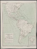
- Description:
- Includes inset (scale 1:60,000,000) of "Density of population in South America".
- Publisher:
- Bureau of Statistics,
- Subject (Geographic):
- Railroads--Latin America--Maps, Railroads--United States--Maps, Steamboat lines--Atlantic Ocean--Maps, and Steamboat lines--Pacific Ocean--Maps
- Subject (Name):
- Norris Peters Co
- Found in:
- Beinecke Rare Book and Manuscript Library > Transportation routes between the United States and other American countries / U.S. Treasury Department, Bureau of Statistics ; [B.?] Olszewski.