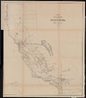
"Sen. Ex. Doc. No. 1, 34th Cong., 1st Sess.", From: Report of the Commissioner of the General Land Office, 1856., Relief shown by hachures., and Shows drainage, township lines, etc.
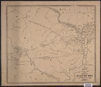
"Entered according to act of Congress in the Clerks Office of the U.S. District Court by V.P. Corbett in the year 1861 for the Dist. of Colum[bi]a." and "Map of northern Virginia showing troop camps, entrenchments, forts, batteries, roads, railroads, street p
Publisher:
Lith. by A. Hoen & Co., and V.P. Corbett ;
Subject (Geographic):
Manassas Region (Va.)--History--Civil War, 1861-1865--Maps and Washington Metropolitan Area--History--Civil War, 1861-1865--Maps
Department of State publication ; 803. and Department of State, map series ; no. 5 (Publication no. 803)
Description:
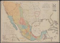
"Reproduced in 1935 to accompany ʻTreaties and other international acts of the United States of America,ʾ Volume 5. See Document 129.", "The earliest of five or more 1847 editions. The copy added to the Treaty of Guadalupe Hidalgo of February 2, 1848, in the archives of the Department of State.", Includes table of distances, table of statistics, "Profile of the route between Mexico and Vera Cruz," and "Profile of the route b[e]tween Mexico and Acapulco.", Insets: Carta de los caminos &c. desde Vera Cruz y Alvarado a Méjico -- Map showing the battle grounds of the 8th and 9th May 1846 -- Chart of the bay of Vera Cruz., Prime meridian: Washington., and Relief shown by hachures and spot heights.
"The Disturnell Map of 1847 reproduced for the Friends of the Bancroft Library, February 2, 1948.", Includes distance table, "tabla estadistica," and 2 profiles., Insets: Carta de los caminos &c. desde Vera Cruz y Alvarado a Méjico -- Map showing the battle grounds of the 8th and 9th May 1846 -- Chart of the bay of Vera Cruz., Issued to accompany: The Treaty of Guadalupe Hidalgo ... / edited by George P. Hammond. 1949., Prime meridian: Washington., and Relief shown by hachures and spot heights.
Publisher:
The Friends of the Bancroft Library,
Subject (Geographic):
Mexico--Boundaries--United States--Maps, Mexico--Maps, Southwest, New--Maps, and United States--Boundaries--Mexico--Maps
Subject (Name):
A. Hoen & Co, Bancroft Library. Friends, and Mexico. Treaties, etc. United States, 1848 Feb. 2
"Entered according to Act of Congress in the year 1850 by John Monk in the Clerks Office of the District of Maryland.", Includes: Legend, Table of distances, routes by water, inland routes, Names of counties and county towns in the United States., and Inset: Ne
Publisher:
Jacob Monk,
Subject (Geographic):
Central America--Maps, Mexico--Maps, North America--Maps, United States--Maps, and West Indies--Maps
Surveyor General of Iowa, Wisconsin, and Minnesota
Published / Created:
1855
Call Number:
812 1855C
Container / Volume:
BRBL_00555
Image Count:
1
Resource Type:
Maps, Atlases & Globes
Alternative Title:
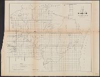
No. 1, Sketch of public surveys in Wisconsin and territory of Minnesota.
Description:
"Surveyor General's Office, Dubuque, October 21st 1855, Warner Lewis.", At head of title: (No. 1)., Blindstamps of Columbia College Library, N, Coordinates not present on map and are approximated., and Sen. Ex. Doc. No. 1, 54th Cong., 1st Sess.
Publisher:
Surveyor General's Office,
Subject (Geographic):
Minnesota--Maps, Minnesota--Surveys--Maps, Wisconsin--Maps, and Wisconsin--Surveys--Maps
Subject (Name):
A. Hoen & Co, Columbia College (New York, N.Y.). Library Stamp, and Lewis, Warner, 1805-1888
National Geographic Society (U.S.). Cartographic Division
Published / Created:
c1959
Call Number:
7821 1959
Container / Volume:
BRBL_00506
Image Count:
1
Resource Type:
Maps, Atlases & Globes
Description:
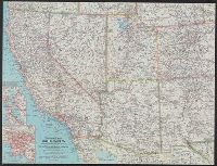
Below title: Atlas plate 12, November 1959., Insets, [ca. 1:750,000]: [Map of San Francisco area] -- [Map of Los Angeles area]., and Relief shown by shading and spot heights. Depths shown by soundings and isolines.
Publisher:
The Society,
Subject (Geographic):
Southwest, New--Maps
Subject (Name):
A. Hoen & Co and Darley, James M. (James Morrison)