Skip to search
Skip to main content
Skip to first result
Search
You Searched For
Genre
Maps
New Search
Search Results
Creator:
Published / Created:
1911
Call Number:
60bh 1911
Container / Volume:
BRBL_00329
Image Count:
1
Resource Type:
Maps, Atlases & Globes
Alternative Title:
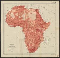
Exploration of Africa
Description:
Issued with the Geographical Journal, 1911., Relief shown by spot heights., and Shows areas mapped from surveys, traverses, native reports or entirely unknown.
Publisher:
Royal Geographical Society,
Subject (Geographic):
Africa--Historical geography--Maps
Subject (Topic):
Discoveries in geography--Africa--Maps
Found in:
Beinecke Rare Book and Manuscript Library > Africa showing progress of exploration / published by the Royal Geographical Society.
Creator:
Published / Created:
1592]
Call Number:
60 1592
Container / Volume:
BRBL_00321
Image Count:
2
Resource Type:
Maps, Atlases & Globes
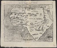
Description:
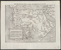
Appears in Bünting's Itinerarium Sacrae Scripturae., In top margin: 20 -- 21., Includes ill., Latin, German., Relief shown pictorially., Sheet measures 32 x 39 cm., and Text on verso.
Publisher:
Heinrich Bünting,
Subject (Geographic):
Africa--Maps--Early works to 1800
Subject (Name):
Bünting, Heinrich, 1545-1606. Itinerarium Sacrae Scripturae
Found in:
Beinecke Rare Book and Manuscript Library > Africa tertia pars terrae.
Creator:
Published / Created:
1667
Call Number:
60 1667
Container / Volume:
BRBL_00322
Image Count:
1
Resource Type:
Maps, Atlases & Globes
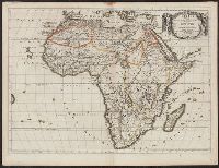
Description:
"Cum privilegio ad viginti annos.", Has watermark., Relief shown pictorially., and Sheet measures 46 x 59 cm.
Publisher:
Apud Petrum Mariette, via Iacobaea sub signo spei,
Subject (Geographic):
Africa--History--Maps--Early works to 1800
Subject (Name):
Sanson, Guillaume
Found in:
Beinecke Rare Book and Manuscript Library > Africa vetus / Nicolai Sanson, Christianiss. Galliar. Regis geographi ; recognita emendata et multis in locis mutata, conatibus geographicis Gulielmi Sanson N[icolai] filii.
Creator:
Published / Created:
1720?]
Call Number:
60 1720
Container / Volume:
BRBL_00322
Image Count:
1
Resource Type:
Maps, Atlases & Globes
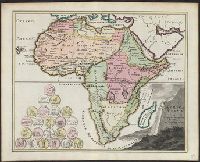
Description:
Includes ill. of coins., Relief shown pictorially., and Shows historical place names and boundaries.
Publisher:
C. Weigel,
Subject (Geographic):
Africa--Historical geography--Maps--Early works to 1800 and Africa--Maps--Early works to 1800
Found in:
Beinecke Rare Book and Manuscript Library > Africa vetus / per Christophorum Wegelium, Normibergae, cum privilegio sac[ra] Caes[areae] Majestatis.
Creator:
Published / Created:
1792?]
Call Number:
60 1792
Container / Volume:
BRBL_00324
Image Count:
1
Resource Type:
Maps, Atlases & Globes
Alternative Title:
Route of Mr. Mungo Park.
Description:
"Engrav'd for Jackson's edition of Payne's new System of universal geography.", Has watermarks., Library copy attached to Route of Mr. Mungo Park., Prime meridian: London., and Relief shown pictorially.
Publisher:
Jackson,
Subject (Geographic):
Africa--Maps--Early works to 1800
Subject (Name):
Ferguson, engraver, Jackson, Zachariah, and Payne, John, fl. 1800. Universal geography formed into a new and entire system
Found in:
Beinecke Rare Book and Manuscript Library > Africa, 1792 / Ferguson sculpsit.
Creator:
Published / Created:
ca. 1545]
Call Number:
60 1545
Container / Volume:
BRBL_00321
Image Count:
2
Resource Type:
Maps, Atlases & Globes
Description:
German title and text, Latin place names., Includes text and ill., Relief shown pictorially., Sheet measures 34 x 42 cm., and Text in ornamental frame on verso: Des gantzen Landts Africe, ein gemeine beschreibung. xxv.
Publisher:
s.n.,
Subject (Geographic):
Africa--Maps--Early works to 1800
Found in:
Beinecke Rare Book and Manuscript Library > Africa, Lybia, Mörenlandt, mit allen Königreichen, so zü unsern Zeiten darin̄ gefunden werden.
Call Number:
1976 1233
Collection Title:
Forty-two new maps of Asia, Africa, and America ... : all engrav’d, according to the latest
Image Count:
1
Alternative Title:
Africa in general
Description:
In ink on verso: 13.
Subject (Geographic):
Africa --Maps --Early works to 1800
Subject (Name):
Nicholson, John, d. ca. 1717, bookseller
Subject (Topic):
Atlases --Early works to 1800
Collection Created:
London : Printed for J. Nicholson ..., 1716 ...
Found in:
Beinecke Rare Book and Manuscript Library > Africa, according to ye newest and most exact observations
Creator:
Published / Created:
1595]
Call Number:
60 1595
Container / Volume:
BRBL_00321
Image Count:
2
Resource Type:
Maps, Atlases & Globes
Description:
"Cum priuilegio.", Hand col. Sheet measures 47 x 57 cm., Includes text and ornamental cartouche., Latin, French., Pg. nos. on verso: 61, 64., Relief shown pictorially., Running title on verso: L'Afrique., and Signature on verso: Q.
Publisher:
Gerard Mercator,
Subject (Geographic):
Africa--Maps--Early works to 1800
Found in:
Beinecke Rare Book and Manuscript Library > Africa, ex magna orbis terre descriptione Gerardi Mercatoris / desumpta, studio & industria G.M. Iunioris.
Creator:
Published / Created:
1832
Call Number:
60 1832
Container / Volume:
BRBL_00325
Image Count:
1
Resource Type:
Maps, Atlases & Globes
Publisher:
Published by John Harris, St. Pauls Church Yard,
Subject (Geographic):
Africa--Maps
Subject (Name):
Gaultier, abbé (Aloisius Edouard Camille), 1746?-1818 and Hewitt, N. R
Found in:
Beinecke Rare Book and Manuscript Library > Africa, for the elucidation of the Abbé Gaultier's geographical games [cartographic material] / by Jehoshaphat Aspin, 1832 ; N.R. Hewitt, sculp.
Creator:
Published / Created:
3. Jany., 1826.
Call Number:
60 1826
Container / Volume:
BRBL_00325
Image Count:
1
Resource Type:
Maps, Atlases & Globes
Description:
Includes chart showing political divisions by region., On verso: 37., Prime meridians: Greenwich and Ferro., Relief shown pictorially., and Watermark: Whatman 1825.
Publisher:
Published ... by Robert Wilkinson, no. 125 Fenchurch Street : and Republished with additions and corrections by William Darton, 58 Holborn Hill,
Subject (Geographic):
Africa--Maps
Subject (Name):
Baker, B, Baker, E, and Darton, William, Jun
Found in:
Beinecke Rare Book and Manuscript Library > Africa, including Arabia and the Mediterranean / E. Baker delin. ; B. Baker sculp.
Branch:v1.61.6 ,Deployed:2024-06-12T09:55:36-04:00