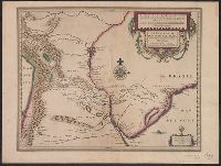
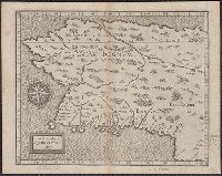
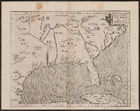
Paragvay, ó, prov. de Rio de la Plata cum regionibus adiacentibus Tvcvman et Sta. Crvz de la Sierra
Description:
Bar scales in "Milliaria Germanica communia" and "Milliaria Gallica communia.", Blank on verso., Cross Collection no. 345., From Jodocus Hondius's Appendix Atlantis majoris. [Amsterdam] : Per Iodocum Hondium, 1630., Mounted on linen., and Relief shown pictorially.
Publisher:
Iodocus Hondius excudit,
Subject (Geographic):
Argentina--Maps--Early works to 1800, Paraguay--Maps--Early works to 1800, and Uruguay--Maps--Early works to 1800
Subject (Name):
Hondius, Jodocus, 1594 or 1595-1629. Appendix Atlantis majoris
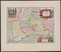
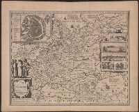
Appears in Jansson's Atlas novus, vol. 1, ca. 1680; also appears in the English Atlas, vol. 1, by Moses Pitt et al., ca. 1680., Bottom center: "Ex officina Janssonio-Waesbergiana, et Mosis Pitt.", Relief shown pictorially., and Sheet measures 54 x 62 cm. Numbered "6" in ink ms. Lada-Mocarski Collection.
Publisher:
s.n.,
Subject (Geographic):
Russia--Maps--Early works to 1800
Subject (Name):
Jansson, Jan, 1588-1664. Atlas novus and Pitt, Moses, active 1654-1696. English atlas
"Cum privil. S. Caes. M.", Includes inset view of "St. Petersburg," ornamental cartouche, and text., and Verso: Stamped "Yale Univ. Lib. Map Coll. Nov 21 1975". Lada-Mocarski Collection.
Publisher:
Homann heirs,
Subject (Geographic):
Ingria (Russia)--Maps--Early works to 1800 and Saint Petersburg Region (Russia)--Maps--Early works to 1800
Appears in the Seutter's Atlas novus., Includes text and ill., Prime meridian: Tenerife., Relief shown pictorially., Sheet measures 53.8 x 60.7 cm. Ms. nos. on verso: 97; 112. Franklin Collection no. 131., and Variant of McLaughlin's state 5, with table with crucifix, chalice, ad urn. McLughlin's state 5 shows woman with cross and cup; table with single urn; full trees; text (bottom right): Cum Gratia et Privil. S.R.I. Vicariatg, in partibg Rheni, Sueuiae, et Juris Franconici; "Mendocino" and "Pta de los Reyes"; Clima labels in borders; and text at left above equator.
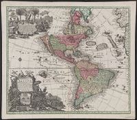
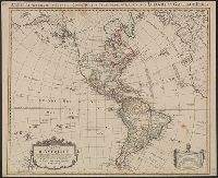
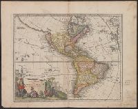
America accurate in imperia, regna, status, et populos divisa, ad usum Ludovici XV. Galliarum Regis
Description:
In French, with additional title in Latin., Includes "Avertissement"., Relief shown pictorially., and Sheet measures 51.5 x 63 cm. Numbered "108" in ink ms. Franklin Collection.
Publisher:
Chez Covéns & Mortier & Covéns Junior,
Subject (Geographic):
America--Maps--Early works to 1800
Subject (Name):
Anville, Jean Baptiste Bourguignon d', 1697-1782, Condet, Johannes, 1711-1781, engraver, and Covens et Mortier et Covens, junior
At least three states of the 1746 map exist: one state has the privilige statement "Cum Privil S.C.M." following publisher and preceding date in the cartouche, but without engraver statement "Seb. Dorn, sc." below neat line; another state has no privilege statement, but has engraver statement below neat line; and another state has no privilege statement or engraver statement, but lists "Falkland" below I. Malouines (off the southern coast of Argentia), which is missing from all other states., Relief shown pictorially., and With privilege statement in cartouche. Sheet measures 50 x 59.5 cm. Verso: "8" in ink ms. Franklin Collection.
Publisher:
In lucem proferentibus Homannianis Heredibus,
Subject (Geographic):
America--Maps--Early works to 1800 and Western Hemisphere--Maps--Early works to 1800
Subject (Name):
Boehme, August Gottlieb, 1719-1797 and Hase, Johann Matthias, 1684-1742
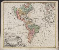
America occidentalium indiarum nomine Vulgo celebratissima non i[m]merito Europa Nova appellari posset
Description:
2nd state, with California correctly shown as a peninsula., Appears in Homann's Atlas novus., Prime meridian: Teneriffe., Relief shown pictorially., and Sheet measures 50.5 x 62.5 cm. Ms. nos. on verso: 66; 148, America. Franklin Collection 131 1710.
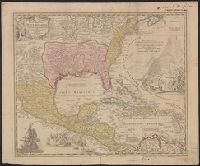
Appears in Homann's Atlas geographicus major ... Normibergae : Curantibus Homannianis heredibus, 1759., Includes notes, ill. of ships in battle, and of Europeans and Native Americans, and four bar scales., Ms. annotations. Ms. no. on verso: 207 III 59. Sheet measures 53.6 x 64.9 cm. Franklin Collection no. 131 1737-2., Relief shown pictorially., Some references suggest earlier possible imprint date., and This edition is at least the second state, as Ludoviciana has replaced Florida as the name of the Louisiana territory.
Publisher:
[Homann Erben?,
Subject (Geographic):
New Spain--Maps--Early works to 1800 and North America--Maps--Early works to 1800
Subject (Name):
Homann Erben (Firm) and Homann, Johann Baptist, 1663-1724. Atlas geographicus major
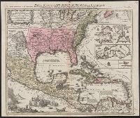
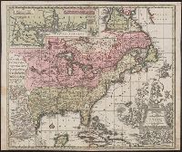
Appears in various eds. of Atlas geographicus maior., Includes German text relating to English and French territorial claims., Neat lines measures 45.8 x 50.8 cm. on sheet 50 x 57.5 cm. Ms. note on verso: No. 151, Nord America nach d'Anville. Franklin Collection no. 131 1756-9., Place names and descriptive notes in English., Prime meridian: Ferro and London., and Relief shown pictorially.
Publisher:
[Homann Erben],
Subject (Geographic):
North America--Maps--Early works to 1800 and United States--History--French and Indian War, 1755-1763--Maps--Early works to 1800
Subject (Name):
Anville, Jean Baptiste Bourguignon d', 1697-1782 and Homann Erben (Firm). Atlas geographicus maior
"Cum gratia et privil S.R.I. Vicariatus in partibus Rheni Suevice et Juris Franconici.", Manuscript number in upper right corner: 105., and Relief shown pictorially.
Publisher:
[Matthaeus Seutter],
Subject (Geographic):
Caribbean Area--Maps--Early works to 1800, Central America--Maps--Early works to 1800., Mexico--Maps--Early works to 1800., North America--Maps--Early works to 1800, and United States--Maps--Early works to 1800
Franklin Collection no. 131 1780. Sheet measures 49.8 x 60.8 cm., Includes "Annotatio" and five bar scales., Prime meridian: Ferro., Relief shown pictorially., and Watermark.
Publisher:
Venalis prostat Augustae Vindelicorum apud Tobiam Conr. Lotter,
Subject (Geographic):
North America--Maps--Early works to 1800
Subject (Name):
Lotter, Georg Friedrich, engraver and Lotter, Tobias Conrad, 1717-1777
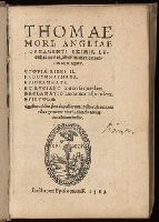
Lucubrationes, ab innumeris mendis repurgatæ. and Selections. 1563
Description:
A collection of five works and 13 letters written by Thomas More., Beinecke copy imperfect: leaves M5-N8 wormed., Contents (from title page): Vtopiæ libri II. -- Progymnasmata. -- Epigrammata. -- Ex Luciano conuersa quædam. -- Declamatio Lucianicæ respondens. -- Epistolæ., Errata (p. [45], third count)., Includes index., Signatures: alpha-beta⁸ a-z⁸ A-N⁸ (alpha 1 verso, beta 8 verso blank., Story of "Utopia" (p. [3-32], first count; 1-164, second count) set in the New World, with references to Vespucci and his voyages on p. 4-5., This collection includes: "Epistola Des. Erasmi Rot. ad Vldricum Huttenum, de Thomæ Mori Angliæ baronis uita." (p. 497-510), dated at end Antuerpiæ X. Cal. Aug. Anno M. D. XIX. [22 July 1519]; "Epistola de morte D. Thomæ Mori & Episcopi Roffensis" [Ioannis Phischeri] "insignium uirorum in Anglia. G. Courinus Nucerinus ..." (p. 511-530), dated at end: Apud Lutetiam Parisiorum, X. Cal. Augusti, Anno M. D. XXXV [22 July 1535]., This edition of Utopia includes the letters of Desiderius Erasmus to Johannes Froben, Guillaume Budé to Thomas Lupset, Pierre Gillis to Jerome Busleyden, Thomas More to Pierre Gillis and Jerome Busleyden to Thomas More. It also includes the annotations by Desiderius Erasmus., and Title vignette: Printer's device, signed: Episcop.
Publisher:
apud Episcopium F.,
Subject (Name):
Birukov, N. N.--Bookplate., Birukov, N. N.--Stamp., Courinus Nucerinus, Gulielmus, Erasmus, Desiderius, -1536., Fisher, John,--Saint,--1469-1535., More, Thomas, Saint, 1478-1535. Utopia., and More, Thomas,--Saint,--1478-1535.
Vlakke aard-kloot gemeenlyk genaamd de geheele waereld
Description:
Backed with paper. Sheet measures 53.6 x 61.9 cm. No. 1 of 87 maps bound together., Includes twelve ancillary maps., Relief shown pictorially., Scale determined by using graticule method., and Watermark.