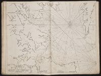
Bowen, Emanuel, d. 1767 Cook, James, 1728-1779, creator
Published / Created:
Decem'r. 1766
Call Number:
2003 Folio 85
Image Count:
1
Description:
BEIN 2003 Folio 85: No. 15 of 45 maps bound together with binder's spine title: Atlas of America; ms. table of contents. Bookplate: Robinson. Bookplate of Paul Mellon., by James Cook, when surveyor of His Majesty's Ship the Mars., Depths shown by soundings., Eman'l. Bowen sculp't., Hand colored., and Scale [ca. 1:64,000].
Publisher:
Published by the author according to Act of Parliament
Subject (Geographic):
Halifax (N.S.) -- Maps -- Early works to 1800
Subject (Topic):
Coasts -- Nova Scotia -- Maps -- Early works to 1800 and Nautical charts -- Nova Scotia -- Early works to 1800
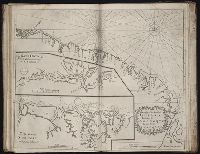
The English pilot: describing the West-India navigation, from Hudson's-Bay to the river Amazones
Image Count:
1
Subject (Geographic):
Atlantic Ocean --Maps --Early works to 1800, Dominican Republic --Maps, Manuscript --Early works to 1800, Haiti --Maps --Early works to 1800, Hispaniola --Maps --Early works to 1800, Puerto Rico --Maps --Early works to 1800, and West Indies --Maps --Early works to 1800
Subject (Topic):
Navigation --Early works to 1800, Pilot guides --Atlantic Coast (U.S.) --Early works to 1800, and Pilot guides --Caribbean Area --Early works to 1800
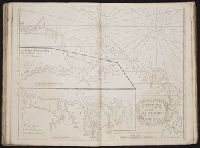
BEIN 2003 Folio 85: No. 26 of 45 maps bound together with binder's spine title: Atlas of America; ms. table of contents. Bookplate: Robinson. Bookplate of Paul Mellon., Cartouche with dedication to John Ellis, Esq., King's agent for the province of west Florida, by James Cook., Depths shown by soundings., Hand colored., Inserts are A plan of Pensacola Harbour with the marks for going in (scale 1:95,000) and A draught of Spirito Sancto and coast adjacent (scale ca. 1:140,000)., and Scale [ca. 1:550,000].
Publisher:
Published by the author according to Act of Parliament
Subject (Geographic):
Florida -- Maps -- Early works to 1800
Subject (Topic):
Coasts -- Florida -- Maps -- Early works to 1800 and Nautical charts -- Florida -- Early works to 1800
BEIN 1986 +48: With: A new booke of mapps exactly describing Europe. [London] : Tho Jenner excu., [1645?] (1986 +48) and Plates, with English t.p. and captions in French, Dutch, or Latin, from De vyerighe colom / by Jacob Aertsz Colom, first published in 1635. Cf. Koeman, C. Atlantes Neerlandici, II, p. 40.
Publisher:
By Iames Colom,
Subject (Geographic):
Benelux countries--Kings and rulers--Portraits and Benelux countries--Maps--Early works to 1800
Subject (Name):
Luttrell, Narcissus,--1657-1732--Inscription.--696 % pro
Lodge, John, 1756 or 7-1830, engraver Roberts, Henry, Lieut
Published / Created:
1785
Call Number:
1977 Folio 177
Image Count:
2
Resource Type:
Maps, Atlases & Globes
Alternative Title:
Political magazine.
Description:
At foot of title: Political Mag. Jany. 1785., From: The political magazine and Parliamentary, naval, military, and literary journal. London : Printed for J. Bew, 1784., Imperfect: left sheet wanting. Right sheet measures 64.2 x 48.0 cm. Ms. note at head of title: Cook's voyages. Ms. note on verso: Map of Cook's last voyage. No. 12 of 34 maps bound together., Prime meridian: Greenwich., and World map showing the Endeavour's track in the years 1768-1771, Resolution's first voyage in 1772-1775 and Resolution's second voyage in 1776-1780.
Publisher:
Printed for J. Bew],
Subject (Topic):
Voyages around the world--Maps--Early works to 1800 and World maps--Early works to 1800