Skip to search
Skip to main content
Skip to first result
Search
You Searched For
Format
cartographic
New Search
Search Results
Creator:
Published / Created:
1805
Call Number:
Folio Q115 H84 5
Collection Title:
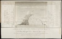
Essai sur la geographie des plantes, accompagne dun tableau physique des regions equinoxiales
Image Count:
1
Resource Type:
Prints & Photographs
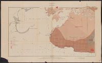
Description:
At foot: Esquisse et redige par M. de Humboldt, dessine par Schonberger et turpin a Paris en 1805, grave par Bouquetm la Lettre par Beauble, imprime par Langlois.
Subject (Geographic):
South America
Subject (Topic):
Botany --South America., Discoveries in geography., and Plants
Collection Created:
Paris : F. Schoell, 1807
Found in:
Beinecke Rare Book and Manuscript Library > Geographie des plantes equinoxiales. / Tableau physiquw des Andes et Pays voisins/ Dresse d'apres des Observations & des Mesures preises Sir les Lieux depuis le 10 degre de latitude boreale jusqu'au 10 de latitude australe en 1799, 1800, 1801, 1802 at 180
Published / Created:
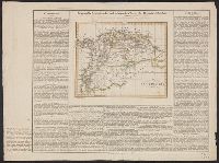
1823
Call Number:
902 1823
Container / Volume:
BRBL_00665
Image Count:
1
Resource Type:
Maps, Atlases & Globes
Description:
[with text from an atlas.]
Publisher:
Geographische Institut,
Subject (Geographic):
Colombia--Maps
Found in:
Beinecke Rare Book and Manuscript Library > Geographisch-statische und historische charte der Republik Colombia.
Published / Created:
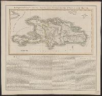
1824
Call Number:
853 1824
Container / Volume:
BRBL_00640
Image Count:
1
Resource Type:
Maps, Atlases & Globes
Description:
Text.
Publisher:
Geographische Institut,
Subject (Geographic):
Hispaniola--Maps--Early works to 1800
Found in:
Beinecke Rare Book and Manuscript Library > Geographisch-statistische und historische charte von Hayti.
Published / Created:
[1717?]
Call Number:
36es 1717
Container / Volume:
BRBL_00128
Image Count:
1
Resource Type:
Maps, Atlases & Globes
Description:
Inset: A map of North Holland.
Subject (Geographic):
Germany--Maps--Early works to 1800
Found in:
Beinecke Rare Book and Manuscript Library > Geographische Vorstellung der jämmerlichen Wasser-Flutt in Nieder-Teutschland ...
Creator:
Published / Created:
1912
Call Number:
848 G95 1912
Container / Volume:
BRBL_00632
Image Count:
1
Resource Type:
Maps, Atlases & Globes
Alternative Title:
Geological Survey bulletin. 498. and Headwater region of Gulkana and Susitna Rivers, Alaska
Description:
"Bulletin 498, Plate I.", Relief shown by contours and spot heights., and Surveyed in 1896, 1909, 1910.
Publisher:
Geological Survey,
Subject (Geographic):
Gulkana River Region (Alaska)--Maps and Susitna River Region (Alaska)--Maps
Subject (Name):
Bagley, James Warren, 1881-1947, Brooks, Alfred H. (Alfred Hulse), 1871-1924, Giffin, C. E, and Witherspoon, D. C
Subject (Topic):
Geology--Alaska--Gullkana River Region--Maps and Geology--Alaska--Sustina River Region--Maps
Found in:
Beinecke Rare Book and Manuscript Library > Geologic reconnaissance map of headwater region of Gulkana and Susitna Rivers, Alaska / U.S. Geological Survey. Alfred H. Brooks, geologist in charge of division, topography and triangulation by D.C. Witherspoon, C.E. Giffin and J.W. Bagley.
Published / Created:
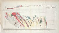
ca. 1855
Call Number:
WA Prints +4
Container / Volume:
Report of explorations for railroad routes from San Francisco Bay to Los Angeles...and from the Pimas Villages to the Rio Grande...by Lieutenant John G. Parke 1854-1855. Volume VII from Reports of explorations and surveys, to ascertain the most practicab
Image Count:
1
Found in:
Beinecke Rare Book and Manuscript Library > Geological Plan & Section from Rio Grande to the Pimas Villages along the route explored by Lieut. John G. Parke, Corps of Topl. Engrs. near the 32o north latitude. 1856. Prepared to accompany the report of Thomas Antiselol M.D. geologist of the expediti
Creator:
Published / Created:
1890
Call Number:
735CA R13 1890
Container / Volume:
BRBL_00382
Image Count:
1
Resource Type:
Maps, Atlases & Globes
Alternative Title:
Geological Survey Department, Canada
Description:
"Compiled and drawn by S. Barlow, Chief Draughtsman, and A.E. Barlow, B.A. 1886. Trace and prepared for Engraver by L.N. Richard, B. App. Sc. 1890." and "Geologically Surveyed by A.C. Lawson, MA, Ph. D. See Part C.C., Vol. I. Annual Report 1885, and Part F. A
Publisher:
Geological Survey Dept.,
Subject (Geographic):
Québec (Province)--Maps
Found in:
Beinecke Rare Book and Manuscript Library > Geological and topographical map of the southern part of the Lake of the Woods and Rainy River : Rainy River sheet.
Creator:
Published / Created:
between 1844 and 1899?]
Call Number:
815ca 1890
Container / Volume:
BRBL_00561
Image Count:
1
Resource Type:
Maps, Atlases & Globes
Description:
Below title area: C.B. Graham, lithogr., Coordinates not present on map and are approximated., Relief shown by hachures., and Shows lead mines and copper, iron and zinc ores.
Publisher:
s.n.,
Subject (Name):
Graham, C. B. (Curtis B.)
Subject (Topic):
Geology--Illinois--Maps, Geology--Iowa--Maps, Geology--Wisconsin--Maps, Mines and mineral resources--Illinois--Maps, Mines and mineral resources--Iowa--Maps, and Mines and mineral resources--Wisconsin--Ma
Found in:
Beinecke Rare Book and Manuscript Library > Geological chart of part of Iowa, Wisconsin, and Illinois / by D.D. Owen.
Published / Created:
1875
Call Number:
753CA 1875
Container / Volume:
BRBL_00415
Image Count:
1
Resource Type:
Maps, Atlases & Globes
Description:
Insert of Newfoundland, Nova Scotia, and Gulf of St. Lawrence.
Subject (Name):
Bradley, Frank Howe, 1838-1879, [map]
Subject (Topic):
Geology--Canada--Maps and Geology--United States--Maps
Found in:
Beinecke Rare Book and Manuscript Library > Geological chart of the United States, east of the Rocky Mountains, and of Canada / compiled by Frank H. Bradley, Prof. Geol., East Tennessee University.
Creator:
Published / Created:
1899
Call Number:
736CA W73 1899
Container / Volume:
BRBL_00382
Image Count:
1
Resource Type:
Maps, Atlases & Globes
Description:
"664.", Depth shown by soundings., and Includes geological legend.
Publisher:
Geological Survey of Canada,
Subject (Name):
Dowling, D. B. (Donaldson Bogart), 1858-1925 and Geological Survey of Canada
Subject (Topic):
Geology--Manitoba--Winnipeg, Lake, Region--Maps
Found in:
Beinecke Rare Book and Manuscript Library > Geological map of Lake Winnipeg and vicinity / by J.B. Tyrrell and D.B. Dowling.
Branch:v1.61.8 ,Deployed:2024-06-20T11:15:04-04:00