Outline map of the United States and Middle America showing proposed routes of the Pacific Rail Road and its branches in connection with the various systems of existing and unfinished rail roads from the Mississippi Valley to the Atlantic and Gulf coasts.
Description:
A table of distances appears to the right of the map., Designed to accompany Senator William Gwin's Congressional Bill of 1852., and Lithograph, printed in black with rail routes in red.
Publisher:
General Land Office,
Subject (Name):
Pacific Railroad and United States. General Land Office
Subject (Topic):
Railroads--North America--Maps and Railroads--United States--Maps
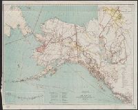
At head of title: Department of the Interior, General Land Office, Hon. Binger Hermann, Commissioner., Includes distance table and inset maps of "From Juneau to Forty Mile Creek" and the Aleutian Islands., Relief shown by shading and spot heights., and Shows land offices and reservations, transportation routes, mineral deposits, reported gold regions, isothermal lines, and religious missions by denomination.
Publisher:
General Land Office,
Subject (Geographic):
Alaska--Maps
Subject (Name):
Norris Peters Co and United States. General Land Office
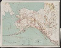
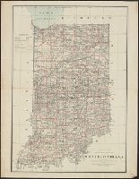
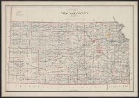
At head of title: Department of the Interior, General Land Office, J.A. Williamson, Commissioner., Prime meridians: Greenwich, Washington., and Shows railroad land grant limits.
Publisher:
General Land Office,
Subject (Geographic):
Indiana--Maps
Subject (Name):
Bien, Julius, 1826-1909 and United States. General Land Office
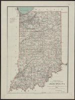
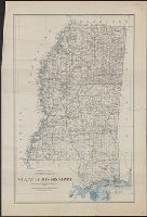
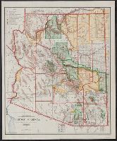
"J.S. Williamson, Commissioner.", Prime meridians: Greenwich and Washington., Relief shown by hachures., and Shows drainage, county boundaries, railroads, railroad grants, military & Indian reservations, townships, etc.
Publisher:
General Land Office,
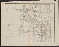
Subject (Geographic):
Arizona--Administrative and political divisions--Maps and Arizona--Maps
Subject (Name):
Bien, Julius, 1826-1909 and United States. General Land Office
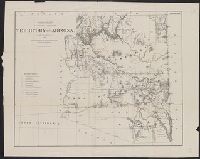
Includes inset of the Sonora railway and township diagram showing sections and quarter-sections., Prime meridians: Washington and Greenwich., Relief shown by shading., and Shows counties, Indian, forest, and military reserves, private land grants, and townships.
Publisher:
General Land Office,
Subject (Geographic):
Arizona--Administrative and political divisions--Maps and Arizona--Maps
Subject (Name):
Bond, Frank, 1856-1940, Norris Peters Co, and United States. General Land Office
Subject (Topic):
Forest reserves--Arizona--Maps and Indian reservations--Arizona--Maps