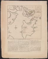
"Published according to act of Parliament by Thos. Jefferys ... ", Meridian: Ferro., Relief shown pictorially. Depths shown by soundings., and Upper right corner: VII.
Publisher:
Printed & Sold by R. Sayer & J. Bennett, No. 53 in Fleet Street,
Subject (Geographic):
Cape Breton Island (N.S.)--Maps--Early works to 1800, New England--Maps--Early works to 1800, and Nova Scotia--Maps--Early works to 1800
From Jefferys's The American atlas ... London : Printed and sold by R. Sayer and J. Bennett, 1776., Insets: A particular survey of the Isles of Montreal -- The city of Quebec -- Course of the river St. Laurence, from La Valterie to Quebec -- Plan of Montreal, or Víllemarie., Prime meridian: London., Relief shown pictorially., and Watermark.
Publisher:
Printed for Robt. Sayer and John Bennett,
Subject (Geographic):
Québec (Province)--Maps--Early works to 1800
Subject (Name):
Jefferys, Thomas, -1771. American atlas and Robert Sayer and John Bennett (Firm)
From Jefferys's The American atlas ... London : Printed and sold by R. Sayer and J. Bennett, 1776. and Insets: A particular survey of the Isles of Montreal -- The city of Quebec -- Course of the river St. Laurence, from La Valterie to Quebec -- Plan of Montreal, or Víllemarie.
Publisher:
Printed for Robt. Sayer and John Bennett,
Subject (Geographic):
Québec (Province)--Maps--Early works to 1800
Subject (Name):
Jefferys, Thomas, -1771. American atlas and Robert Sayer and John Bennett (Firm)
Hand col. Sheet measures 60 x 49 cm. Stamp on verso: Horace Brown 1900S., In lower margin: The following description of the action near Boston, on the 17th of June, is taken from a letter written by General Burgoyne to his nephew, and Relief shown by hachures.
Publisher:
Printed for R. Sayer & J. Bennett, No. 53 in Fleet Street, as the act directs,
Subject (Geographic):
Boston (Mass.)--History--Siege, 1775-1776--Maps--Early works to 1800
Subject (Name):
Burgoyne, John, 1722-1792 and Robert Sayer and John Bennett (Firm)
Subject (Topic):
Bunker Hill, Battle of, Boston, Mass., 1775--Maps--Early works to 1800
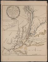
From Thomas Jeffery's American atlas. 1778., Imperfect: southern portion of text torn along fold and separated. Sheets pasted together to form one map. No. "17" stamped on verso, upper right corner., Insets: A chart of the mouth of Hudson's River, from Sandy Hook to New York.--A plan of the city of New York.--Plan of Amboy, with its environs, from an actual survey., Prime meridian: London., Relief shown pictorially., Shows administrative divisions., and Watermarks.
Publisher:
Printed for Robt. Sayer & John Bennett ...,
Subject (Geographic):
New Jersey--Administrative and political divisions--Maps--Early works to 1800., New Jersey--Maps--Early works to 1800., New York (N.Y.)--Maps--Early works to 1800, New York (State)--Administrative and political divisions--Maps--Early works to 1800., Northeastern States, Northeastern States--Maps--Early works to 1800., Perth Amboy (N.J.)--Maps--Early works to 1800., and Québec (Province)--Maps--Early works to 1800
Subject (Name):
Holland, Samuel, 1728-1801 and Robert Sayer and John Bennett (Firm)