Search
You Searched For
Search Results
- Creator:
- MacCoun, Townsend, 1845-1932
- Published / Created:
- ©1909.
- Call Number:
- 771 N49 1730
- Container / Volume:
- BRBL_00484
- Image Count:
- 1
- Resource Type:
- Maps, Atlases & Globes
- Found in:
- Beinecke Rare Book and Manuscript Library > 1730 New York, the English Colonial city / by Townsend MacCoun ; L.L. Poates Engr'g. Co.
- Published / Created:
- [1909?]
- Call Number:
- 771 N49 1783
- Container / Volume:
- BRBL_00484
- Image Count:
- 1
- Resource Type:
- Maps, Atlases & Globes
- Found in:
- Beinecke Rare Book and Manuscript Library > 1783 Manhattan Island at the close of the Revolution showing the American City with its Landmarks ... Fortifications ... L.L. Poates Engr'g Co., N.Y.
- Creator:
- United States. Congress. House. Committee on the Public Lands
- Published / Created:
- [1878?].
- Call Number:
- 75 1878
- Container / Volume:
- BRBL_00406
- Image Count:
- 16
- Resource Type:
- Maps, Atlases & Globes
- Found in:
- Beinecke Rare Book and Manuscript Library > 1876 Centennial map of the United States and territories : showing the extent of public surveys, indian and military reservations, land grant R.R. rail roads, canals, cities, towns & other details / compiled from the official surveys of the General Land O
- Creator:
- Horký, Karel, 1879-1965
Lenhard, J
- Published / Created:
- c1917.
- Call Number:
- 30 1917B
- Container / Volume:
- BRBL_00032A
- Image Count:
- 1
- Resource Type:
- Maps, Atlases & Globes
- Found in:
- Beinecke Rare Book and Manuscript Library > 1914--1915--1916--1917--?? / drawn by J. Lenhard.
- Creator:
- Thomas Bros. Maps
- Published / Created:
- [1928]
- Call Number:
- 844 R524 1928
- Container / Volume:
- BRBL_00607
- Image Count:
- 2
- Resource Type:
- Maps, Atlases & Globes
- Found in:
- Beinecke Rare Book and Manuscript Library > 1928 map of Riverside / compiled & published by Thomas Bros.
- Creator:
- George F. Cram Company
- Published / Created:
- [1930]
- Call Number:
- 827 1930
- Container / Volume:
- BRBL_00577
- Image Count:
- 2
- Resource Type:
- Maps, Atlases & Globes
- Found in:
- Beinecke Rare Book and Manuscript Library > 1930 census map of Oklahoma / George F. Cram Company, engravers and publishers.
- Creator:
- H.M. Gousha Company
- Published / Created:
- [1931]
- Call Number:
- 824gmb 1931
- Container / Volume:
- BRBL_00572
- Image Count:
- 2
- Resource Type:
- Maps, Atlases & Globes
- Found in:
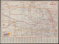
- Beinecke Rare Book and Manuscript Library > 1931 official road map, Nebraska / [prepared for] Shell.
- Creator:
- H.M. Gousha Company
- Published / Created:
- [1931]
- Call Number:
- 822gmb 1931
- Container / Volume:
- BRBL_00567
- Image Count:
- 2
- Resource Type:
- Maps, Atlases & Globes
- Found in:
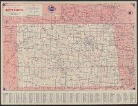
- Beinecke Rare Book and Manuscript Library > 1931 official road map, North Dakota / this map showing main trunk and highways is distributed with the compliments of Standard Oil Company (Indiana).
- Creator:
- Rand McNally and Company
- Published / Created:
- [1932]
- Call Number:
- 814gmb 1932
- Container / Volume:
- BRBL_00559
- Image Count:
- 2
- Resource Type:
- Maps, Atlases & Globes
- Found in:
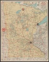
- Beinecke Rare Book and Manuscript Library > 1932 Texaco road map, Minnesota.
- Published / Created:
- [1932?], c1931.
- Call Number:
- 833gmb 1932
- Container / Volume:
- BRBL_00586
- Image Count:
- 2
- Resource Type:
- Maps, Atlases & Globes
- Found in:
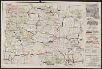
- Beinecke Rare Book and Manuscript Library > 1932 highway map of the state of Wyoming.