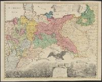
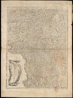
Preliminary record. and The map (bounded by Frisia, Jutland, Prussia, Poland and extending South to include Silesia and parts of Bavaria and Lotharingia) occupies the upper half of the sheet; the lower half shows an engraved battle scence ...
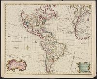
Includes text., Prime meridian: Ferro., Relief shown pictorially., Shows northwest coast in the form used in Guillaume De L'Isle's 1722 map of America. Cf. Wagner, H.R. Cartog. of the NW coast, p. 142., and Tooley refers to this map in Mapping of America, p. 13,
Publisher:
s.n.,
Subject (Geographic):
America--Maps--Early works to 1800
Subject (Name):
L'Isle, Guillaume de, 1675-1726 and L'Isle, Joseph Nicolas de, 1688-1768
No more published. Edited by Ivan Barkov. Cf. V.S. Sopikov, Opyt rossiĭskoĭ biblīografīi, 1904, no. 6063., Half title: Li︠e︡topisʹ Nestorova s prodolzhateli︠a︡mi po Kenigsbergskomu spisku, do 1206 goda., "Zhitīe prepodobnago Nestora": p. [i]-xii., Includes index., and Errata: p. 49-50 (last sequence).
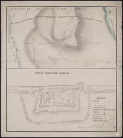
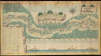
Генеральной планъ Боровицкимъ порогамъ отъ Опеченской до Потерпельской пристани ...
Description:
Coordinates cannot be determined., Includes illustration and inset listing distances between various locations., Manuscript annotaions on verso., and Relief shown pictorially.
Subject (Geographic):
Novgorodskai︠a︡ oblastʹ (Russia)--Maps--Early works to 1800.
"Podlinnai︠a︡ podpisana sobstvennoi︠u︡ e︠i︡a imperatorskago velichestva pukoi︠u︡ tako Ekaterina, M.P., pechatana v Senati︠e︡ 1785 goda apri︠e︡li︠a︡ 24 dni︠a︡"--P. 47. and Ms. shelf mark: 12217. Ms. table of contents [in Cyrillic]. Shelf label with ms. no. "12217" on front paste-down endpaper. No. 2 of 8 works bound together with binder's title: Ustavyĭ raznyi︠a︡.
Publisher:
s.n.,
Subject (Geographic):
Russia--Politics and government--1689-1801.
Subject (Name):
Russia. Sovereign (1762-1796 : Catherine II) and Russia.--Gramota na prava i vygody gorodam Rossiĭskoĭ Imperii.
Subject (Topic):
Law reform--Russia--Early works to 1800. and Municipal government--Russia--Early works to 1800.
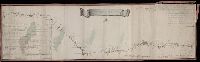
Карта большой Санктпетербургской дороге лежашей чрезъ Тверскую губернію / губернский землемеръ Андрей Петин.
Description:
Includes two insets, one showing the number of inhabitants in the 46 towns and villages along the road, the other the distances between various locations. and Mounted on silk. Manuscript annotation on map.
Subject (Geographic):
Tverskai︠a︡ oblastʹ (Russia)--Maps--Early works to 1800.