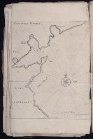
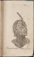
The English pilot: describing the sea-coasts, capes, head-lands, rivers, bays, roads, havens
Image Count:
1
Description:
Most maps numbered in pencil on verso, some on recto.
Subject (Geographic):
Atlantic Ocean --Maps --Early works to 1800 and Newfoundland and Labrador --Maps --Early works to 1800
Subject (Topic):
Navigation --Early works to 1800, Pilot guides --Atlantic Coast (U.S.) --Early works to 1800, and Pilot guides --Caribbean Area --Early works to 1800
Collection Created:
London : Printed for John Thornton, at the sign of the England, Scotland, and Ireland, in the Minories, and Richard Mount, at the Postern on Tower-Hill, 1698London : Printed for John Thornton, at the sign of the England, Scotland, and Ireland, in the Minories, and Richard Mount, at the Postern on Tower-Hill, 1698
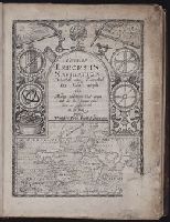
Certaine errors in nauigation / detected and corrected by Edw. Wright ; with many additions that
Image Count:
1
Abstract:
Engraved title page depicts world map at bottom with various navigation intsruments along sides and top, as well as a day and night themed sky at top left and top right, respectively.
Description:
In ink at bottom: B1., Printer’s error: lower right corner of title page offset; title page repeated on verso of *2., and With an additional engraved title page.
Subject (Topic):
Cosmography--Early works to 1800, Nautical astronomy --Early works to 1800, and Navigation --Early works to 1800
Collection Created:
[London] : Printed by Felix Kingsto[n] at London, 1610
Certaine errors in nauigation / detected and corrected by Edw. Wright ; with many additions that
Image Count:
1
Abstract:
Engraved title page depicts world map at bottom with various navigation intsruments along sides and top, as well as a day and night themed sky at top left and top right, respectively.
Description:
In ink at top right corner: 5 [underlined]., Printer’s error: lower right corner of title page offset; title page repeated on verso of *2., and With an additional engraved title page.
Subject (Topic):
Cosmography--Early works to 1800, Nautical astronomy --Early works to 1800, and Navigation --Early works to 1800
Collection Created:
[London] : Printed by Felix Kingsto[n] at London, 1610
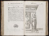
A parallel of the antient architecture with the modern : in a collection of ten principal authors
Image Count:
1
Resource Type:
Books, Journals & Pamphlets
Subject (Name):
Alberti, Leon Battista, 1404-1472. Treatise of statues, Evelyn, John, 1620-1706. Account of architects and architecture, and Wotton, Henry, Sir, 1568-1639. Elements of architecture
Subject (Topic):
Architecture --Orders
Collection Created:
London : Printed by T.W. for D. Brown, J. Walthoe, B. and S. Tooke, D. Midwinter, W. Mears, and F. Clay,
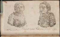
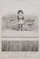
Title from item., Date derived from publisher's date of death., Place of publication from item., Title continues: in his Character of Napolean., This electronic record is derived from historic data and may not reflect our current information. Review and updating of records is ongoing., and Temporary local Medical Library subject terms: Stratton, Charles (1838-83).
Publisher:
J.T. Wood, 33, Holywell Str. Strand
Subject (Name):
Thumb, Tom, 1838-1883, and Napoleon I, Emperor of the French, 1769-1821.
The West-India pilot: containing piloting directions for Port Royal and Kingston harbours in
Image Count:
1
Subject (Geographic):
Atlantic Ocean --Maps --Early works to 1800, Central America --Maps --Early works to 1800, and Honduras --Maps
Subject (Topic):
Harbors --Atlantic Coast (North America) --Maps --Early works to 1800, Nautical charts --Atlantic Coast (North America) --Early works to 1800, Nautical charts --Caribbean Area --Early works to 1800, Nautical charts --West Indies --Early works to 1800, Pilot guides --Atlantic Coast (North America) --Early works to 1800, Pilot guides --Caribbean Area --Early works to 1800, and Pilot guides --West Indies --Early works to 1800
Collection Created:
London : Printed for the author and sold by S. Hooper ..., MDCCLXXI [1771]
Chart of the northwest coast of America and the northeast coast of Asia, explored in the years 1778 and 1779
Description:
Includes notes., No. 34 of 43 maps bound together in composite atlas., Prepared by Lieut. Heny. Roberts, under the immediate inspection of Capt. Cook ; engraved by W. Palmer., Relief shown pictorially. Depths shown by soundings., and Scale [ca. 1:13,500,000].
Publisher:
Wm. Faden, geographer to the King, Charing Cross
Subject (Geographic):
Bering Strait Region --Discovery and exploration --Maps --Early works to 1800, North America --Discovery and exploration --Maps --Early works to 1800, Pacific Coast (North America) --Discovery and exploration --Maps --Early works to 1800, and Russian Far east (Russia) --Discovery and exploration --Maps --Early works to 1800
Subject (Name):
Cook, James, 1728-1779
Subject (Topic):
Discoveries in geography --Maps --Early works to 1800