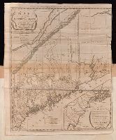
Carleton, Osgood, 1742-1816 Doolittle, Amos, 1754-1832, engraver Sullivan, James, 1744-1808. History of the district of Maine Thomas & Andrews
Published / Created:
1795
Call Number:
1977 Folio 177
Image Count:
2
Resource Type:
Maps, Atlases & Globes
Description:
In upper margin: Engraved for Judge Sullivan's History of the district of Maine., Includes references to land grants., Inset: [Southeastern Maine]. Scale [ca. 1:337,920]., Prime meridian: Washington, D.C., Relief shown by hachures., Sheet measures 54.0 x 44 cm. No. 11 of 34 maps bound together., and Shows town and county boundaries.
Publisher:
Thomas & Andrews,
Subject (Geographic):
Maine--Administrative and political divisions--Maps--Early works to 1800 and Maine--Maps--Early works to 1800
BEIN 2003 Folio 85: No. 18 of 45 maps bound together with binder's spine title: Atlas of America; ms. table of contents. Bookplate: Robinson. Bookplate of Paul Mellon., Hand colored., Includes compilation data and inset of A plan of Boston Harbor from an accurate survey, ca. 1:150,000., Prime meridian: London and Ferro., Relief shown pictorially., and Scale [ca. 1:440,000].
Fry, Joshua, 1700 (ca.)-1754, creator Halifax, George Montagu-Dunk, Earl of, 1716-1771 Jefferson, Peter, 1708-1757 Jefferys, Thomas, d. 1771
Published / Created:
[1755]
Call Number:
2003 Folio 85
Image Count:
1
Description:
BEIN 2003 Folio 85: No. 21 of 45 maps bound together with binder's spine title: Atlas of America; ms. table of contents. Bookplate: Robinson. Bookplate of Paul Mellon., drawn by Joshua Fry & Peter Jefferson in 1751., Hand colored., Includes distance chart added by J. Dalrymple, London Jany. ye. 1st. 1755., Prime meridian: Philadelphia and Curratuck Inlet., Relief shown pictorially., Scale [ca. 1:650,000]., and To the Right Honourable, George Dunk Earl of Halifax ...
Publisher:
Thos. Jeffreys
Subject (Geographic):
Maryland -- Maps -- Early works to 1800, Middle Atlantic States -- Maps -- Early works to 1800, and Virginia -- Maps -- Early works to 1800
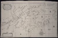
Twenty four new and accurate maps of the several parts of Europe ... : all (except the last) new
Image Count:
1
Alternative Title:
The English Channel; with the coasts of England, France, and Holland
Description:
In pencil on verso: 20. and Table of contents for maps 20-24 misnumbered.
Subject (Geographic):
Cevennes Mountains (France) --Maps, Dauphine´ Alps (France), England --Maps --To 1800, France --Maps --Early works to 1800, Lombardy (Italy) --Maps --Early works to 1800, Netherlands --Maps --Early works to 1800, and Provence-Alpes-Cote d'Azur (France) --Maps
Subject (Name):
Barker, B. (Benjamin), d. 1764, bookseller, Clements, Henry, d. 1719, bookseller, King, Charles, d. 1735, bookseller, Nicholson, John, d. ca. 1717, bookseller, Parker, Richard, fl. 1692-1725, bookseller, and Tooke, Benjamin, d. 1716, bookseller
Subject (Topic):
Atlases --Early works to 1800
Collection Created:
[London] : Sold by J. Nicholson at the King’s-Arms in Little Britain, Benj. Barker and Charles King ..., Benj. Tooke ..., Hen. Clements ..., R. Parker and Ralph Smith under the Royal-Exchange ..., [1715?]
Also appeared in Faden's [General atlas. London : William Faden, 1811?]., No. 10 of 43 maps bound together in composite atlas., Relief shown pictorially., and Scale [1: 510,000].
The discovery, settlement, and present state of Kentucky: and an essay towards the topography and
Image Count:
1
Description:
Engrav'd for S. Campbell's Edition of Imlay's Description of Kentucky., Preceding title page., and Teaching resource: Professor John Mack Faragher, History 141: The American West.
Subject (Geographic):
Kentucky --Maps --Early works to 1800 and Ohio River Valley
The English pilot: describing the sea-coasts, capes, head-lands, rivers, bays, roads, havens
Image Count:
1
Description:
Most maps numbered in pencil on verso, some on recto.
Subject (Geographic):
Atlantic Ocean --Maps --Early works to 1800, Canada --Maps --Early works to 1800, New England --Maps --Early works to 1800, Newfoundland and Labrador --Maps --Early works to 1800, and Nova Scotia --Maps --Early works to 1800
Subject (Topic):
Navigation --Early works to 1800, Pilot guides --Atlantic Coast (U.S.) --Early works to 1800, and Pilot guides --Caribbean Area --Early works to 1800
Collection Created:
London : Printed for John Thornton, at the sign of the England, Scotland, and Ireland, in the Minories, and Richard Mount, at the Postern on Tower-Hill, 1698London : Printed for John Thornton, at the sign of the England, Scotland, and Ireland, in the Minories, and Richard Mount, at the Postern on Tower-Hill, 1698