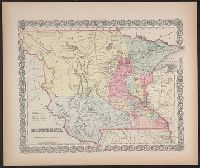
"Entered according to Act of Congress in the year 1855, by J.H. Colton & Co. ...", Accompanied by text: The territory of Minnesota. 1 leaf ; 48 cm., and Covers Minnesota Territory, including Pembina, and the Yankton, Yanktonnan and Chippewa areas, with Missouri River and White Earth River as western boundary.
Publisher:
J.H. Colton & Co.,
Subject (Geographic):
Minnesota--Maps, North Dakota--Maps, and South Dakota--Maps
Territory acquired from Mexico by the Gadsden Treaty.
Description:
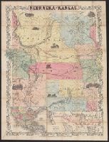
"Entered according to act of Congress in the year 1855[?] by J.H. Colton in the clerks office of the district court of the United States for the southern district of New York.", Covers Nebraska extending to the Canadian border and westward to Oregon and Kansas including present day Colorado., Includes text, ill., and insets of the United States and "Territory acquired from Mexico by the Gadsden Treaty.", and Relief shown by hachures.
Publisher:
J.H. Colton & Co.,
Subject (Geographic):
Kansas--Maps, Nebraska--Maps, and West (U.S.)--Maps
Territory acquired from Mexico by the Gadsden Treaty.
Description:
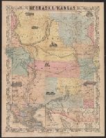
Covers Nebraska extending to the Canadian border and westward to Oregon and Kansas including present day Colorado., Includes ill., notes, and insets of map showing counties in parts of Nebraska, Kansas, Iowa, and Missouri, and map of "Territory acquired from Mexico by the Gadsden Treaty.", and Relief shown by hachures.
Publisher:
J.H. Colton & Co.,
Subject (Geographic):
Kansas--Maps, Nebraska--Maps, and West (U.S.)--Maps
Map of the territory acquired from Mexico by the Gadsden Treaty, 1854.
Description:
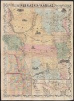
Covers Nebraska extending to the Canadian border and westward to Oregon and Kansas including present day Colorado., Includes ill. and insets of United States and "Map of the territory acquired from Mexico by the Gadsden Treaty, 1854.", and Relief shown by hachures.
Publisher:
J.H. Colton & Co.,
Subject (Geographic):
Kansas--Maps, Nebraska--Maps, and West (U.S.)--Maps
Territory acquired from Mexico by the Gadsden Treaty.
Description:
Covers Nebraska extending to the Canadian border and westward to Oregon and Kansas including present day Colorado., Includes ill., notes, and insets of map showing counties in parts of Nebraska, Kansas, Iowa, and Missouri, and map of "Territory acquired from Mexico by the Gadsden Treaty.", and Relief shown by hachures.
Publisher:
J.H. Colton & Co.,
Subject (Geographic):
Kansas--Maps, Nebraska--Maps, and West (U.S.)--Maps
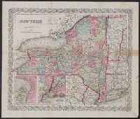
Vicinity of New York. and Vicinity of Niagara Falls.
Description:
"Entered according to Act of Congress in the year 1855, by J.H. Colton & Co. ...", Inset maps: Vicinity of Niagara Falls -- Vicinity of New York., Prime meridians: Greenwich and Washington., and Relief shown by hachures.
Publisher:
J.H. Colton & Co.,
Subject (Geographic):
New York (State)--Maps and Niagara Falls (N.Y. and Ont.)--Maps
Subject (Name):
Colton, G. Woolworth (George Woolworth), 1827-1901
J.H. Colton & Co United States. District Court (New York : Southern District)
Published / Created:
[1855]
Call Number:
18 1860
Container / Volume:
BRBL_00013
Image Count:
1
Resource Type:
Maps, Atlases & Globes
Description:
"Entered according to an act of Congress in the year 1855 by J.H. Colton & Co. in the Clerks Office of the District Court of the United States for the southern district of New York.", Relief shown by hachures and isolines., and Torn in two halves.
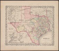
"Entered according to act of Congress in the year 1855 by J.H. Colton & Co. in the clerks office of the district court of the United States for the southern district of New York.", "No. 35.", Prime meridians: Greenwich and Washington., Relief, and Shows counties.
Publisher:
J.H. Colton & Co.,
Subject (Geographic):
Texas--Administrative and political divisions--Maps and Texas--Maps
Subject (Name):
Streeter, Thomas W.--(Thomas Winthrop),--1883-1965--Ownership
"Entered according to act of Congress, in the year 1853, by J.H. Colton, in the Clerks Office of the District Court of the United States for the Southern District of New York.", Prime meridians: Greenwich and Washington., Relief shown by hachures., and Shows state boundaries, major cities and towns, railroads, canals, military outposts, Indian tribal areas, "Indian Territory," the western territories of the United States, and Virginia as one state.
Publisher:
Published by J.H. Colton & Co., No. 172 William St.,
Subject (Geographic):
Indian Territory--Maps, Oklahoma --Maps, and United States--Maps