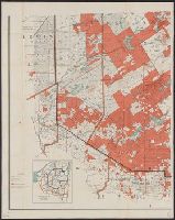
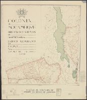
Adirondack Forest and adjoining territory. and Adirondack map, 1905.
Description:
Cadastral map showing public lands and adjacent private land ownership., Inset: Railroad and county map of northern New York., and Relief shown by shading.
"Topography is based particularly upon the Generalkarte von Mitteleuropa of the Austrian General Staff (Scale 1:300,000).", In addition to landforms, shows bodies of water, transportation infrastructure, towns, and cities., and Lists maps on which map is based.
"Assist. publishers, I.D. Peck, S. Willard Treat, A.Y. Peck, C.O. Titus, J.H.C. Dawson, L.G. Dawson." and "Entered according to Act of Congress by John E. Gillette, in the year 1859 in the clerk's office of the district court for the eastern district of Penns
Publisher:
A.R.Z. Dawson,
Subject (Geographic):
Ontario County (N.Y.)--Maps
Subject (Name):
Beers, D. G. (Daniel G.) and Dawson, A. R. Z
Subject (Topic):
Landowners--New York (State)--Ontario County--Maps
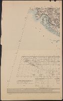
[Maury map collection ; Series F4], Maury's wind & current chart : whale sheet, and Whale sheet
Description:
"Series F.", Shows geographical locations of sperm and right whales., and The whale chart was released as series F a part of Maury's "Wind and current charts", series A-F. For complete discussion, see "The wind and current chart series produced by Matthew Fonta
Publisher:
United States Hydrographical Office,
Subject (Name):
Maury, Matthew Fontaine, 1806-1873. Wind and current charts, United States. Bureau of Ordnance and Hydrography, and United States. Hydrographic Office
Subject (Topic):
Ocean--Maps, Right whales--Maps, Sperm whale--Maps, and Whales--Maps
Accompanied by the author's: A topographical description of such parts of North America as are contained in the (annexed) map of the middle British colonies, &c. in North America. vi, 46, 16 p., Includes text, list of townships, distance charts, and inset "A sketch of the remaining part of Ohio R. &c.", Prime meridian: London and Philadelphia., Relief shown pictorially., and Without accompanying text.
Publisher:
Printed & published ... for J. Almon,
Subject (Geographic):
North America--Maps--Early works to 1800 and Northeastern States--Maps--Early works to 1800.
Subject (Name):
Almon, John, 1737-1805, Evans, Lewis, 1700?-1756, and Turner, James, -1759
"Secundum projectionem orthographicam.", Imperfect: sheets 1 and 2 stained with slight holes; no loss of text., and Relief shown by hachures and shading.
Publisher:
S. Schropp,
Subject (Geographic):
Moon--Maps
Subject (Name):
Mädler, Johann Heinrich, 1794-1874 and Simon Schropp'sche Hof-Landkartenhandlung
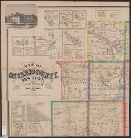
"Engraved, printed, colored & mounted at H.F. Wallings Map Establishment.", 1 map on six sheets, 57 x 86c. or smaller. Mounted on heavy paper., Includes also ill., business directories, and tables of statistics and distances., and Includes many cadastral insets
Publisher:
Smith, Gallup & Co.,
Subject (Geographic):
Berkshire County (Mass.)--Maps
Subject (Name):
Smith, Gallup & Co
Subject (Topic):
Cities and towns--Massachusetts--Berkshire County--Maps, Landowners--Massachusetts--Berkshire County--Maps, Real property--Massachusetts--Berkshire County--Maps, and Villages--Massachusetts--Berkshire County--Maps
Includes "Cuadro de Distancias Calculadas en Horas de Navegacion" and "Cuadro de Distancias del Centro y Sur del Departamento de Loreto.", Includes 2 tables of distances & travelling time between locations., Map separated into 6 sheets each 47 x 65 cm. Sheet 1 imperfect. Chewed. Sheets 4-6:2 copies., and Relief shown by shading.
"Army Map Service, U.S. Army ... Reprint January 1943.", "Copied from a map published by the F.M.S. & S.S. Survey Dept. 1928.", "Geographical Section, General Staff, No. 4253. War Office 1942.", 5844 1943:, and Includes reference chart and index to sheets.
Insets: Alaska and Aleutian Islands. and Relief shown by hachures.
Publisher:
Photolith. and printed by J. Bien,
Subject (Name):
Bien, Julius, 1826-1909 and Roeser, C. (Charles)
Subject (Topic):
Canals--United States--Maps, Indian reservations--United States--Maps, Military reservations--United States--Maps, Railroad land grants--United States--Maps, Railroads--United States--Maps, and Surveying-
Mexico. Dirección de Estudios Geográficos y Climatológicos
Published / Created:
1927?]
Call Number:
8819 1927
Container / Volume:
BRBL_00652
Image Count:
6
Resource Type:
Maps, Atlases & Globes
Description:
Includes text., Insets: Diagrama hidrológico -- Carta minera -- Plano de la Ciudad de Chihuahua / por J.F. Parada. Scale 1:20 000., and Relief shown by shading.
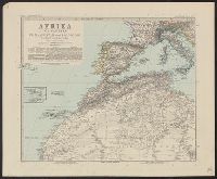
Adolf Stieler's Hand Atlas über alle Theile der Erde un über das Weltgebäude., Afrika in sechs Blättern, and Südafrika, Capland, und angrenzende Gebiete, im Massstab von 1:5.000.000.
Description:
Appears in Adolf Stieler's Hand Atlas über alle Theile der Erde und über das Weltgebäude. 1891., In top margin of each sheet, followed by consecutive numbering "no. 66" through "no. 71": Stieler's Hand Atlas., Relief shown by hachures and spot heights., and S
"F.B. Longe, R.E., Surveyor General of India. 1904.", "Lithographed from a transfer to stone at teh Survey of India Offices, Calcutta.", "Reg. No. 711-S. 04.", and Shows international and administrative boundaries, railways, roads, military districts, forts, and stations.
Inset maps & views Jamaica Plain Residence of D.B. Stedman, ESQ. Savon Hill, Dorchester -- Brookline -- Geological map of Norfolk County, Mass. / by Edwin Hitchcock -- West Medway -- Medway -- South Dedham -- Dedham -- East Medway -- West Dedham -- Wrenth
Publisher:
Smith & Bumstead,
Subject (Geographic):
Norfolk County (Mass.)--Maps
Subject (Name):
Hitchcock, Edwin S., 1834-1862 and Smith & Bumstead
Subject (Topic):
Buildings--Massachusetts--Norfolk County--Aerial views, Cities and towns--Massachusetts--Norfolk County--Maps, and Real property--Massachusetts--Norfolk County--Maps
Guide to Helena, Montana and Guide to the capital city of Montana, Helena.
Description:
Guidebook gives description, Guidebook title page: A guide to the capital city of Montana, Helena., On verso: Index to subdivisions and streets., and Shows streets, railroad and streetcar lines, and additions to the city. Includes photograph and advertisements.
Clark, William, 1770-1838, Lewis and Clark Expedition--(1804-1806)--Maps, Lewis and Clark Sesquicentennial Governor's Committee, and Lewis, Meriwether, 1774-1809
Each sheet is colored to show rocks from one or two geologic eras only., In upper border: U.S. Geological Survey. Fourteenth annual report, pl. II., Includes legend., Relief shown by contour lines., and Shows Indian reservations.
Publisher:
U.S. Geological Survey,
Subject (Name):
Bien, Julius, 1826-1909 and Geological Survey (U.S.)
Copious ms. notes on maps. Accompanied by: 1) TLS from Alexander O. Vietor to Dr. Albrecht Goetze dated May 1, and III. Btl. J.R. Jaud. 18.3.18, 1:10,000 -- Regl. Jaud 21.3.18, 1:10,000 -- Remenauville, 1:2,500 -- 5. Cormicy, 1:25,000.
Subject (Geographic):
World War, 1914-1918--Battlefields--France--Lorraine--Maps and World War, 1914-1918--Personal narratives, German
Subject (Name):
Götze, Albrecht,--1897-1971 and Götze, Albrecht,--1897-1971--Ownership
First impression of 3d French ed., Includes text and inset "Nouvelle carte de la baye d'Hudson et de Labrador selon les dernieres cartes levées sur les lieux.", Prime meridian: London., Relief shown pictorially., and Title in French and German.
Subject (Geographic):
North America--Maps--Early works to 1800
Subject (Name):
Hawkins, M., fl. 1776-1792 and Le Rouge, Georges-Louis