Map of Riverside and New 1928 map of Riverside, California and road map of Southern California
Description:
"Copyright by Geo. C. Thomas.", "Southern California highway map" (scale [ca. 1:1,360,000]), text, and advertisements on verso., and Includes index and advertisements.
Publisher:
Thomas Bros.,
Subject (Geographic):
Riverside (Calif.)--Maps
Subject (Name):
Thomas, Geo. Coupland (George Coupland)
Subject (Topic):
Roads--California, Southern--Maps and Streets--California--Riverside--Maps
Aeronautical and topographical map of United States. and Oklahoma
Description:
Includes inset of the panhandle, advertisement for "The Oklahoma Farmer-Stockman," and 9 photos., Index, population info., "Aeronautical and topographical map of United States," and text of U.S. air mail service on verso., and Relief shown by hachures.
Publisher:
George F. Cram,
Subject (Geographic):
Oklahoma--Maps
Subject (Topic):
Airways--United States--Maps and Roads--Oklahoma--Maps
" ... prepared for free distribution by the State Highway Commission of Kansas.", 16 local route maps, text, distance table, and color ill. on verso., and Includes mileage map, index, and text.
The description of this slide reflects the way that Erdoes organized 35mm slides. Erdoes arranged his slides in labeled containers that were sub-divided into labeled sections. The title for this image has been transcribed from its sub-section label; images of other slides from the same sub-section share the container title. The date listed here reflects a span of known dates associated the sub-section. In some cases, titles have been expanded to note particular individuals who appear frequently and who were identified by Erdoes in captions. Individual slide captions have not been transcribed or captured during digitization.
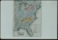
Subject (Geographic):
West (U.S.)--Maps
Subject (Topic):
Indian reservations--Maps and Indians--Languages--Maps
Also shows Amerindian reservations: Cayuga Reservation -- Onondago Reservation -- Oneida Reservation., Imperfect: mutilated. Backed with paper., Includes note describing the numbering of military-township lots., and Shows property tract boundaries, town (militar
Publisher:
[publisher not identified],
Subject (Geographic):
New York (State)--Administrative and political divisions--Maps--Early works to 1800, New York (State)--Upstate New York, and Upstate New York (N.Y.)--Administrative and political divisions--Maps--Early works to 1800
Subject (Name):
Tiebout, Cornelius, 1777-1832
Subject (Topic):
Administrative and political divisions, Indian reservations--New York (State)--Maps--Early works to 1800., Landowners--New York (State)--Maps--Early works to 1800., and Landowners--New York (State)--Upstate New York--Maps--Ear
Forty miles around New York., H.H. Lloyd's new map of the great metropolis., H.H. Lloyd's New-York and forty miles around it., New map of the great metropolis., and New-York and forty miles around it.
Description:
Includes lists of maps published by the company (on map) and Relief shown by hachures.
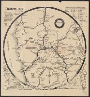
Grants Pass highway map, Grants Pass, Josephine County, Oregon, and Official highway map
Description:
Copyright: J.R. Harvey, Grants Pass, Oregon., Includes distance table, ancillary map of Pacific (6th) Highway area in Grants Pass, location map, and text., Relief shown by hachures and pictorially., and Text and photos on verso.