Search
You Searched For
Search Results
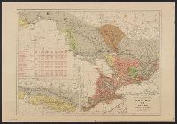
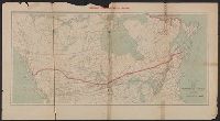
- Creator:
- Canada. Dept. of the Interior
- Published / Created:
- 190-?]
- Call Number:
- 73gme 1912A
- Container / Volume:
- BRBL_00376
- Image Count:
- 2
- Resource Type:
- Maps, Atlases & Globes
- Found in:
- Beinecke Rare Book and Manuscript Library > Atlas of Canada : Railways.
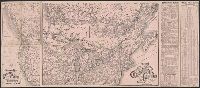
- Creator:
- Burr, Henry A
- Published / Created:
- 1853
- Call Number:
- 75GM 1853
- Container / Volume:
- BRBL_00410
- Image Count:
- 1
- Resource Type:
- Maps, Atlases & Globes
- Found in:
- Beinecke Rare Book and Manuscript Library > Disturnell's new map of the United States and Canada : showing all the canals, rail roads, telegraph lines and principal stage routes / Drawn by Henry A. Burr.
- Creator:
- Middleton, Strobridge & Co
- Published / Created:
- [1857].
- Call Number:
- 753gme 1858
- Container / Volume:
- BRBL_00415
- Image Count:
- 1
- Resource Type:
- Maps, Atlases & Globes
- Found in:
- Beinecke Rare Book and Manuscript Library > Map illustrating the Canada Pacific and Northern Pacific and other proposed Railroads, connecting at Straits of Mackinaw : Also showing the position of Mackinaw City.
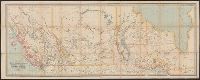
- Creator:
- Dawson Brothers
- Published / Created:
- 1882
- Call Number:
- 73 1882
- Container / Volume:
- BRBL_00375
- Image Count:
- 1
- Resource Type:
- Maps, Atlases & Globes
- Found in:
- Beinecke Rare Book and Manuscript Library > Map of Manitoba, Kewaydin, British Columbia and North West Territory : shewing the country traversed by the Canadian Pacific Railway.
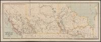
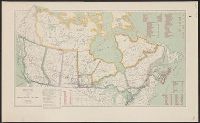
- Creator:
- Dawson Brothers
- Published / Created:
- 1880
- Call Number:
- 73 1880
- Container / Volume:
- BRBL_00375
- Image Count:
- 1
- Resource Type:
- Maps, Atlases & Globes
- Found in:
- Beinecke Rare Book and Manuscript Library > Map of Manitoba, Kewaydin, British Columbia and North West Territory : shewing the country traversed by the Canadian Pacific Railway.
- Creator:
- Canadian Pacific Railway Company
- Published / Created:
- 1889]
- Call Number:
- 73gme 1889
- Container / Volume:
- BRBL_00376
- Image Count:
- 2
- Resource Type:
- Maps, Atlases & Globes
- Found in:
- Beinecke Rare Book and Manuscript Library > Map of the Canadian Pacific Railway and its connections.
- Creator:
- Poole Brothers
- Published / Created:
- [1927], c1911.
- Call Number:
- 73gme 1927
- Container / Volume:
- BRBL_00376
- Image Count:
- 1
- Resource Type:
- Maps, Atlases & Globes
- Found in:
- Beinecke Rare Book and Manuscript Library > Map of the Canadian Pacific Railway, the Minneapolis, St. Paul & Sault Ste. Marie Railway, the Duluth, South Shore & Atlantic Railway, the Spokane International Railway and connections / Poole Bros, Chicago.
- Creator:
- Poole Brothers
- Published / Created:
- [1901?], c1893.
- Call Number:
- 73eu 1901
- Container / Volume:
- BRBL_00375B
- Image Count:
- 1
- Resource Type:
- Maps, Atlases & Globes
- Found in:
- Beinecke Rare Book and Manuscript Library > Map of the Canadian Pacific Railway, the Minneapolis, St. Paul and Sault Ste. Marie Railway, the Duluth, South Shore and Atlantic Railway and connections / Poole Bros, engravers.
- Creator:
- White, James, 1863-1928
- Published / Created:
- 1904
- Call Number:
- 73gme 1904
- Container / Volume:
- BRBL_00376
- Image Count:
- 1
- Resource Type:
- Maps, Atlases & Globes
- Found in:
- Beinecke Rare Book and Manuscript Library > Map of the Dominion of Canada / James White, F.R.G.S., geographer.
- Creator:
- White, James, 1863-1928
- Published / Created:
- [1908]
- Call Number:
- 73 1908
- Container / Volume:
- BRBL_00375A
- Image Count:
- 1
- Resource Type:
- Maps, Atlases & Globes
- Found in:
- Beinecke Rare Book and Manuscript Library > Map of the Dominion of Canada / James White, geographer.