Inset: The sea coasts of Great Britain and Ireland. Scale approximately 1:4,500,000., Originally printed on 4 sheets., Relief shown pictorially., Robert Sayer traded alone & at this address 1751-1774 and 1783-1792 (cf. Maxted, p. l99)., Shows boundaries, rivers, lochs, roads with distances, woods and settlements., and Title cartouche depicts engraved stone, cow, and reclining figure holding a peat spade.
Publisher:
Printed for Robt. Sayer, opposite Fetter Lane, Fleet Street,
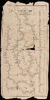
A textual note at upper left reads "The Course of the Ohio or Alliganey River and its Branches are laid down from Surveys and Draughts made on the Spot by M.r Gist and others in the Years 1751, 2, 3 & 4". and Cartouche designed by Francis Hayman and engraved
Publisher:
Thomas Jefferys,
Subject (Geographic):
Maryland--Maps--Early works to 1800., Middle Atlantic States--Maps--Early works to 1800., and Virginia--Maps--Early works to 1800.
Subject (Name):
Byrd, William, 1674-1744., Churton, William, 1710-1767, surveyor., Dalrymple, John, -1766, surveyor., Dandridge, William, -1743., Fitzwilliam, Richard, -1744., and Fry, Joshua, approximately 1700-1754, ca
New and accurate map of Germany including the seat of war in the Kingdom of Prussia, Bohemia, Lusatia, Silesia, Saxony, Westphalia
Description:
Prime meridian: London. Coordinates converted by cataloger to express longitude as measured from the Greenwich meridian., Printed on cloth., and Relief shown pictorially.
New and accurate map of Negroland and the adjacent countries
Description:
Includes decorative title cartouche with figures., Prime meridian: London, Relief shown pictorially., Shows boundaries, rivers, and principal settlements, with tents showing areas inhabited by nomads., and Watermark.
Copy 2: Imperfect: two southern sheets wanting. Borders hand colored. Dissected and mounted on linen, 50 x 115 cm. Stamp on verso, "Yale University Library, Karpinski-Von Wieser Map Collection.", Copy 2: Watermarks. Borders hand colored. Stamp on verso of northern sheets: 34. Stamp on verso of southern sheets: 35. Manuscript annotations in 20th century hand on verso of northern sheets., Insets: A particular map of Baffin and Hudson's Bay -- The passage by land to California., Prime meridians: London and Ferro., and Relief shown pictorially.
Publisher:
Publish'd by Laurie & Whittle, No. 53 Fleet Street,
Copy 1: two northern sheets joined and two southern sheets joined. Borders hand colored. Stamps, "Yale, Horace Brown, 1900S.", Copy 1: Watermarks. Borders hand colored. Stamp on verso of northern sheets: 62. Stamp on verso of southern sheets: 63., Insets: A particular map of Baffin and Hudson's Bay -- The passage by land to California., Prime meridians: London and Ferro., and Relief shown pictorially.
Publisher:
Publish'd by Laurie & Whittle, No. 53 Fleet Street,
Copy 3: Interiors hand colored. Stamp on verso of northern sheets: 37. Stamp on verso of southern sheets: 38., Insets: A particular map of Baffin and Hudson's Bay -- The passage by land to California., Prime meridians: London and Ferro., and Relief shown pictorially.
Publisher:
Publish'd by Laurie & Whittle, No. 53 Fleet Street,
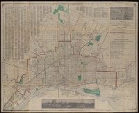
"Engraved according to act of Congress in the year 1842 by Saml. B. Munson ...", Imperfect: torn along folds, with some loss of text. Removed from the Roger Sherman papers., Includes distance table., and Orientation of rivers varies.
Publisher:
Published by Geo. Conclin,
Subject (Geographic):
Illinois River--Maps., Mississippi River--Maps., Missouri River--Maps., and Ohio River--Maps.