

- None7
You Searched For
« Previous
| 21 - 26 of 26 |
Next »
Search Results

- Creator:
- Ram, Johannes de, 1648-1693, printmaker
- Published / Created:
- [approximately 1690]
- Call Number:
- 724 690R
- Image Count:
- 59
- Resource Type:
- still image
- Abstract:
- Views of Rome (including the Vatican City), London, Amsterdam, and Tangier
- Description:
- All engraved. and Bound in full contemporary calf, spine gilt, red morocco label. For further information, consult library staff.
- Publisher:
- publisher not identified
- Subject (Geographic):
- London (England), Rome (Italy), Amsterdam (Netherlands), and Vatican City
- Found in:
- Lewis Walpole Library > Voornaamste gebouwen vande stadt Romen t'Amsterdam
- Published / Created:
- [early 20th century]
- Call Number:
- GEN MSS 1486 (Oversize)
- Container / Volume:
- Box (Oversize)
- Image Count:
- 2
- Resource Type:
- still image
- Abstract:
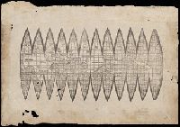
- A photomechanical print probably created during the early twentieth century as a forgery that reproduces twelve gores for a globe published in 1507 by Martin Waldseemüller based on his wall map, Universalis Cosmographia (1507). and Evidence of the forgery includes the superimposition of the gores over glue already on the paper surface, which suggests use of a sheet removed from a period volume, as well as details that replicate gores from an authentic woodcut print formerly owned by Austrian cartographer Franz Hauslab and acquired by the James Ford Bell Library at the University of Minnesota in 1954
- Description:
- A gore is a roughly triangular or wedge-shaped segment of an object, as found in domes and globes, where a sector of a curved surface, or a curved surface that lies between two close lines of longitude on a globe, and flattened to a plane surface with little distortion., Martin Waldseemüller (1470-1519) was a German cartographer. His wall map Universalis Cosmographia (1507) and printed globes contemporarily derived from it were the first published globular maps of the Western Hemisphere and the first maps on which the name America appears in honor of Italian explorer Amerigo Vespucci (1454-1512)., In Latin., Title devised by cataloger., and Publication place and date of creation supplied by the cataloger.
- Subject (Geographic):
- America
- Subject (Name):
- Hauslab, Franz, 1798-1883., Vespucci, Amerigo, 1451-1512., and Waldseemüller, Martin, 1470-1519
- Subject (Topic):
- Forgeries, Globes, World maps, Discovery and exploration, and Name
- Found in:
- Beinecke Rare Book and Manuscript Library > [Globe gores forgery after Martin Waldseemüller].
- Published / Created:
- [not after 1624]
- Call Number:
- Lanman 5626 1624
- Image Count:
- 1
- Resource Type:
- cartographic image
- Alternative Title:
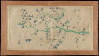
- Map of Yuanzhou Fu, Jiangxi Province : prefecture and 3 counties
- Description:
- Title supplied by cataloger., Mounted on dull gold damask., and Covers three counties: Yichun Xian, Wanzai Xian, Fenyi Xian.
- Publisher:
- publisher not identified
- Subject (Geographic):
- Yichun (Jiangxi Sheng, China), Wanzai Xian (China), and Fenyi Xian (China)
- Subject (Topic):
- Maps
- Found in:
- Beinecke Rare Book and Manuscript Library > [Jiangxi Yuanzhou Fu tu]., [江西袁州府圖].
- Published / Created:
- [approximately 1679]
- Call Number:
- Globe 41
- Image Count:
- 11
- Resource Type:
- cartographic three dimensional form
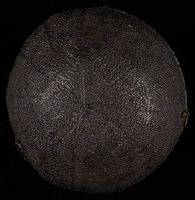
- Description:
- BEIN Globe 41: From the library of Stephen F. Gates. Accompanied by display plate., Title devised by cataloger., In a spherical case with a celestial planisphere on the interior., and The globe shows the tracks of the circumnavigations of Sir Francis Drake 1577-80, and Thomas Cavendish 1586-88.
- Publisher:
- Sumptibus J. Moxon
- Subject (Geographic):
- Earth (Planet)
- Subject (Name):
- Drake, Francis, approximately 1540-1596 and Cavendish, Thomas, 1555?-1592
- Subject (Topic):
- Travel, Maps, and Constellations
- Found in:
- Beinecke Rare Book and Manuscript Library > [Pocket terrestrial globe] [cartographic material].

- Creator:
- Volčić, Vicko Dimitrije, 1563-1607, cartographer
- Published / Created:
- [1601]
- Call Number:
- Manuscript 49cea 1601
- Image Count:
- 2
- Resource Type:
- cartographic image
- Description:
- Title devised by cataloger., "Vinc[enti]us demetrei Volcius Rachuseus. Fecit interra Liiburni die 24 Maius 1601.", With blue cloth tie at left edge., Color: red, blue, and some gold., With four compass roses., and Coordinates not present on map and are approximated.
- Subject (Geographic):
- Mediterranean Sea
- Subject (Topic):
- Nautical charts
- Found in:
- Beinecke Rare Book and Manuscript Library > [Portolan chart of the Mediterranean Sea].