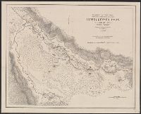
Insets: Alaska -- Philippine Islands -- Tutuila Group of the Samoan Islands -- Manua -- Guam or Cuajan Island -- Hawaiian Islands -- Porto Rico -- Panama Canal -- Isthmus of Panama showing location of canal. and Relief shown by hachures.
Publisher:
Dept. of the Interior, General Land Office,
Subject (Geographic):
United States--Discovery and exploration--Maps and United States--Maps
Subject (Name):
Bond, Frank, 1856-1940 and United States. General Land Office
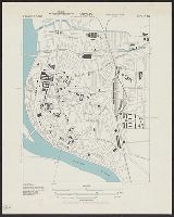
"Surveyed in 1888-91, 1896, and 1906-1907." and On verso: Jamestown Exposition on Hampton Roads, Virginia : plan of exposition grounds and buildings : progress map, June 1st 1907 / made by W.R. Kelly ; copyright applied for by Jamestown Exposition Co. Scale [ca. 1:6,800]
Publisher:
U.S. Geological Survey,
Subject (Geographic):
Hampton Roads (Va. : Harbor)--Maps, Norfolk Metropolitan Area (Va.)--Maps, Norfolk Metropolitan Area (Va.)--Maps, Topographic, and Norfolk Region (Va.)--Maps, Topographic
Subject (Name):
Jamestown Exposition Co, Jamestown Ter-centennial Exposition--(1907)--Maps, Kelly, W. R. Jamestown Exposition on Hampton Roads, Virginia, and U.S. Coast and Geodetic Survey
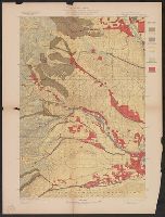
"Engraved Apr. 1901 by Julius Bien & Co.", "Surveyed in 1897-98.", Plate CXXXIII from the "Twenty-first annual report" of the U.S. Geological Survey, Part 5, Forest reserves (1900)., Relief shown by contours and spot heights., and Shows five classes of land cover.
Publisher:
The Survey,
Subject (Geographic):
Chelan County (Wash.)--Maps and Douglas County (Wash.)--Maps
Subject (Name):
Farmer, R. A, Geological Survey (U.S.). Annual report, Griswold, W. T, and Plummer, Fred G. (Fred Gordon), 1864-1913
Subject (Topic):
Forests and forestry--Washington (State)--Chelan County--Maps, Forests and forestry--Washington (State)--Douglas County--Maps, Forests and forestry--Washington (State)--Okanogan County--Maps, and Land capability for agricultur
"Julius Bien & Co. Lith. N.Y.", "Surveyed in 1899.", Plate CXXXII from the "Twenty-first annual report" of the U.S. Geological Survey, Part 5, Forest reserves (1900)., Relief shown by contours and spot heights., and Shows five classes of land cover.
Publisher:
The Survey,
Subject (Geographic):
Yakima County (Wash.)--Maps
Subject (Name):
Geological Survey (U.S.). Annual report, Murlin, A. E, and Plummer, Fred G. (Fred Gordon), 1864-1913
Subject (Topic):
Forests and forestry--Washington (State)--Kittitas County--Maps, Forests and forestry--Washington (State)--Yakima County--Maps, Kittitas County (Wash.)--Maps, and Land capability for agriculture--Washington (State)--Kittitas C