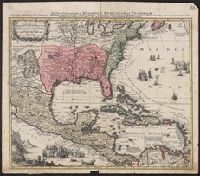
Mappa Aestivarvm insularum, alias Barmvdas dictarum
Description:
Below map, list of proprietors in 12 columns flanked by coats-of-arms., Borders are hand colored., and Not hand colored. With watermark. Sheet measures 46 x 55 cm.
Manuscript number in upper right corner: 116., Relief shown pictorially., and Watermark.
Subject (Geographic):
Caribbean Area--Maps--Early works to 1800, Central America--Maps--Early works to 1800, Mexico--Maps--Early works to 1800, North America--Maps--Early works to 1800, and United States--Maps--Early works to 1800
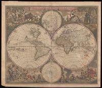
Allegorical vignettes of the four seasons., Double hemisphere, with smaller polar insets., Imperfect: chipped and mutilated along edges and fold, with some loss of text. Backed with paper., Relief shown pictorially., Shows California as an island., and State 2, in which cherubs were placed in the cusps and a border added; see Rodney Shirley, Mapping of the world, entry 451.
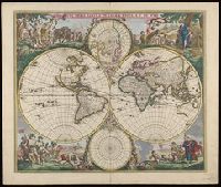
Allegorical vignettes of the four seasons., Double hemisphere, with smaller polar insets., Label on verso with manuscript number "101/61." Manuscript notes on verso: A.K. 481; no. 3; de Wit, 1660 [crossed out] 1677. Cross collection no. 26., Relief shown pictorially., Shows California as an island., and State 2, in which cherubs were placed in the cusps and a border added; see Rodney Shirley, Mapping of the world, entry 451.
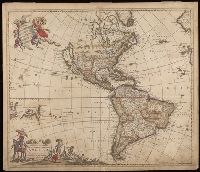
"Cum Privilegio D.D. Ordinum Holl. Westfriliegs.", According to P.D. Burden, Mapping of North America, this is the seventh state of de Wit's map of America, with a new title engraved adding the privilege statement, lower case letters inserted between the latitude numbers and upper case letters between the longitude, and the longitudinal line 338° bearing a bad plate crack in the souther hemipshere, with an erased compass rose at the junction of 338° longitude and 10° north latitude., Appears in various editions of Wit's Atlas., Baked with paper., Number "2" in upper right corner., Prime meridian: Ferro., Relief shown pictorially., and Watermark.
Subject (Geographic):
America--Maps--Early works to 1800. and Western Hemisphere--Maps--Early works to 1800.
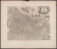
Coordinates not present on map and are approximated., From Joan Blaeu's Atlas maior (1662)., Latin text on verso; paginated ij-j, with caption Belgica., Relief shown pictorially., and With north oriented towards the upper right.
Subject (Geographic):
Netherlands--Maps--Early works to 1800
Subject (Name):
Blaeu, Joan, 1596-1673. Atlas maior, Ende, Josua van den, approximately 1584-approximately 1634, engraver, and Typographia Blaviani