Great Britain. War Office. General Staff. Geographical Section
Published / Created:
1919?]
Call Number:
434fd 1919
Container / Volume:
BRBL_00251
Image Count:
1
Resource Type:
Maps, Atlases & Globes
Alternative Title:
Czecho-Slovakia
Description:
"G.S.G.S. No. 2758.", "S.G.A. 2.4.19.", Also shows portions of Germany, Poland, Austria, Hungary, and Romania., In French and English., Relief shown by contours and spot heights., and Shows proposed boundaries and roads.
Publisher:
G.S.G.S.,
Subject (Geographic):
Czechoslovakia--Boundaries--Maps and Czechoslovakia--Maps
Great Britain. War Office. General Staff. Geographical Section
Published / Created:
1940
Call Number:
342 1944
Container / Volume:
BRBL_00092
Image Count:
2
Resource Type:
Maps, Atlases & Globes
Alternative Title:
G.S.G.S. ; 4139 and GSGS (Series) ; 4139.
Description:
Contents: North sheet -- South sheet., Contours at 50 meters interval., Copied from a Danish map of 1932., Four classes of roads are shown., and Military grid.
Great Britain. War Office. General Staff. Geographical Section
Published / Created:
1927
Call Number:
BrSides Folio 2018 131
Image Count:
1
Resource Type:
Maps, Atlases & Globes
Alternative Title:
GSGS (Series) ; 3857
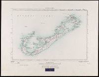
Description:
"250/27.", "Surveyed in 1898-99.", Bookseller's label at bottom of sheet: International Map Company, Inc. ... New York. N.Y., Relief shown by spot heights (in feet)., and Shows roads (2 categories) and parish boundaries.
Publisher:
Ordnance Survey Office,
Subject (Geographic):
Bermuda Islands--Maps.
Subject (Name):
Great Britain. Ordnance Survey and International Map Company
Great Britain. War Office. General Staff. Geographical Section
Published / Created:
1943
Call Number:
408 Ag84 1943
Container / Volume:
BRBL_00239
Image Count:
1
Resource Type:
Maps, Atlases & Globes
Alternative Title:
Geographical Section, General Staff ; no. 4379, GSGS (Series) ; 4379., and Italy 1:5,000
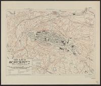
Description:
"5-43.", "Enlarged, "Published by the War Office, 1942, 2nd edition, 1943.", A few important streets are named., Also shows power lines, railways, and aquaducts., Includes index to buildings., Military grid., and Relief shown by contours, hachures, and spot heights.
Great Britain. War Office. General Staff. Geographical Section
Published / Created:
1943
Call Number:
40 Ao75 1943
Container / Volume:
BRBL_00204
Image Count:
1
Resource Type:
Maps, Atlases & Globes
Alternative Title:
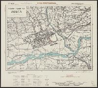
Geographical Section, General Staff ; no. 4380, GSGS (Series) ; 4380., and Italy
Description:
"12/42/G.S.G.S.", "2-43.", "Authorities, carta d'Italia 1:25,000 1930 ... various guide book plans.", "Published by War Office, 1942.", Important streets and buildings are named., Military grid., and Relief shown by form lines, hachures, and spot heights.