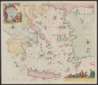
"Met priviligie voor 15 Iaar.", Appears in the author's De groote niewe vermeerderde zee-atlas ofte water-waereld., Dutch, with Latin place names., Has watermark., and Includes col. ill., decorative cartouche, and rhumb lines.
Publisher:
By Ioannes van Keulen, boeck verkooper en graad boogh maker, aen de N:Brugh inde gekroonde Loots,
Subject (Geographic):
Aegean Islands (Greece and Turkey)--Maps--Early works to 1800 and Crete (Greece)--Maps--Early works to 1800
Subject (Name):
Keulen, Johannes van, 1654-1715. Groote nieuwe vermeerderde zee-atlas ofte water-waereld
Appears in various Dutch eds. of Blaeu's Theatrum orbis terrarum., Bar scales in "Miliaria Germanica communia" and "Miliaria Gallica communia.", In Dutch on verso, with caption title "Peru" and signature Y., Oriented with north to the left., Relief shown pictorially., and Sheet measures 47.3 x 61.4 cm.
Publisher:
Guiljelmus Blaeuw excudit,
Subject (Geographic):
Peru--Maps--Early works to 1800
Subject (Name):
Blaeu, Willem Janszoon, 1571-1638. Theatrum orbis terrarum. Dutch
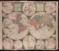
Vlakke aard-kloot gemeenlyk genaamd de geheele waereld
Description:
Backed with paper. Sheet measures 53.6 x 61.9 cm. No. 1 of 87 maps bound together., Includes twelve ancillary maps., Relief shown pictorially., Scale determined by using graticule method., and Watermark.
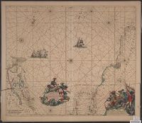
Terra Neuf, en de custen van Nieu Engeland, Nieu Nederland, Nieu Andalusia, Guiana en Venezuela
Description:
Covers the Atlantic Ocean west of the Azores and Cape Verde Islands, and the coasts of northeastern North America and northern South Amerca., Fr, In Latin and Dutch., Includes two decorative cartouches and ill., North oriented to left., and With "22" at top right.
Publisher:
Gedruckt by Fredrick de Wit in de Kalverstrae,
Subject (Geographic):
Atlantic Provinces--Maps--Early works to 1800 and North Atlantic Ocean--Maps--Early works to 1800
Subject (Name):
Wit, Frederik de. Orbis Maritimus ofte Zee Atlas
Subject (Topic):
Nautical charts--Atlantic Ocean--Early works to 1800
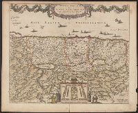
"20" in upper right corner., Along the top of the map is a garland supported by a cherubim; at bottom center, the encapment of the tribes flanked by Moses and Aaron is pictured., Appears in various editions of Wit's Atlas., Relief shown pictorially., and Sheet me
Publisher:
Gedruckt tot Amsterdam by Frederick de Wit in de Calverstraet by den Dam inde Witte Paskaert,
Subject (Geographic):
Palestine--History--To 70 A.D.--Maps and Palestine--Maps--Early works to 1800
Terra neuf, en de custen van Nieu Vranckryck, Nieu Engeland, Nieu Nederland, Nieu Andalusia, Guiana en Venezuela
Description:
At upper right corner: Fol. 26., Covers the Atlantic Ocean west of, From Renard's Atlas de la navigation et du commerce ... Amsterdam : Chez Louis Renard, 1715., In Latin and Dutch., Includes two decorative cartouches and ill., and Oriented with north to the left.
Publisher:
Gedruckt by L. Renard,
Subject (Geographic):
North Atlantic Ocean--Maps--Early works to 1800
Subject (Name):
Renard, Louis. Atlas de la navigation et du commerce
Subject (Topic):
Nautical charts--North Atlantic Ocean--Early works to 1800
Terra neuf, en de custen van Nieu Vranckryck, Nieu Engeland, Nieu Nederland, Nieu Andalusia, Guiana en Venezuela
Description:
Covers the Atlantic Ocean west of the Azores and Cape Verde Islands, and the coasts of northeastern North America and northern South Amerca., In Latin and Dutch., Includes two decorative cartouches and ill., Ms. "25" in upper right margin., and Oriented with nort
Publisher:
Gedruckt by Fredrick de Wit in de Kalverstraet,
Subject (Geographic):
North Atlantic Ocean--Maps--Early works to 1800
Subject (Topic):
Nautical charts--North Atlantic Ocean--Early works to 1800
Charts and title pages in English, text in Dutch., Map oriented with North at bottom left., and Volvelle on p. [17].
Publisher:
Jodocus Hondius excudit,
Subject (Geographic):
Europe --Maps --Early works to 1800, Great Britain --Maps --Early works to 1800, Netherlands --Maps --Early works to 1800, and North Sea --Maps --Early works to 1800
Afheeldinghe der custen des landts Guinea, Manicongo, ende Angôla, ende voorts tot voorby de C. de boa esperança and Delineatio orarum maritimarum, terrae vulgo indigetatae terra do Natal item Sofalae, Mozambicae & Melindae ...
Description:
Appears in the author's, Companion map to Delineatio orarum maritimarum, terrae vulgo indigetatae terra do Natal item Sofalae, Mozambicae & Melindae ..., Has watermark., Relief shown pictorially., and Title in Latin and Dutch. Place names in Latin and Portuguese.
Publisher:
Arnold Florent van Langren,
Subject (Geographic):
Africa, Southern--Maps--Early works to 1800
Subject (Name):
Langren, Arnold Florent van, 1580-1644 and Linschoten, Jan Huygen van, 1563-1611. Itinerario, voyage ofte schipvaert van Jan Huygen van Linschoten naer Oost ofte Portugaels Indien
Subject (Topic):
Coasts--Africa, Southern--Maps--Early works to 1800
Afheeldinghe der custen des landts Guinea, Manicongo, ende Angôla, ende voorts tot voorby de C. de boa esperança and Delineatio orarum maritimarum, terrae vulgo indigetatae terra do Natal item Sofalae, Mozambicae & Melindae ...
Description:
Appears in the author's Itinerario, voyage ofte schipvaert van Jan Huygen van Linschoten naer Oost ofte Portugaels Indien., Includes views of Ascension Island and Sain, Relief shown pictorially., and Title in Latin and Dutch. Place names in Latin and Portuguese.
Publisher:
Arnold Florent van Langren,
Subject (Geographic):
Africa, Southern--Maps--Early works to 1800
Subject (Name):
Langren, Arnold Florent van, 1580-1644 and Linschoten, Jan Huygen van, 1563-1611. Itinerario, voyage ofte schipvaert van Jan Huygen van Linschoten naer Oost ofte Portugaels Indien
Subject (Topic):
Coasts--Africa, Southern--Maps--Early works to 1800