At head of title: Australia Gulf of Carpentaria., Coordinates not present on map and are approximated., In lower right corner: 1708., and Soundings in fathoms.
Publisher:
Hydrographic Office of the Admiralty,
Subject (Geographic):
Queensland.
Subject (Name):
Bate, R. B. (Robert Brettell), bookseller., Great Britain. Hydrographic Office, publisher., and J. & C. Walker (Firm), engraver.
Subject (Topic):
Albert River (Qld.)--Maps., Albert River (Qld.)--Navigation--Maps., and Nautical charts--Australia--Queensland.
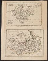
"Engrav'd for Jackson's Edition of Payne's new System of Universal Geography"--Bottom margin., Bar scales given in “English miles 69 to a degree” and "German miles 15 to a degree.”, From John Payne's Universal geography formed into a new and entire system (Dublin: Zachariah Jackson, 1792-1794), or later edition., Includes index., No. 1 of 2 maps mounted on same sheet., Prime meridian: London. Coordinates converted by cataloger to express longitude as measured from the Greenwich meridian., and Relief shown pictorially.
Subject (Geographic):
Bohemia (Czech Republic)--Maps--Early works to 1800.
Subject (Name):
Ferguson (Engraver), engraver., Jackson, Zachariah, printer., and Payne, John, active 1800. Universal geography formed into a new and entire system.
"Compiled and engraved from government surveys and original information.", "Copyright 1905, F.S. Blanchard & Co., Worcester, Mass.", Electric railway routes and proposed routes printed in orange., Includes: Index to towns and population, U.S. census 1900 and Mass. state census, 1905., Prime meridian: Greenwich., Shows roads, railroads, proposed and existing electric railways and post offices., and Table: Distances by rail, generally travelled routes. Includes distances between the larger cities and towns of New England.
Publisher:
Home Educator Co.,
Subject (Geographic):
New England--Maps.
Subject (Name):
F.S. Blanchard & Co.
Subject (Topic):
Electric railroads--New England--Maps. and Railroads--New England--Maps.
"Entered according to act of Congress, in the year 1853, by J.H. Colton, in the Clerks Office of the District Court of the United States for the Southern District of New York.", Prime meridians: Greenwich and Washington., Relief shown by hachures., and Shows state boundaries, major cities and towns, railroads, canals, military outposts, Indian tribal areas, "Indian Territory," the western territories of the United States, and Virginia as one state.
Publisher:
Published by J.H. Colton & Co., No. 172 William St.,
Subject (Geographic):
Indian Territory--Maps, Oklahoma --Maps, and United States--Maps
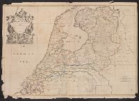
"Humbly dedicated to Elihu Yale, esq., of Place Grove in Denbyshire by his obliged humble servants, Cha. Price, Ion. Senex, Ion. Maxwell, Geographers to the Queen.", Imperfect: chipped along edges, with some loss of text. Mounted on cardboard., and Relief shown pictorially.
Publisher:
[John Senex],
Subject (Geographic):
Netherlands--Maps--Early works to 1800.
Subject (Name):
Maxwell, John, active 1708-1712, dedicator., Price, Charles, active 1700-1707, dedicator., and Yale, Elihu, 1649-1721, dedicatee.
"Humbly dedicated to Elihu Yale, esq., of Place Grove in Denbyshire by his obliged humble servant, Ion. Senex, F.R.S.", Imperfect: brittle and chipped, with no loss of text. Cross collection 76., and Relief shown pictorially.