Harbour of Annapolis Royal, Indian fort Sasquesahanok, and Map of ye mouth of Mississipi and Mobile rivers &c
Description:
Appears in Moll's The world described., Blocks of text offer explanations of various features of the map., Includes notes and ill. of "The Indian Fort Sasquesahanok.", Label, with ms. nos., on verso: 533/9. Hand col. Sheet measures, and Relief shown pictorially.
Publisher:
Sold by H. Moll over against Devereus Court between Temple Bar and St. Clements Church in the Strand ... [and] sold by Tho: Bowles ... Iohn King ... Iohn Bowles,
Subject (Geographic):
North America--Maps--Early works to 1800
Subject (Name):
Bowles, John, 1701-1779, bookseller, Bowles, Thomas, -1767, bookseller, and Moll, Herman, -1732. World described
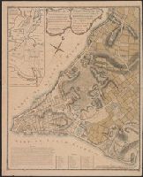
Harbour of Annapolis Royal, Indian fort Sasquesahanok, and Map of ye mouth of Mississipi and Mobile rivers &c
Description:
Appears in Moll's The world described., Blocks of text offer explanations of various features of the map., Dedicated to Thomas Bromsall., Includes notes and ill. of "The Indian Fort Sasquesahanok.", and Insets: The harbour of Annapolis Royal -- A map of ye mouth
Publisher:
Sold by H. Moll over against Devereus Court between Temple Bar and St. Clements Church in the Strand ... [and] sold by Tho: Bowles ... Iohn King ... Iohn Bowles,
Subject (Geographic):
North America--Maps--Early works to 1800
Subject (Name):
Bowles, John, 1701-1779, bookseller, Bowles, Thomas, -1767, bookseller, and Moll, Herman, -1732. World described
New song to drive away cold winter, between Robin Hood and the jovial Tinker and Robin Hood (Legend). English.
Description:
BEIN 2000 Folio 6 308: Imperfect: mutilated at edges, text wanting. Mounted to 30 x 42 cm., Place and date of publication surmised from Wing., Verse -- "In summer time when leaves grow green,"., and Wing and ESTC list several other editions of this title, but none with this printer.
Publisher:
Printed for W. Thackeray, in Duck-Lane,
Subject (Topic):
Ballads, English--England--Texts and Robin Hood (Legendary character)--Poetry--Early works to 1800
Map of Gabarus Bay adjoyning to Louisburg. and Plan of the city and harbour of Louisburg.
Description:
"Octob. 9, 1758." and Includes text, index to fortification, "The profile," and insets of "A plan of the city and harbour of Louisburg ... during the siege in 1758" and "A map of Gabarus Bay, adjoyning to Louisburg."
Publisher:
Thos. Jeffreys,
Subject (Geographic):
Louisbourg (N.S.)--Buildings, structures, etc.--Maps--Early works to 1800, Louisbourg (N.S.)--History--Siege, 1745--Maps--Early works to 1800, and Louisbourg (N.S.)--Maps--Early works to 1800
Subject (Name):
Gridley, Richard, 1711-1796
Subject (Topic):
Fortification--Nova Scotia--Louisbourg--Maps--Early works to 1800