Skip to search
Skip to main content
Skip to first result
Search
You Searched For
Format
cartographic
Genre
Lithographs
New Search
Search Results
Creator:
Call Number:
A52 030 1
Collection Title:
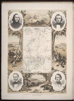
Ancient monuments of the Mississippi Valley: comprising the results of extensive original surveys
Image Count:
1
Description:
Facing p. 96.
Subject (Geographic):
Mississippi River Valley --Antiquities
Subject (Name):
Davis, E. H. (Edwin Hamilton), 1811-1888
Subject (Topic):
Mound-builders and Mounds --Mississippi River Valley
Collection Created:
[Washington, Smithsonian institution, 1848]
Found in:
Beinecke Rare Book and Manuscript Library > "The serpent;" (Entry 1014) Adams County Ohio. Pl. XXXV [35]
Creator:
Published / Created:
1854
Call Number:
Folio 296
Image Count:
1
Resource Type:
Books, Journals & Pamphlets
Description:
Hand colored map. and In double columns. In portfolio.
Publisher:
Published for the author by E. Stanford; [etc., etc.]
Subject (Geographic):
Africa, Central --Maps and Africa, Central--Description and travel
Subject (Name):
Overweg, Adolf,--1822-1852, Richardson, James,--1806-1851, and Vogel, Eduard,--1829-1856
Found in:
Beinecke Rare Book and Manuscript Library > ... An account of the progress of the expedition to Central Africa, performed by order of Her Majesty's Foreign office, under Messrs. Richardson, Barth, Overweg & Vogel, in the years 1850, 1851, 1852, and 1853. Consisting of maps and illustrations, with descriptive notes, constructed and comp. from official and private materials by Augustus Petermann ...
Published / Created:
1850
Call Number:
1975 Folio 26
Collection Title:
A new universal atlas containing maps of the various empires, kingdoms, states and republics of the
Image Count:
1
Resource Type:
Maps, Atlases & Globes
Subject (Name):
P.S. Duval & Son
Collection Created:
Philadelphia, Thomas, Cowperthwait & Co., No. 253 Market street, 1852
Found in:
Beinecke Rare Book and Manuscript Library > A new map of Maine
Published / Created:
1846
Call Number:
1976 Folio 93
Collection Title:
Mitchell’s universal atlas
Image Count:
1
Resource Type:
Maps, Atlases & Globes
Subject (Geographic):
Maine
Collection Created:
Philadelphia, S.A. Mitchell, 1847, c1844
Found in:
Beinecke Rare Book and Manuscript Library > A new map of Maine
Creator:
Call Number:
Zc10 845fr
Collection Title:
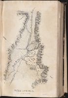
Report of the exploring expedition to the Rocky Mountains in the year 1842, and to Oregon and north
Image Count:
1
Description:
Facing p. 136.
Subject (Geographic):
Pacific States, Rocky Mountains, United States --Exploring expeditions, United States. Army. Corps of Topographical Engineers, and West (U.S.) --Description and travel
Subject (Name):
Hall, James, 1811-1898 and Torrey, John, 1796-1873
Collection Created:
Washington : Gales and Seaton, Printers, 1845
Found in:
Beinecke Rare Book and Manuscript Library > Beer Springs
Creator:
Published / Created:
[1840]
Call Number:
1973 Folio 105
Collection Title:
Atlas fisico y politico de la Republica de Venezuela ... por ... Agustin Codazzi ...
Image Count:
1
Resource Type:
Maps, Atlases & Globes
Description:
Double page width, tab mounted. and Lith. de Thierry Fres. Cite Bergere 1 a Paris, printers.
Subject (Geographic):
Bolivar (Venezuela : State), Guayana Region (Venezuela)--Maps, Orinoco River Valley (Venezuela and Colombia), and Venezuela --Maps
Subject (Topic):
Physical geography --Venezuela
Collection Created:
Caracas,
Found in:
Beinecke Rare Book and Manuscript Library > Carta del Canton de Angostura de la provincia de la Guayana
Creator:
Published / Created:
[1840]
Call Number:
1973 Folio 105
Collection Title:
Atlas fisico y politico de la Republica de Venezuela ... por ... Agustin Codazzi ...
Image Count:
1
Resource Type:
Maps, Atlases & Globes
Description:
Double page width, tab mounted. and Lith. de Thierry Fres. Cite Bergere 1 a Paris, printers.
Subject (Geographic):
Guayana Region (Venezuela)--Maps, Orinoco River Valley (Venezuela and Colombia), Upata (Venezuela)--Maps, and Venezuela --Maps
Subject (Topic):
Physical geography --Venezuela
Collection Created:
Caracas,
Found in:
Beinecke Rare Book and Manuscript Library > Carta del Canton de Upata de la provincia de la Guayana
Creator:
Published / Created:
[1887]
Call Number:
BrSides Elephant Folio Zc52 887ra
Image Count:
1
Resource Type:
Maps, Atlases & Globes
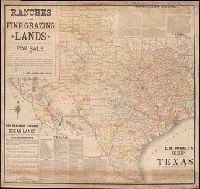
Alternative Title:
Map of the state of Texas.
Description:
Coordinates not present on map and are approximated., Imperfect: Mutilated at upper right, with some loss of text. Mounted on linen., Includes facts and figures about Texas and information about land for sale by E. M. Powell., and Relief shown by hachures.
Publisher:
Rand, McNally & Co.
Subject (Geographic):
Texas--Maps
Subject (Name):
Powell, E. M. (Ernest Malapert)
Found in:
Beinecke Rare Book and Manuscript Library > E.M. Powell's map of the state of Texas.
Published / Created:
[15--]
Call Number:
1978 Folio 106
Collection Title:
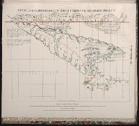
Maps of the Orinoco-Essequibo region, South America. Compiled for the Commission appointed by the
Image Count:
1
Resource Type:
Maps, Atlases & Globes
Subject (Geographic):
Amazon River--Discovery and exploration--Spanish, Amazon River--Maps, Caribbean Area--Maps--Early works to 1800, Colombia --Maps, Guyana --Maps, Orinoco River Valley (Venezuela and Colombia) --Maps, and Venezuela --Maps
Collection Created:
Washington, 1897
Found in:
Beinecke Rare Book and Manuscript Library > Early Spanish map of Guiana
Published / Created:
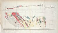
ca. 1855
Call Number:
WA Prints +4
Container / Volume:
Report of explorations for railroad routes from San Francisco Bay to Los Angeles...and from the Pimas Villages to the Rio Grande...by Lieutenant John G. Parke 1854-1855. Volume VII from Reports of explorations and surveys, to ascertain the most practicab
Image Count:
1
Found in:
Beinecke Rare Book and Manuscript Library > Geological Plan & Section from Rio Grande to the Pimas Villages along the route explored by Lieut. John G. Parke, Corps of Topl. Engrs. near the 32o north latitude. 1856. Prepared to accompany the report of Thomas Antiselol M.D. geologist of the expediti
Branch:v1.61.6 ,Deployed:2024-06-12T09:55:36-04:00