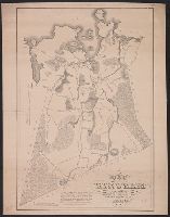
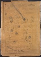
"Caution" text gives meaning of buoy colors and general rules for small craft navigation., "This map (outline) is copied from an old tracing in the possession of Mr. Wm. Puffer of Boston, Mass. It has been carefully tested by taking many cross sights ...", Bathymetry shown by spot heights., Includes area and distance statistics of lake and islands., Insets: Little Bear Isl'd thorofare -- Entrance to Lees Mills thorofare -- Entrance to Green's Basin -- Three Mile Island thorofare., Oriented with north toward the upper left., and Shows buoys, fixed lights, steamer routes, railroads and stations, post offices, sunken rocks and shoals.
Publisher:
E.N. Burwell,
Subject (Geographic):
Winnipesaukee, Lake (N.H.)--Maps and Winnipesaukee, Lake (N.H.)--Navigation--Maps