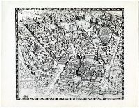
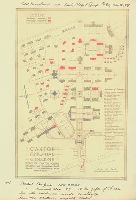
A reproduction of the architect's rendering of an aerial drawing showing Sterling Hall of Medicine and the Human Welfare Group. "A view of the Human Welfare Group. An association of institutions at New Haven, Conn, for the dealing rationally with the problems of human health in mind & body. These institutions are the Institute of Human Relations Yale Schools of Medicine & Nursing, New Haven Hospital, New Haven Dispensary, and affiliated with these are the Graduate School of Yale University, Yale School of Law, Yale Divinity School and the University's departments of instruction in all branches of science dealing with human life."
Subject (Geographic):
United States
Subject (Name):
Yale University. School of Medicine.
Subject (Topic):
Aerial views (Maps)--New Haven (Conn.), Medical colleges, and Social sciences
Northern Pacific Railway Company maps and drawings
Container / Volume:
3 (Roll) | Map 24
Image Count:
1
Resource Type:
Maps, Atlases & Globes
Abstract:
Map depicting the the region along the Kootenai and Clark Rivers, near the Montana-Idaho border. Lake Pend Oreille, Idaho is a lower left. Routes of the Great Northern and Northern Pacific railroads are shown.
Northern Pacific Railway Company maps and drawings
Container / Volume:
Box 1 | Map 36
Image Count:
1
Resource Type:
Maps, Atlases & Globes
Abstract:
Map depicting the region between the Marias River and the Canadian border, marked as British Possessions. the routes of the Great Northern and then Great Falls and Canada railroads are shown, as well as topographical detail, the "Road from Fort Benton to
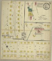
Sanborn fire insurance maps are a rich source of historic data on the urban built environment of North America during the 19th and early 20th centuries. The atlases were created for the purpose of underwriting fire insurance policies, which depended upon accurate and frequently-updated information about construction materials, municipal and transportation infrastructure, industrial and commercial landuse and more. The Yale University Library Map Department scanned its holdings of Sanborn fire insurance maps (consisting primarily of Connecticut towns) in order to make the maps more accessible.
Alternative Title:
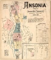
March, 1884, Ansonia, Conn.
Description:
Contains information on population, water facilities, and fire department., Includes index of streets and specials., Partial cadastral map., and SMLMAPL 766 An81 1884: Imperfect: title sheet (sheet 1) wanting. Sheets disbound. "Triplicate" stamp on all sheets.
Subject (Geographic):
Ansonia (Conn.)--Maps
Subject (Topic):
Fire risk assessment--Connecticut--Ansonia--Maps and Real property--Connecticut--Ansonia--Maps
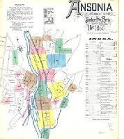
Sanborn fire insurance maps are a rich source of historic data on the urban built environment of North America during the 19th and early 20th centuries. The atlases were created for the purpose of underwriting fire insurance policies, which depended upon accurate and frequently-updated information about construction materials, municipal and transportation infrastructure, industrial and commercial landuse and more. The Yale University Library Map Department scanned its holdings of Sanborn fire insurance maps (consisting primarily of Connecticut towns) in order to make the maps more accessible.
Alternative Title:
Ansonia, Connecticut and Dec. 1890, Ansonia, Conn.
Description:
"13 sheets (4176).", Contains information on population, water facilities, and fire department., Includes index of streets and specials., Partial cadastral map., and SMLMAPL 766 An81 1890: Sheets disbound. "Triplicate" stamp on all sheets. Library of Congress copyright stamp on title sheet.
Subject (Geographic):
Ansonia (Conn.)--Maps
Subject (Name):
Library of Congress Stamp
Subject (Topic):
Fire risk assessment--Connecticut--Ansonia--Maps and Real property--Connecticut--Ansonia--Maps
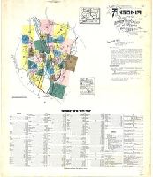
Sanborn fire insurance maps are a rich source of historic data on the urban built environment of North America during the 19th and early 20th centuries. The atlases were created for the purpose of underwriting fire insurance policies, which depended upon accurate and frequently-updated information about construction materials, municipal and transportation infrastructure, industrial and commercial landuse and more. The Yale University Library Map Department scanned its holdings of Sanborn fire insurance maps (consisting primarily of Connecticut towns) in order to make the maps more accessible.
Alternative Title:
Ansonia, Connecticut and Mar. 1924, Ansonia, Conn.
Description:
"39 sheets (1516).", Contains information on population, prevailing winds, water facilities, and fire department., Includes index of streets and specials., Partial cadastral map., and SMLMAPL 766 An81 1924: Sheets disbound.
Subject (Geographic):
Ansonia (Conn.)--Maps
Subject (Topic):
Fire risk assessment--Connecticut--Ansonia--Maps and Real property--Connecticut--Ansonia--Maps
Sanborn fire insurance maps are a rich source of historic data on the urban built environment of North America during the 19th and early 20th centuries. The atlases were created for the purpose of underwriting fire insurance policies, which depended upon accurate and frequently-updated information about construction materials, municipal and transportation infrastructure, industrial and commercial landuse and more. The Yale University Library Map Department scanned its holdings of Sanborn fire insurance maps (consisting primarily of Connecticut towns) in order to make the maps more accessible.
Alternative Title:
Baltic, Connecticut and May 1911, Baltic, Conn.
Description:
"3738, 3 sheets.", Contains information on population, prevailing winds, water facilities and fire department., Includes index of specials., Partial cadastral map., and SMLMAPL 766 B217 1911: Imperfect: sheet slightly chipped and torn, with no loss of text. Sheets disbound.
Subject (Geographic):
Sprague (Conn. : Town)--Maps
Subject (Topic):
Fire risk assessment--Connecticut--Sprague (Town)--Maps and Real property--Connecticut--Sprague (Town)--Maps
Sanborn fire insurance maps are a rich source of historic data on the urban built environment of North America during the 19th and early 20th centuries. The atlases were created for the purpose of underwriting fire insurance policies, which depended upon accurate and frequently-updated information about construction materials, municipal and transportation infrastructure, industrial and commercial landuse and more. The Yale University Library Map Department scanned its holdings of Sanborn fire insurance maps (consisting primarily of Connecticut towns) in order to make the maps more accessible.
Alternative Title:
Baltic, Conn., Jan. 1932 and Baltic, Connecticut
Description:
"(1530).", "(5 sheets).", Contains information on population, prevailing winds, water facilities and fire department., Includes index of streets and specials., Partial cadastral map., and SMLMAPL 766 B217 1932: Imperfect: sheet 1 slightly chipped, with no loss of text. Sheets disbound.
Subject (Geographic):
Sprague (Conn. : Town)--Maps
Subject (Topic):
Fire risk assessment--Connecticut--Sprague (Town)--Maps and Real property--Connecticut--Sprague (Town)--Maps