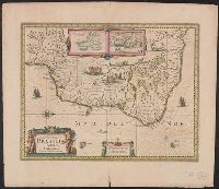
Baya de todos os Sanctos. and Villa d'Olinda de Pernambuco.
Description:
Bar scales in "Milliaria Germanica communia" and "Milliaria Gallica communia.", Cross Collection no. 339., From Hondius's Atlantis novi ... [Amsterdam] : Sumptibus & typis aeneis Henrici Hondij ..., 1638., Hand col., In Latin on verso, with caption title "Brasilia" and signature 5B., Insets: [1] Baya de todos os Sanctos -- [2] Villa d'Olinda de Pernambuco., Oriented with north to the right., Relief shown pictorially., and Shows the coast of Brazil from San Marcos bay to modern Curityba.
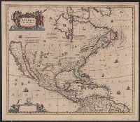
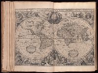
Includes col. ill. of ships, monsters, etc., Possibly from the 1639, 1641, or 1642 ed. of the author's Noveau theatre du monde ou nouvel atlas, or from the 1646, 1647, or 1649 ed. of J. Jansson's Nouvel atlas ou theatre du monde., and Relief shown pictorially.
From Jansonius's and Hondius's Atlas novus ... Amstelodami : Apud Ionnem Ianssonium & Henricum Hondium, 1638., Hand col. Mounted on linen. Sheet measures 50.6 x 58.4 cm. Cross collection no., Latin text on verso; with signature 4O., and Relief shown pictorially.
Publisher:
s.n.,
Subject (Geographic):
North America--Maps--Early works to 1800
Subject (Name):
Hondius, Hendrik, 1597-1651. Atlas novus and Jansson, Jan, 1588-1664. Atlas novus
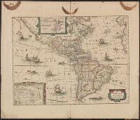
Appears in various eds. of Jan Jansson's Nouvel atlas., French text on verso., Includes ill. of ships and sea monsters, and insets showing "Polus Arcticus" region and "Terra Australis inc, and Sheet measures 50 x 59 cm. Stamp on verso: Yale, Horace Brown, 1900S.
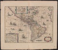
From Janssonius's and Hondius's Atlas novus ... Amstelodami : Apud Ionnem Ianssonium & Henricum Hondium, 1638., Hand col. Sheet measures 50.7 x 58.1 cm. Cross Collection no. 117., Latin text on verso., and Two polar insets.
Publisher:
Henry Hondius,
Subject (Geographic):
Western Hemisphere--Maps--Early works to 1800
Subject (Name):
Hondius, Hendrik, 1597-1651. Atlas novus and Jansson, Jan, 1588-1664. Atlas novus
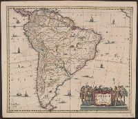
Cross Collection no. 321., From Gerardi Mercatoris atlantis novi ... Amsterodami : Sumptibus & typis aenis Henrici Hondij, 1638., In Latin on verso, with caption title "Descriptio Americae meridionalis" and signature 4Y., and Relief shown pictorially.
Publisher:
Sumptibus Henrici Hondy,
Subject (Geographic):
South America--Maps--Early works to 1800
Subject (Name):
Hondius, Hendrik, 1597-1651 and Mercator, Gerhard, 1512-1594. Atlas
At head of title: Gerardi Mercatoris et I. Hondii., Engraved t.-p., and The paging is irregular, because many maps were inserted with the same page numbering as the preceding map.
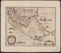
Bar scales i, Cross Collection no. 348., From Jan Jansson and Henrik Hondius's Atlas novus ... Amstelodami : Apud Ionnem Ianssonium & Henricum Hondium, 1638., Hand col., Oriented with north to the left., and Relief shown pictorially.
Publisher:
Henricus Hondius excudit,
Subject (Geographic):
Chile--Maps--Early works to 1800
Subject (Name):
Hondius, Hendrik, 1597-1651. Atlas novus and Jansson, Jan, 1588-1664. Atlas novus
[Atlas factice of 96 maps by Blaeu, Visscher, Jansson, Hondius and others]
Image Count:
1
Description:
Imperfect: holes along folds, with some loss of text; edges reinforced with ms. waste. Sheet measures 38.7 x 49.7 cm. No. 71 of 92 maps bound together. and Numbered 77 on verso.
Publisher:
Henricus Hondius excudit
Subject (Geographic):
Saxony-Anhalt (Germany) --Maps --Early works to 1800
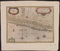
Bar scales in "Miliaria Germanica communia" and "Miliaria Gallica communia.", From Jan Jansson and Henrik Hondius's Atlas novus ... Amstelodami : Apud Ionnem Ianssonium & Henricum Hondium, 1638., In Latin on verso, with caption title "Freti Magellanici et freti le Marii descriptio" and signature 5F., and Relief shown pictorially.
Publisher:
Hendrik Hondius,
Subject (Geographic):
Magellan, Strait of (Chile and Argentina)--Maps--Early works to 1800
Subject (Name):
Hondius, Hendrik, 1597-1651. Atlas novus and Jansson, Jan, 1588-1664. Atlas novus