Search
You Searched For
Search Results
- Creator:
- Bien, Joseph R
- Published / Created:
- 1902
- Call Number:
- 766 1902
- Container / Volume:
- BRBL_00467
- Image Count:
- 4
- Resource Type:
- Maps, Atlases & Globes
- Found in:
- Beinecke Rare Book and Manuscript Library > The standard map of Connecticut / prepared under the direction of Joseph R. Bien, E.M., from original surveys and the triangulations and surveys of the U.S. Geological Survey and U.S. Coast and Geodetic Survey.
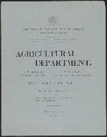
- Creator:
- Northern Transcontinental Survey. Agricultural Dept
- Published / Created:
- 1883
- Call Number:
- 847gc Y12 1883
- Container / Volume:
- BRBL_00628
- Image Count:
- 5
- Resource Type:
- Maps, Atlases & Globes
- Found in:
- Beinecke Rare Book and Manuscript Library > Map bulletin no. 1 / by E.W. Hilgard ; Northern Transcontinental Survey, Agricultural Department.
- Creator:
- Watson, Walter, civil engineer
- Published / Created:
- c1883.
- Call Number:
- 764 B45 1883
- Container / Volume:
- BRBL_00454
- Image Count:
- 1
- Resource Type:
- Maps, Atlases & Globes
- Found in:
- Beinecke Rare Book and Manuscript Library > Railway and highway map of the famous Berkshire Hills region, showing also villages and points of interest : from official records and other information / by Walter Watson, C.E. for the Berkshire Life Insurance Co. of Pittsfield, Mass., 1883.
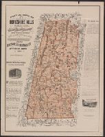
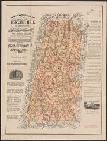
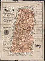
- Creator:
- Watson, Walter, civil engineer
- Published / Created:
- [1896].
- Call Number:
- 764 B45 1896
- Container / Volume:
- BRBL_00454
- Image Count:
- 1
- Resource Type:
- Maps, Atlases & Globes
- Found in:
- Beinecke Rare Book and Manuscript Library > Railway and highway map of the famous Berkshire Hills region, showing also villages and points of interest : from official records and other information / by Walter Watson, C.E. for the Berkshire Life Insurance Co. of Pittsfield, Mass., 1883 (Corrected 18
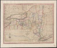
- Creator:
- Phelps, Humphrey
- Published / Created:
- 1832
- Call Number:
- 771 1833
- Container / Volume:
- BRBL_00478
- Image Count:
- 1
- Resource Type:
- Maps, Atlases & Globes
- Found in:
- Beinecke Rare Book and Manuscript Library > Map of the state of New York with the latest improvements / by H. Phelps.
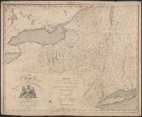
- Published / Created:
- [1804?]
- Call Number:
- 771 1804
- Container / Volume:
- BRBL_00477
- Image Count:
- 1
- Resource Type:
- Maps, Atlases & Globes
- Found in:
- Beinecke Rare Book and Manuscript Library > Map of the State of New York by Simeon DeWitt, Surveyor General ...
- Published / Created:
- 1858
- Call Number:
- 773 EL48 1858
- Container / Volume:
- BRBL_00496
- Image Count:
- 1
- Resource Type:
- Maps, Atlases & Globes
- Found in:
- Beinecke Rare Book and Manuscript Library > Map of the central and north part of Elizabeth, N.J.
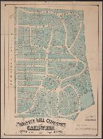
- Published / Created:
- 1870
- Call Number:
- 773 C127 1870
- Container / Volume:
- BRBL_00496
- Image Count:
- 1
- Resource Type:
- Maps, Atlases & Globes
- Found in:
- Beinecke Rare Book and Manuscript Library > Prospect Hill Cemetery, Caldwell, Essex Co., New Jersey / by Otis Chickering, Drainage, Landscape & Civil Engineer.
- Published / Created:
- 1865
- Call Number:
- 773 EL48 1865
- Container / Volume:
- BRBL_00496
- Image Count:
- 1
- Resource Type:
- Maps, Atlases & Globes
- Found in:
- Beinecke Rare Book and Manuscript Library > Map of the north part of Elizabeth, N.J.
- Published / Created:
- 1804
- Call Number:
- 773 J487 1804
- Container / Volume:
- BRBL_00496
- Image Count:
- 1
- Resource Type:
- Maps, Atlases & Globes
- Found in:
- Beinecke Rare Book and Manuscript Library > A map of that part of the town of Jersey, commonly called Powles Hook / surveyed by Joseph F. Mangin.
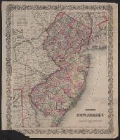
- Creator:
- G.W. & C.B. Colton & Co.
- Published / Created:
- 1866
- Call Number:
- 773 1866
- Container / Volume:
- BRBL_00495
- Image Count:
- 1
- Resource Type:
- Maps, Atlases & Globes
- Found in:
- Beinecke Rare Book and Manuscript Library > Colton's New Jersey [cartographic material].
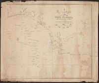
- Published / Created:
- 1823
- Call Number:
- 792cea 1823
- Container / Volume:
- BRBL_00519
- Image Count:
- 1
- Resource Type:
- Maps, Atlases & Globes
- Found in:
- Beinecke Rare Book and Manuscript Library > A particular Chart of the coasts of West Florida Louisiana Mississippi & Alabama ...
- Creator:
- Tanesse, I
- Published / Created:
- 1817
- Call Number:
- 795 N47 1817
- Container / Volume:
- BRBL_00522
- Image Count:
- 1
- Resource Type:
- Maps, Atlases & Globes
- Found in:
- Beinecke Rare Book and Manuscript Library > Plan of the city and suburbs of New Orleans : from an actual survey made in 1815 / by I. Tanesse ; Rollinson, sc.
- Published / Created:
- 1861
- Call Number:
- 792cea P38 1861
- Container / Volume:
- BRBL_00519
- Image Count:
- 1
- Resource Type:
- Maps, Atlases & Globes
- Found in:
- Beinecke Rare Book and Manuscript Library > The Key of the South, showing Fort Pickens and vicinity, positions of forts, batteries, fleet & soundings of every part of Pensacola Bay/ By M.K. Couzens, Litho. Lang & Laing.
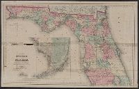
- Creator:
- G.W. & C.B. Colton & Co.
- Published / Created:
- c1876.
- Call Number:
- 792 1876C
- Container / Volume:
- BRBL_00518
- Image Count:
- 1
- Resource Type:
- Maps, Atlases & Globes
- Found in:
- Beinecke Rare Book and Manuscript Library > Colton's township map of the state of Florida.
- Published / Created:
- March 22, 1837.
- Call Number:
- 796 V541 1837
- Container / Volume:
- BRBL_00528
- Image Count:
- 1
- Resource Type:
- Maps, Atlases & Globes
- Found in:
- Beinecke Rare Book and Manuscript Library > The city of Velasco.
- Published / Created:
- 1860
- Call Number:
- 806gme 1860
- Container / Volume:
- BRBL_00549
- Image Count:
- 1
- Resource Type:
- Maps, Atlases & Globes
- Found in:
- Beinecke Rare Book and Manuscript Library > Map of the Warsaw and Rockford R.R. and its connections.
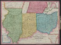
- Published / Created:
- 1843
- Call Number:
- 811 1843
- Container / Volume:
- BRBL_00552
- Image Count:
- 1
- Resource Type:
- Maps, Atlases & Globes
- Found in:
- Beinecke Rare Book and Manuscript Library > Traveller's map of Michigan, Indiana & Ohio.
- Published / Created:
- 1837
- Call Number:
- 811 1837
- Container / Volume:
- BRBL_00552
- Image Count:
- 1
- Resource Type:
- Maps, Atlases & Globes
- Found in:
- Beinecke Rare Book and Manuscript Library > The Surveyed Part of Michigan by John Farmer.
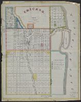
- Creator:
- G.W. & C.B. Colton & Co
- Published / Created:
- [1871]
- Call Number:
- 806 C43 1871
- Container / Volume:
- BRBL_00548
- Image Count:
- 1
- Resource Type:
- Maps, Atlases & Globes
- Found in:
- Beinecke Rare Book and Manuscript Library > The city of Chicago, Illinois.
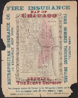
- Creator:
- G.W. & C.B. Colton & Co
- Published / Created:
- [1871]
- Call Number:
- 806 C43 1871A
- Container / Volume:
- BRBL_00548
- Image Count:
- 1
- Resource Type:
- Maps, Atlases & Globes
- Found in:
- Beinecke Rare Book and Manuscript Library > The city of Chicago, Illinois.
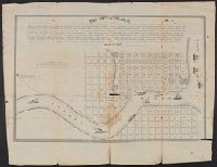
- Published / Created:
- 1834
- Call Number:
- 806gmb C43 1834
- Container / Volume:
- BRBL_00549
- Image Count:
- 1
- Resource Type:
- Maps, Atlases & Globes
- Found in:
- Beinecke Rare Book and Manuscript Library > Chicago. Drwn by J.S.Wright, according to survey.
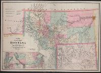
- Creator:
- De Lacy, W. W. (Walter Washington), 1819-1892
- Published / Created:
- 1871
- Call Number:
- 831 1871
- Container / Volume:
- BRBL_00579
- Image Count:
- 1
- Resource Type:
- Maps, Atlases & Globes
- Found in:
- Beinecke Rare Book and Manuscript Library > Map of the territory of Montana with portions of the adjoining territories / compiled and drawn by W.W. De Lacy of the Surveyor General's Office.
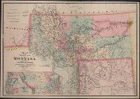
- Creator:
- De Lacy, W. W. (Walter Washington), 1819-1892
- Published / Created:
- 1878
- Call Number:
- 831 1878
- Container / Volume:
- BRBL_00579
- Image Count:
- 1
- Resource Type:
- Maps, Atlases & Globes
- Found in:
- Beinecke Rare Book and Manuscript Library > Map of the territory of Montana with portions of the adjoining territories / compiled and drawn by W.W. De Lacy, civil engineer & surveyor, Helena, M.T.
- Creator:
- American Geographical Society of New York
- Published / Created:
- 1929
- Call Number:
- 923 1929
- Container / Volume:
- BRBL_00673
- Image Count:
- 1
- Resource Type:
- Maps, Atlases & Globes
- Found in:
- Beinecke Rare Book and Manuscript Library > Map of the Chaco Boreal [cartographic material] / compiled by the American Geographical Society of New York.
- Published / Created:
- [1913?]
- Call Number:
- 94gme 1913
- Container / Volume:
- BRBL_00675
- Image Count:
- 1
- Resource Type:
- Maps, Atlases & Globes
- Found in:
- Beinecke Rare Book and Manuscript Library > Railway map of Argentine Republic.
- Published / Created:
- 1835
- Call Number:
- 97 L62 1685
- Container / Volume:
- BRBL_00678
- Image Count:
- 1
- Resource Type:
- Maps, Atlases & Globes
- Found in:
- Beinecke Rare Book and Manuscript Library > View of Lima. "The City of Kings." before its destruction by the great earthquake of 1746.
- Creator:
- Nell, Louis
- Published / Created:
- 1868
- Call Number:
- 844gme 1868
- Container / Volume:
- BRBL_00619
- Image Count:
- 1
- Resource Type:
- Maps, Atlases & Globes
- Found in:
- Beinecke Rare Book and Manuscript Library > Topographical railroad & county map of the states of California and Nevada : compiled from the latest explorations and other official information / by L. Nell.
- Published / Created:
- [ca. 1867]
- Call Number:
- 771 R98 1867
- Container / Volume:
- BRBL_00490
- Image Count:
- 1
- Resource Type:
- Maps, Atlases & Globes
- Found in:
- Beinecke Rare Book and Manuscript Library > Glendale [Rye] Westchester Co., N.Y. / Laid off by Andrew Wilson, Jr. surveyed and platted by A. Steinacter. etc.
- Creator:
- Shepard, Augustus D
- Published / Created:
- 1906
- Call Number:
- 771 Ad47 1906
- Container / Volume:
- BRBL_00480
- Image Count:
- 1
- Resource Type:
- Maps, Atlases & Globes
- Found in:
- Beinecke Rare Book and Manuscript Library > Adirondack League Club preserve / copied and developed by Augustus D. Shepard ... from the topographic sheets of the U.S. Geological Survey.
- Published / Created:
- c1901.
- Call Number:
- 75 1901
- Container / Volume:
- BRBL_00407
- Image Count:
- 1
- Resource Type:
- Maps, Atlases & Globes
- Found in:
- Beinecke Rare Book and Manuscript Library > The United States / by Rand, McNally & Co.
- Published / Created:
- 1890
- Call Number:
- 7645am C82 1890
- Container / Volume:
- BRBL_00463
- Image Count:
- 1
- Resource Type:
- Maps, Atlases & Globes
- Found in:
- Beinecke Rare Book and Manuscript Library > Cottage City, Martha's Vineyard, Mass. 1890.
- Published / Created:
- 1848
- Call Number:
- 75EG 1848L
- Container / Volume:
- BRBL_00410
- Image Count:
- 1
- Resource Type:
- Maps, Atlases & Globes
- Found in:
- Beinecke Rare Book and Manuscript Library > Lewis' free soil, slavery, and territorial map of the United States.
- Creator:
- Tanner, Henry Schenck, 1786-1858
- Published / Created:
- 1840
- Call Number:
- 75gm 1840C
- Container / Volume:
- BRBL_00410
- Image Count:
- 1
- Resource Type:
- Maps, Atlases & Globes
- Found in:
- Beinecke Rare Book and Manuscript Library > Map of the canals & rail roads of the United States / reduced from the large map of the U.S. by H.S. Tanner ; engraved by J. Knight.
- Creator:
- Tanner, Henry Schenck, 1786-1858
- Published / Created:
- 1840
- Call Number:
- 75gm 1840B
- Container / Volume:
- BRBL_00410
- Image Count:
- 1
- Resource Type:
- Maps, Atlases & Globes
- Found in:
- Beinecke Rare Book and Manuscript Library > Map of the canals & rail roads of the United States / reduced from the large map of the U.S. by H.S. Tanner ; engraved by J. Knight.
- Creator:
- Burr, Henry A
- Published / Created:
- 1853
- Call Number:
- 75GM 1853
- Container / Volume:
- BRBL_00410
- Image Count:
- 1
- Resource Type:
- Maps, Atlases & Globes
- Found in:
- Beinecke Rare Book and Manuscript Library > Disturnell's new map of the United States and Canada : showing all the canals, rail roads, telegraph lines and principal stage routes / Drawn by Henry A. Burr.
- Creator:
- G.W. & C.B. Colton & Co
- Published / Created:
- 1869
- Call Number:
- 754gme 1869
- Container / Volume:
- BRBL_00420
- Image Count:
- 1
- Resource Type:
- Maps, Atlases & Globes
- Found in:
- Beinecke Rare Book and Manuscript Library > Map showing the route of the Brunswick and Albany Railroad Company of Georgia : and its connections / prepared by G.W. & C.B. Colton & Co. 172 Williams St. New York.
- Published / Created:
- 1850
- Call Number:
- 754gme 1850
- Container / Volume:
- BRBL_00419
- Image Count:
- 1
- Resource Type:
- Maps, Atlases & Globes
- Found in:
- Beinecke Rare Book and Manuscript Library > [Railroads of the Lake States, from Great Lakes to Ohio River]
- Published / Created:
- 1853
- Call Number:
- 754gme 1853
- Container / Volume:
- BRBL_00419
- Image Count:
- 1
- Resource Type:
- Maps, Atlases & Globes
- Found in:
- Beinecke Rare Book and Manuscript Library > Map of the Delaware, Lackawanna & Western railroad : with its principal connections.
- Published / Created:
- 1851
- Call Number:
- 754gme 1851
- Container / Volume:
- BRBL_00419
- Image Count:
- 1
- Resource Type:
- Maps, Atlases & Globes
- Found in:
- Beinecke Rare Book and Manuscript Library > Map of the Hudson and Delaware Rail Road : connecting the Newburgh Branch R.R. at Chester with the Ligetts Gap R.R. at the Water Gap, and showing the continuous rail-way communication which will thus be formed between the coal beds of Pena. and Boston. 18
- Creator:
- J.H. Colton & Co.
- Published / Created:
- 1858
- Call Number:
- 754gme 1858
- Container / Volume:
- BRBL_00420
- Image Count:
- 1
- Resource Type:
- Maps, Atlases & Globes
- Found in:
- Beinecke Rare Book and Manuscript Library > Map of the Mississippi and Missouri Railroad : and its connections.
- Published / Created:
- [1857?]
- Call Number:
- 754gme 1857
- Container / Volume:
- BRBL_00419
- Image Count:
- 1
- Resource Type:
- Maps, Atlases & Globes
- Found in:
- Beinecke Rare Book and Manuscript Library > Map showing position of the Lake Erie and Pacific rail road : and its connections / [by] Chas. E. Hore, mechanical and topographical draftsman, 308 Broadway, N.Y.
- Creator:
- Colton, G. Woolworth (George Woolworth), 1827-1901
- Published / Created:
- 1862
- Call Number:
- 754gme 1860A
- Container / Volume:
- BRBL_00420
- Image Count:
- 1
- Resource Type:
- Maps, Atlases & Globes
- Found in:
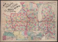
- Beinecke Rare Book and Manuscript Library > Colton's county and township rail road map of Wisconsin, Illinois, Missouri, & Iowa / Drawn, engraved & published by G. Woolworth Colton
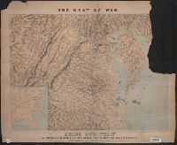
- Creator:
- Schedler, Joseph
- Published / Created:
- c1861.
- Call Number:
- 754hc 1862B
- Container / Volume:
- BRBL_00421
- Image Count:
- 1
- Resource Type:
- Maps, Atlases & Globes
- Found in:
- Beinecke Rare Book and Manuscript Library > The seat of war : birds eye view of Virginia, Maryland, Delaware and the District of Columbia / drawn and engr. by J. Schedler.
- Creator:
- H. H. Lloyd & Co. (New York, N.Y)
- Published / Created:
- 188-.
- Call Number:
- 754gme 1881
- Container / Volume:
- BRBL_00420
- Image Count:
- 1
- Resource Type:
- Maps, Atlases & Globes
- Found in:
- Beinecke Rare Book and Manuscript Library > Map showing the connections of the Illinois Central Railroad : with the railway lines to the Gulf ports.
- Creator:
- Steinwehr, A. von (Adolph), 1822-1877
- Published / Created:
- [1855]
- Call Number:
- 754EG 1855
- Container / Volume:
- BRBL_00418
- Image Count:
- 1
- Resource Type:
- Maps, Atlases & Globes
- Found in:
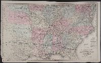
- Beinecke Rare Book and Manuscript Library > Map showing the distribution of slaves in the Southern States / projected & compiled by A. von Steinwehr.
- Published / Created:
- 186-.
- Call Number:
- 754gme 1865
- Container / Volume:
- BRBL_00420
- Image Count:
- 1
- Resource Type:
- Maps, Atlases & Globes
- Found in:
- Beinecke Rare Book and Manuscript Library > Map of the Williamsport and Elmira rail road : with its connections.
- Published / Created:
- 1848
- Call Number:
- 76 1848
- Container / Volume:
- BRBL_00445
- Image Count:
- 1
- Resource Type:
- Maps, Atlases & Globes
- Found in:
- Beinecke Rare Book and Manuscript Library > Map of Massachusetts, Rhode Island and Connecticut.