Anville, Jean Baptiste Bourguignon d', 1697-1782 Gravelot, Sr Major, Sr
Published / Created:
1746
Call Number:
2003 Folio 85
Image Count:
1
Description:
Inset map: [Hudson Bay-Labrador Region]. and No. 2 of 45 maps bound together with binder’s spine title: Atlas of America; ms. table of contents. Bookplate of Paul Mellon.
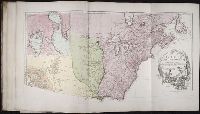
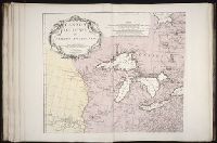
Anville, Jean Baptiste Bourguignon d', 1697-1782 Haye, G. de la
Published / Created:
avec privilege 1748
Call Number:
2003 Folio 85
Image Count:
1
Description:
Hand colored., 2003 Folio 85: No. 43 of 45 maps bound together with binder’s spine title: Atlas of America, Bookplate: Robinson. Bookplate of Paul Mellon, Relief shown pictorially., and Scale [ca. 1:2,500,000]
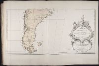
BEIN 2003 Folio 85: No. 42 of 45 maps bound together with binder's spine title: Atlas of America; ms. table of contents. Bookplate: Robinson. Bookplate of Paul Mellon., Hand colored., par le Sr. Robert de Vaugondy, fils de Mr. Robert, geographe ordinaire du roy., Relief shown pictorially., and Scale [ca. 1:17,000,000]
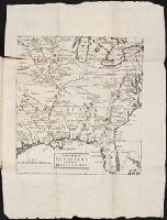
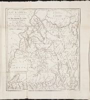
Anville, Jean Baptiste Bourguignon d', 1697-1782 Haye, G. de la
Published / Created:
Novembre 1755
Call Number:
2003 Folio 85
Image Count:
1
Description:
BEIN 2003 Folio 85: No. 3 of 45 maps bound together with binder's spine title: Atlas of America; ms. table of contents. Bookplate: Robinson. Bookplate of Paul Mellon., From the author's Atlas general. 1743-80., Hand colored., Has watermarks., National Maritime Museum. Catalog,, par le Sr. d'Anville ... ; [Gravee par] G. De-La-Haye., Relief shown pictorially., Scale [ca. 1:2,750,000]., and Sous le privilege de l'Academie.
Publisher:
Chez l'auteur, aux galeries du Louvre
Subject (Geographic):
Canada -- Maps -- Early works to 1800, Louisiana -- Maps -- Early works to 1800, and North America -- Maps -- Early works to 1800
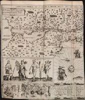
Les voyages dv sievr de Champlain Xaintongeois, capitaine ordinaire pour le Roy, en la marine
Image Count:
1
Abstract:
Inset images of Montaignais & Almouchicois Indians.
Description:
Tipped in following p. 52.
Subject (Geographic):
New France --Discovery and exploration and New France --Maps --Early works to 1800
Subject (Name):
Pelletier, David
Subject (Topic):
Indians of North America --Canada and Indians of North America --Clothing
Collection Created:
A Paris : Chez Iean Berjon, rue S. Iean de Beauuais, au Cheual volant, & en sa boutique au Palais, a la gallerie des prisonniers, MDCXIII [1613]. Avec privilege dv Roy
"Avec une Description Géographique de cette Partie de l'Amerique.", BEIN BrSides Zc10 755be: Not colored. With "Prix cinquante Sols" in lower right corner., In upper left cartouche "Remarques Les Possessions des Francois, sont colorées en Bleu, Celles des Anglois en Jaune, Et celles des Espagnols en Rouge.", Includes three bar scales., Prime meridian: Paris., Relief shown pictorially., and Watermark.
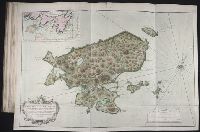
Bellin, Jacques Nicolas, 1703-1772, creator France, Depot des cartes et plans de la marine
Published / Created:
1763
Call Number:
2003 Folio 85
Image Count:
1
Alternative Title:
Carte d'une partie de l'isle de Terre Neuve et les isles de St. Pierre et Miquelon [scale ca. 1:666,666]
Description:
BEIN 2003 Folio 85: No. 12 of 45 maps bound together with binder's spine title: Atlas of America; ms. table of contents. Bookplate: Robinson. Bookplate of Paul Mellon., Hand colored., par le S. Bellin ingenieur de la marine et du Depost M.DCC.LXIII., and Scale [ca. 1:15,400].
Publisher:
DeÌpost des cartes et plans de la marine
Subject (Geographic):
Newfoundland and Labrador -- Maps -- Early works to 1800 and Saint Pierre and Miquelon -- Maps -- Early works to 1800