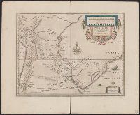
Paragvay, ó, prov. de Rio de la Plata cum regionibus adiacentibus Tvcvman et Sta. Crvz de la Sierra
Description:
Bar scales in "Milliaria Germanica communia" and "Milliaria Gallica communia.", From From Jansson's Nieuwen atlas ... Amstelodami : Apud Ioannem Ianssonium, 1647., In Dutch on verso, with caption title "De Provincien van Rio de la Plata ofte Paraguay, Tucuman, ende Sta. Cruz de la Sierra" and signature 2P., and Relief shown pictorially.
Publisher:
Excudebat Ioannes Ianssonius,
Subject (Geographic):
Argentina--Maps--Early works to 1800, Paraguay--Maps--Early works to 1800, and Uruguay--Maps--Early works to 1800
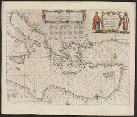
Bar scales in "Miliaria Germanica communia" and "Miliaria Gallica communia.", Cross Collection no. 356., From Jan Jansson and Henrik Hondius's Atlas novus ... Amstelodami : Apud Ionnem Ianssonium & Henricum Hondium, 1638., In Latin on verso, with caption titles "Peruvia" and "Peruviae descriptio" and signature 5C., Oriented with north to the left., and Relief shown pictorially.
Publisher:
Apud Ioannem Ianssonium,
Subject (Geographic):
Peru--Maps--Early works to 1800
Subject (Name):
Hondius, Hendrik, 1597-1651. Atlas novus and Jansson, Jan, 1588-1664. Atlas novus
Bar scales in "Miliaria Germanica communia" and "Miliaria Gallica communia.", From Jansson's Nieuwen atlas ... Amstelodami : Apud Ionnem Ianssonium, 1647., Imperfect: torn along fold, with no loss of text. Sheet measures 50 x 61 cm., In Dutch on verso, with caption titles "Peru" and signature 2L., Oriented with north to the left., and Relief shown pictorially.
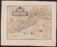
"Abraham Goos sculpsit.", From Atlantis majoris appendix, sive pars altera. Amstelodami : Joannis Janzonii, 1630., Inset of "Territorij Syracusani loca, incertae positionis, Acrillae, Echetla, Magella.", Relief shown pictorically., and Sheet measures 50 x 62 cm.
Publisher:
Apud Joannem Janssonium,
Subject (Geographic):
Sicily--Maps--Early works to 1800
Subject (Name):
Goos, Abraham and Jansson, Jan, 1588-1664. Atlantis majoris appendix, sive pars altera
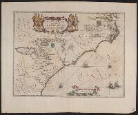
Bar scales in "Milliaria Germanica communia" and "Milliaria Gallica communia.", From Jansson's Nieuwen atlas ... Amsterodami : Apud Ioannem Ianssonium, 1647., Relief shown pictorially., Sheet measures 50 x 60.5 cm., and Text in Dutch on verso, with caption title "Venezuela ende nieu Andaluzie" and signature 2M.
Appeared in various editions of Jan Jansson's Accuratissima orbis antiqui delineatio., Manuscript number in upper left corner: 20., Relief shown pictorially., and Verso blank.
Publisher:
[Jan Jansson],
Subject (Geographic):
Balkan Peninsula--Maps--Early works to 1800. and Pannonia--Maps--Early works to 1800.
Subject (Name):
Jansson, Jan, 1588-1664. Accuratissima orbis antiqui delineatio.
Appears in various, Hand col. Sheet measures 50 x 60.9 cm., Latin text on recto; Dutch text on verso., Prime meridian Ferro., Relief shown pictorially., and Verso in Dutch, with running and caption title "Florida," signature 2E and catchword "rivieren".
Cross Collection no. 60., From Janssonius's Niewen atlas ... Amstelodami : Apud Ioannem Ianssonium, 1652., Hand col. Mounted on linen., Includes marginal ill., Relief shown pictorially., Title supplied by cataloger., and Variant of Hondius' Polus Antarcticus, 1638.
Publisher:
J. Jansson,
Subject (Geographic):
Antarctica--Maps--Early works to 1800 and Southern Hemisphere--Maps--Early works to 1800