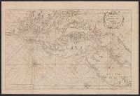
English pilot. Book 4. and Virginia, Maryland, Pennsylvania, east & west New Jersey
Description:
Appears in various eds. of The English pilot, Book 4., Depths shown by soundings., Mounted on linen. Sheet measures 59.1 x 87.2 cm. Cross Collection no. 191., Nautical chart of the coast from New York Bay to Chesapeake Bay,, and Oriented with north to the right.
Publisher:
Sold by William Mount & Tho. Page, Tower Hill,
Subject (Geographic):
Middle Atlantic States--Maps--Early works to 1800
Subject (Name):
Mount, William, d. 1769, bookseller and Page, Thomas, d. 1733, bookseller
Subject (Topic):
Coasts--Middle Atlantic States--Maps--Early works to 1800, Nautical charts--Atlantic Coast (Middle Atlantic States)--Early works to 1800, and Nautical charts--Middle Atlantic States--Early works to 1800