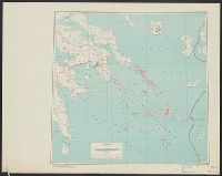
Its A.M.S. 9101 and Series (Standard map series designation system) ; 9101.
Description:
"Mercator projection.", Elevations are shown by hachures and spot heights in meters., Inset: Sangihe-Talaud eilanden., and Principal roads and trails are shown.
Its A.M.S. ; M961 and Series (Standard map series designation system) ; M961.
Description:
"Copied from a French map 1:6,000, Nouveau plan de Charleville-Mezieres.", At head of title: France 1:5,000., and Some streets and buildings are named.
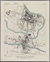
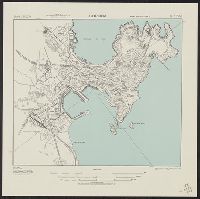
Fu-chou (Foochow) and Nan-t'ai, China, Fukien Province, Fu-chou and Nan-ta̓i, and L901
Description:
"Compiled in 1945 from China 1:50,000 Army Map Service 8833 II (Type C) 1945. Planimetric detail intensifie, Marginal maps: Coverage diagram -- Index to boundaries., Military grid., and Some streets and buildings are named; wooded and cultivated areas are shown.
Publisher:
U.S. Army Map Service,
Subject (Geographic):
Fuzhou (Fujian Sheng, China)--Maps and Nan-t'ai Shi (Fujian Sheng, China)--Maps
"3-43.", "Copied from French map, 1:50,000, Colmar F 37-18, revised to 1926.", "First edition 1943.", A few buildings are named., Military grid., Place names and buildings in French., and Relief show by spot heights.
"Copied from I. S. I. S. report, 1:2,400, La Coruna, CB 1811, no. 12, 1942.", At head of title: Spain 1:10,000., and Some streets and buildings are named.
Its A.M.S. ; 6201 and Series (Standard map series designation system) ; 6201.
Description:
"Conical orthomorphic projection (Lambert conformal conic projection).", Elevations are shown by hachures and spot heights in meters., Inset shows area with detailed transportation information., and Principal roads, trails and railroads are shown.