"To the Rt. Honble Anthony Earle of Shaftesbury Baron Ashley of Wimbourne St. Giles and Lord Cooper of Pawlet....", Has watermark., Includes decorative cartouche and ill., and Relief shown pictorially.
New map of the kingdom of England and Dominion of Wales, New map of the kingdome of England and Wales, and New mapp of the kingdom of England and Dominion of Wales
Description:
Imperfect: upper right of map mutilated, with some loss of text., No. 4 of 69 maps bound together in composite atlas., Relief shown pictorially., Scale [ca. 1:1 110 000]., With an alphabeticall table of all the cities and market towns in England and Wales., and With dedication To the most serene and most sacred Majesty William III ... from William Berry.
Publisher:
Sold by William Berry at the sign of the Globe between Charing Cross and White Hall
Subject (Geographic):
Great Britain --Maps --Early works to 1800
Subject (Topic):
Roads --Great Britain --Maps --Early works to 1800
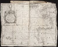
Copper engraved sea chart, colored by hand to show coasts of English counties and French providinces, Flanders, Holland, etc ... Loxodromes, direction of compass, shoals, soundings, coastal towns., Decorative title, dedicatory, and scal, and Preliminary record.
Certaine errors in nauigation / detected and corrected by Edw. Wright ; with many additions that
Image Count:
1
Description:
[ca. 1:5,400,000]., Bound in following p. 110., Linear brown stain at top on verso., Middle panel right of center has small hole., and Several small yellow, brown and black stains can be seen on both the recto and verso.
Subject (Geographic):
Azores
Subject (Topic):
Cosmography--Early works to 1800, Nautical astronomy --Early works to 1800, and Navigation --Early works to 1800
Collection Created:
[London] : Printed by Felix Kingsto[n] at London, 1610
A topographical description of the Western territory of North America; containing a succinct
Image Count:
1
Description:
Engrav'd for S. Campbell's Edition of Imlay's Description of Kentucky., Facing p. 111., and Teaching resource: Professor John Mack Faragher, History 141: The American West.
Subject (Geographic):
Genesee River Valley (Pa. and N.Y.) --Early works to 1800, Mississippi River Valley --Description and travel --Early works to 1800, Mississippi River Valley --History --To 1803, and Ohio River Valley --Description and travel -
Subject (Name):
Filson, John, ca. 1747-1788 Discovery, settlement, and present state of Kentucky, Toulmin, Harry, 1766-1823 Thoughts on emigration, and United States. Dept. of State
Subject (Topic):
Public lands --United States --Early works to 1800
Collection Created:
New-York, Printed by Samuel Campbell, No. 37, Hanover Square, M,DCC,XCIII