Pictorial border consisting of 5 inset maps: Melish's map, 1816, Penn's lots, 1698, Penn's plan, 1682, New Sweden, 1654, and the Sesqvi Centennial international exposition; the seals of Penn's colony and of the city of Philadelphia, 1701 and 1784; and 38 historical scenes.
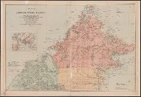
Covers Brunei, Sabah, and northern Sarawak., Includes inset location map., Land available for sale or sold indicated., Library copy accompanied by manuscript notes., and Relief shown by hachures and spot heights. Soundings in fathoms.
Publisher:
Published by Edward Stanford for the British North Borneo Company,
National Geographic Society (U.S.). Cartographic Section
Published / Created:
1954
Call Number:
844 1954
Container / Volume:
BRBL_00603
Image Count:
1
Resource Type:
Maps, Atlases & Globes
Description:
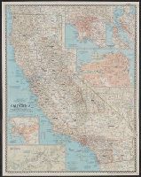
"Compiled by R.J. Darley, R.G. Fritz, A.D. Grazzini, R.E. McAleer, R.W. Northrop, W.T. Peele, F.W. Sheppard, and C.L. Stern. Physiography by J.J. Brehm and A.E. Holdstock. Typography by C.E. Riddiford." and Ancillary maps: Los Angeles [Scale 1:380,160] -- San Francisco Bay region [Scale 1:380,160] -- San Francisco [Scale ca. 1:41,000] -- San Diego [Scale 1:190,080] -- Yosemite Valley, Yosemite National Park [Scale 1:63,360].
Publisher:
National Geographic Society,
Subject (Geographic):
California--Maps
Subject (Name):
Brehm, J. J, Darley, Richard J, Fritz, R. G, Grazzini, Athos D, Holdstock, A. E, McAleer, Ralph E, Northrop, R. W, Peele, William T, Riddiford, Charles E, and S
National Geographic Society (U.S.). Cartographic Section
Published / Created:
1954
Call Number:
844 1954
Container / Volume:
BRBL_00603
Image Count:
1
Resource Type:
Maps, Atlases & Globes
Description:
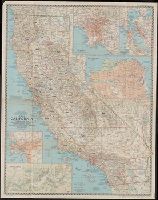
"Compiled by R.J. Darley, R.G. Fritz, A.D. Grazzini, R.E. McAleer, R.W. Northrop, W.T. Peele, F.W. Sheppard, and C.L. Stern. Physiography by J.J. Brehm and A.E. Holdstock. Typography by C.E. Riddiford." and Ancillary maps: Los Angeles [Scale 1:380,160] -- San Francisco Bay region [Scale 1:380,160] -- San Francisco [Scale ca. 1:41,000] -- San Diego [Scale 1:190,080] -- Yosemite Valley, Yosemite National Park [Scale 1:63,360].
Publisher:
National Geographic Society,
Subject (Geographic):
California--Maps
Subject (Name):
Brehm, J. J, Darley, Richard J, Fritz, R. G, Grazzini, Athos D, Holdstock, A. E, McAleer, Ralph E, Northrop, R. W, Peele, William T, Riddiford, Charles E, and S
Map of China showing the stations of the China Inland Mission
Description:
"China Inland Mission stations with resident missionary are underlined in red.", "Stanford's Geog! Estab., London.", and Covers on verso not digitized.
"Caution" text gives meaning of buoy colors and general rules for small craft navigation., "This map (outline) is copied from an old tracing in the possession of Mr. Wm. Puffer of Boston, Mass. It has been carefully tested by taking many cross sights ...", Bathymetry shown by spot heights., Includes area and distance statistics of lake and islands., Insets: Little Bear Isl'd thorofare -- Entrance to Lees Mills thorofare -- Entrance to Green's Basin -- Three Mile Island thorofare., Oriented with north toward the upper left., and Shows buoys, fixed lights, steamer routes, railroads and stations, post offices, sunken rocks and shoals.
Publisher:
E.N. Burwell,
Subject (Geographic):
Winnipesaukee, Lake (N.H.)--Maps and Winnipesaukee, Lake (N.H.)--Navigation--Maps
National Geographic Society (U.S.). Cartographic Section
Published / Created:
1941
Call Number:
80 1941
Container / Volume:
BRBL_00536
Image Count:
1
Resource Type:
Maps, Atlases & Globes
Description:
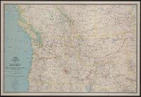
"Culture by Apphia E. Holdstock. Research by Wellman Chamberlin. Physiography by John J. Brehm.", Issued with the National geographic magazine, v. 79, no. 6, June 1941., Relief shown by hachures and spot heights., and Shows routes of exploration and includes notes on historical sites and points of interest.
Publisher:
The Society,
Subject (Geographic):
Alberta--Maps, British Columbia--Maps, Northwest, Pacific--Maps, and Saskatchewan--Maps
Subject (Name):
Brehm, J. J, Chamberlin, Wellman, Darley, James M. (James Morrison), and Holdstock, A. E
"A note of explanation" on verso., "December 1956, Westways, vol. 48, no. 12.", Includes text, ills., and index (with descriptions of sites)., Insets: San Francisco-Monterey area -- Los Angeles & vicinity area., and Oriented with north towards upper right.
Publisher:
Westways,
Subject (Geographic):
California--Historical geography--Maps and California--Imprints
Subject (Name):
Automobile Club of Southern California, Butler, Lowell (Bernard Lowell), Hanna, Phil Townsend, 1896-1957, and Newbro, William H