Skip to search
Skip to main content
Skip to first result
Search
You Searched For
Language
Latin
Language
French
New Search
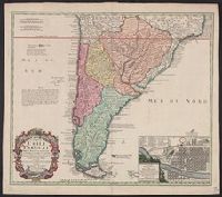
Search Results
Published / Created:
ca. 163--1734]
Call Number:
1973 Folio 18
Image Count:
10
Resource Type:
Maps, Atlases & Globes
Found in:
Beinecke Rare Book and Manuscript Library > [Composite atlas of the world].
Creator:
Published / Created:
[ca. 1508?]
Call Number:
Hfa22 239
Image Count:
49
Resource Type:
Books, Journals & Pamphlets
Found in:
Beinecke Rare Book and Manuscript Library > Ouide De arte amendi[!] / translate de latin en francoys.
Published / Created:
[ca. 1775]
Call Number:
Mellon MS 121
Image Count:
75
Resource Type:
Archives or Manuscripts
Found in:
Beinecke Rare Book and Manuscript Library > Thesaurus thesaurorum.
Creator:
Published / Created:
A. MDCCXXXIII [1733]
Call Number:
935 1733A
Container / Volume:
BRBL_00674
Image Count:
1
Resource Type:
Maps, Atlases & Globes
Found in:
Beinecke Rare Book and Manuscript Library > Typus geographicus : Chili a Paraguay freti Magellanici &c., ex. PPbg. Alfonso d'Ovalle & Nicol. Techo nec non de Brouwer, Narbouroug, de Beauchesne &c., a Guiliel de l'Islio descripta, insuperque secundum recentiores du Frezier relationes rectificata cui
Creator:
Published / Created:
1774
Call Number:
70 1774A
Container / Volume:
BRBL_00724
Image Count:
1
Resource Type:
Maps, Atlases & Globes
Found in:
Beinecke Rare Book and Manuscript Library > Carte d'Amerique : divisées en ses principales parties / par G. Delisle, premier geographe du Roy, rectifiée apres les nouvelles observations du Sr. D'Anville et autres geographes ; J. Condet, sc.
Creator:
Published / Created:
[approximately 1700?]
Call Number:
BrSides Double Folio 2019 71
Image Count:
1
Resource Type:
Maps, Atlases & Globes
Found in:
Beinecke Rare Book and Manuscript Library > Peloponnesus sive Morea / auth. J. Laurenbergio.
Creator:
Published / Created:
1667?]
Call Number:
85 1667
Container / Volume:
BRBL_00636
Image Count:
1
Resource Type:
Maps, Atlases & Globes
Found in:
Beinecke Rare Book and Manuscript Library > Insulae Americanae in Oceano Septentrionali cum terris adiacentibus.
Creator:
Published / Created:
1667?]
Call Number:
85 1667
Container / Volume:
BRBL_00636
Image Count:
1
Resource Type:
Maps, Atlases & Globes
Found in:
Beinecke Rare Book and Manuscript Library > Insulae Americanae in Oceano Septentrionali cum terris adiacentibus.
Creator:
Published / Created:
1746
Call Number:
11 1746A
Container / Volume:
BRBL_00681
Image Count:
1
Resource Type:
Maps, Atlases & Globes
Found in:
Beinecke Rare Book and Manuscript Library > Planiglobii terrestris mappa universalis utrumq[ue] hemisphaerium orient. et occidentale repraesentans, ex IV. mappis generalibus, Hasianis composita et adjectis ceteris hemisphaeriis / designata a G.M. Lowizio ; excudentibus Homann. Heredibus = Mappe-mon
Creator:
Call Number:
11 1746A
Image Count:
1
Resource Type:
Maps, Atlases & Globes
Found in:
Beinecke Rare Book and Manuscript Library > Planiglobii terrestris mappa universalis utrumq[ue] hemisphaerium orient. et occidentale repraesentans, ex IV. mappis generalibus, Hasianis composita et adjectis ceteris hemisphaeriis / designata a G.M. Lowizio ; excudentibus Homann. Heredibus = Mappe-monde qui représente les deux hemisphères savoir celui de l'orient et celui de l'occident, tirée des quatre cartes générales de feu M. le profess. Hasius / dressée par M. G.M. Lowitz, et publiée par les Héritiers de Homann.
Creator:
Published / Created:
[after 1772]
Call Number:
BrSides Double Folio 2019 28
Image Count:
1
Resource Type:
Maps, Atlases & Globes
Found in:
Beinecke Rare Book and Manuscript Library > Mappa geographica Regni Poloniae : ex novissimis quotquot sunt mappis specialibus composita et ad L.L. stereographica projectionis / revocata à Tob. Mayero.
Creator:
Call Number:
BrSides Double Folio 2019 29
Image Count:
1
Resource Type:
Maps, Atlases & Globes
Found in:
Beinecke Rare Book and Manuscript Library > Belgivm Catholicvm seu decem provinciae Germaniae inferioris : cum confiniis Germaniae svp. et Franciae legitime omnia delineata et ad ductum observationum astronomicarum, nec non geometricarum operationum a Cassinio Snellio Muschenbrokio aliisqve rite ha
Creator:
Published / Created:
ca. 1730]
Call Number:
783 1759
Container / Volume:
BRBL_00691
Image Count:
1
Resource Type:
Maps, Atlases & Globes
Found in:
Beinecke Rare Book and Manuscript Library > Virginia, Marylandia et Carolina in America septentrionali Brittannorum industria excultæ / repraesentatae à Ioh. Bapt. Homann, S.C.M. Geog.
Creator:
Published / Created:
1630]
Call Number:
783 1622
Container / Volume:
BRBL_00691
Image Count:
1
Resource Type:
Maps, Atlases & Globes
Found in:
Beinecke Rare Book and Manuscript Library > Nova Virginiae tabvla / [cartographic material] / Petrus Koerius caelavit.
Creator:
Published / Created:
ca. 1730-ca. 1800]
Call Number:
1973 Folio 71
Image Count:
1
Resource Type:
Maps, Atlases & Globes
Found in:
Beinecke Rare Book and Manuscript Library > [Atlas nouveau contenant toutes les parties du monde ou sont exactement marqués les empires, monarchies, royaumes, états, republiques &c. Le tout recueilli par les meilleurs geógraphes.]
Creator:
Published / Created:
ca. 1714]
Call Number:
755 1759
Container / Volume:
BRBL_00728
Image Count:
1
Resource Type:
Maps, Atlases & Globes
Found in:
Beinecke Rare Book and Manuscript Library > Virginia, Marylandia et Carolina in America septentrionali Brittannorum industria excultae / repraesentatae à Ioh. Bapt. Homann, S.C.M. Geog.
Creator:
Published / Created:
ca. 1714]
Call Number:
755 1714
Container / Volume:
BRBL_00425
Image Count:
1
Resource Type:
Maps, Atlases & Globes
Found in:
Beinecke Rare Book and Manuscript Library > Virginia, Marylandia et Carolina in America septentrionali Brittannorum industria excultae / repraesentatae à Ioh. Bapt. Homann, S.C.M. Geog.
Creator:
Published / Created:
1749
Call Number:
BrSides Double Folio 2017 5
Image Count:
1
Resource Type:
Maps, Atlases & Globes
Found in:
Beinecke Rare Book and Manuscript Library > Tatariae sinensis mappa geographica [cartographic material] / ex tabuli specialibus R.R.P.P. Iesuitarum nec non relationibus R.P. Gerbillon per Dom D'Anville geographum parisiensem primum Ao. 1732 nunc secundam LL. projectionis stereographicae in usum tra
Creator:
Published / Created:
[1609]
Call Number:
60 1609
Container / Volume:
BRBL_00321
Image Count:
2
Resource Type:
Maps, Atlases & Globes
Found in:
Beinecke Rare Book and Manuscript Library > Nova Africae tabula / auctore Jodoco Hondio.
Creator:
Published / Created:
between 1639 and 1649?]
Call Number:
60 1639
Container / Volume:
BRBL_00321
Image Count:
2
Resource Type:
Maps, Atlases & Globes
Found in:
Beinecke Rare Book and Manuscript Library > Africae nova tabula / auct. Hen. Hondio, 1631.
Creator:
Published / Created:
between 1639 and 1644?]
Call Number:
70 163X
Container / Volume:
BRBL_00353
Image Count:
2
Resource Type:
Maps, Atlases & Globes
Found in:
Beinecke Rare Book and Manuscript Library > America noviter delineata / auct. Henrico Hondio, 1631.
Creator:
Published / Created:
between 1643 and 1650]
Call Number:
64 1643
Container / Volume:
BRBL_00338
Image Count:
2
Resource Type:
Maps, Atlases & Globes
Found in:
Beinecke Rare Book and Manuscript Library > Aethiopia inferior vel exterior.
Creator:
Published / Created:
[between 1635 and 1650]
Call Number:
11 1635
Container / Volume:
BRBL_00003
Image Count:
2
Resource Type:
Maps, Atlases & Globes
Found in:
Beinecke Rare Book and Manuscript Library > Nova totius terrarum orbis geographica ac hydrographica tabula / auct. Guiljelmo Blaeuw ; Ja. van den Ende sculpsit.
Creator:
Published / Created:
1628]
Call Number:
655 1628
Container / Volume:
BRBL_00345
Image Count:
2
Resource Type:
Maps, Atlases & Globes
Found in:
Beinecke Rare Book and Manuscript Library > Guineae nova descriptio.
Creator:
Published / Created:
1663 or 1667]
Call Number:
73 1667
Container / Volume:
BRBL_00373
Image Count:
2
Resource Type:
Maps, Atlases & Globes
Found in:
Beinecke Rare Book and Manuscript Library > Extrema Americae versus Boream, ubi Terra Nova, Nova Francia, adjacentiaq[ue] [cartographic material].
Creator:
Published / Created:
ca. 1730]
Call Number:
755 1714A
Container / Volume:
BRBL_00425
Image Count:
1
Resource Type:
Maps, Atlases & Globes
Found in:
Beinecke Rare Book and Manuscript Library > Virginia, Marylandia et Carolina in America septentrionali Brittannorum industria excultæ / repraesentatae à Ioh. Bapt. Homann, S.C.M. Geog.
Creator:
Published / Created:
ca. 1714]
Call Number:
755 1714B
Container / Volume:
BRBL_00425
Image Count:
1
Resource Type:
Maps, Atlases & Globes
Found in:
Beinecke Rare Book and Manuscript Library > Virginia, Marylandia et Carolina in America septentrionali Brittannorum industria excultae / repraesentatae à Ioh. Bapt. Homann, S.C.M. Geog.
Creator:
Published / Created:
[1644]
Call Number:
85 1652A
Container / Volume:
BRBL_00692
Image Count:
1
Resource Type:
Maps, Atlases & Globes
Found in:
Beinecke Rare Book and Manuscript Library > Insulae Americanae in Oceano Septentrionali cum terris adiacentibus.
Creator:
Published / Created:
after 1635?]
Call Number:
85 1673
Container / Volume:
BRBL_00692
Image Count:
1
Resource Type:
Maps, Atlases & Globes
Found in:
Beinecke Rare Book and Manuscript Library > Insulae Americanae in Oceano Septentrionali cum terris adiacentibus.
Creator:
Published / Created:
[1649]
Call Number:
783 1642
Container / Volume:
BRBL_00507
Image Count:
2
Resource Type:
Maps, Atlases & Globes
Found in:
Beinecke Rare Book and Manuscript Library > Nova Virginiae tabula [cartographic material].
Creator:
Published / Created:
1628]
Call Number:
783 1628
Container / Volume:
BRBL_00507
Image Count:
2
Resource Type:
Maps, Atlases & Globes
Found in:
Beinecke Rare Book and Manuscript Library > Virginiae item et Floridae, Americae provinciarum, nova descriptio.
Creator:
Published / Created:
[1649]
Call Number:
18 1650
Container / Volume:
BRBL_00681
Image Count:
2
Resource Type:
Maps, Atlases & Globes
Found in:
Beinecke Rare Book and Manuscript Library > Noua et accurata Poli Arctici et terrarum circum Iacentium descriptio.
Creator:
Published / Created:
[1635]
Call Number:
966 1625
Container / Volume:
BRBL_00699
Image Count:
2
Resource Type:
Maps, Atlases & Globes
Found in:
Beinecke Rare Book and Manuscript Library > Freti Magellanici ac novi freti vulgo le Maire exactissima delineatio : = Afbeelding der Straet Magellanes : so als de selve van Mr. Barent Iansz : potgeieter van Munster door en weder door bevaren en met syn Capiteyn Sebald de Waerd met groot pericul syn
Creator:
Published / Created:
[ca. 1635]
Call Number:
96 1667A
Container / Volume:
BRBL_00699
Image Count:
2
Resource Type:
Maps, Atlases & Globes
Found in:
Beinecke Rare Book and Manuscript Library > Chili [cartographic material].
Creator:
Published / Created:
1635]
Call Number:
85 1610A
Container / Volume:
BRBL_00692
Image Count:
2
Resource Type:
Maps, Atlases & Globes
Found in:
Beinecke Rare Book and Manuscript Library > Insulae Americanae in Oceano Septentrionali cum terris adiacentibus.
Creator:
Published / Created:
[1635]
Call Number:
904 1635A
Container / Volume:
BRBL_00698
Image Count:
2
Resource Type:
Maps, Atlases & Globes
Found in:
Beinecke Rare Book and Manuscript Library > Venezuela cum parte Australi Novae Andalusiae.
Published / Created:
[1635]
Call Number:
895 1620
Container / Volume:
BRBL_00697
Image Count:
2
Resource Type:
Maps, Atlases & Globes
Found in:
Beinecke Rare Book and Manuscript Library > Terra firma et novum regnum Granatense et Popayan.
Creator:
Published / Created:
[ca. 1635]
Call Number:
97 1631B
Container / Volume:
BRBL_00699
Image Count:
2
Resource Type:
Maps, Atlases & Globes
Found in:
Beinecke Rare Book and Manuscript Library > Peru [cartographic material].
Creator:
Published / Created:
1635]
Call Number:
88 1667A
Container / Volume:
BRBL_00697
Image Count:
2
Resource Type:
Maps, Atlases & Globes
Found in:
Beinecke Rare Book and Manuscript Library > Nova Hispania et Nova Galicia / [cartographic material] / Guiljelmus Blaeuw, excudit.
Creator:
Published / Created:
1645-1650]
Call Number:
217 1630
Container / Volume:
BRBL_00732
Image Count:
2
Resource Type:
Maps, Atlases & Globes
Found in:
Beinecke Rare Book and Manuscript Library > Mappa Aestivarum insularum, alias Barmudas dictarum : ad ostia Mexicani aestuarij jacentium in latitudine graduum 32 minutorum 25 ad Anglia, Londino scilicet versus Libonotum 3300 miliaribus Anglicanis, et a Roanoack (qui locus est in Virginia) versus Eur
Creator:
Published / Created:
1663?]
Call Number:
352 M85 1663
Container / Volume:
BRBL_00733
Image Count:
2
Resource Type:
Maps, Atlases & Globes
Found in:
Beinecke Rare Book and Manuscript Library > Carstvajuscoi grad moskva nacal'noi gorod vseh moskovskih gosudarstv.
Creator:
Published / Created:
[1643-1650]
Call Number:
352 1635
Container / Volume:
BRBL_00722
Image Count:
2
Resource Type:
Maps, Atlases & Globes
Found in:
Beinecke Rare Book and Manuscript Library > Tabula Russiae : ex autographo, quod delineandum curavit Foedor filius Tzaris Boris desumta, et ad fluvios Dwinam, Zuchanam, aliaque loca, quantum ex tabulis et notitiis ad nos delatis fieri potuit, amplificata... / ab Hesselo Gerardo M.DC.XIIII ; excusum
Creator:
Published / Created:
MDCLXVII [1667]
Call Number:
2007 498
Image Count:
2
Resource Type:
Books, Journals & Pamphlets
Found in:
Beinecke Rare Book and Manuscript Library > Emblemes sacrez sur le tres-saint et tres-adorable sacrement de l'eucharistie.
Published / Created:
[1635]
Call Number:
901 1635
Container / Volume:
BRBL_00664
Image Count:
2
Resource Type:
Maps, Atlases & Globes
Found in:
Beinecke Rare Book and Manuscript Library > Terra firma et novum regnum Granatense et Popayan.
Published / Created:
1774
Call Number:
Zg18 B291 +774a
Image Count:
2
Found in:
Beinecke Rare Book and Manuscript Library > Kupfersammlung zu J.B. Basedows Elementarwerke für die Jugend und ihre Freunde ...
Creator:
Published / Created:
[1633]
Call Number:
783 1633
Container / Volume:
BRBL_00730
Image Count:
2
Resource Type:
Maps, Atlases & Globes
Found in:
Beinecke Rare Book and Manuscript Library > Nova Virginiae tabula [cartographic material].
Creator:
Published / Created:
[1639]
Call Number:
755 1650A
Container / Volume:
BRBL_00422
Image Count:
2
Resource Type:
Maps, Atlases & Globes
Found in:
Beinecke Rare Book and Manuscript Library > Nova Anglia, Novvm Belgivm et Virginia.
Creator:
Published / Created:
1748
Call Number:
33 1748
Container / Volume:
BRBL_00077
Image Count:
1
Resource Type:
Maps, Atlases & Globes
Found in:
Beinecke Rare Book and Manuscript Library > Belgii universi seu inferioris Germaniae quam XVII provinciae Austriaco Gallico et Batavo sceptro parentes constituunt nova tabula geographica / a Tobia Majero, Math. Cult. ad leges legitimae delineationis revocata.
Creator:
Published / Created:
1646?]
Call Number:
3191 1646
Container / Volume:
BRBL_00041
Image Count:
1
Resource Type:
Maps, Atlases & Globes
Found in:
Beinecke Rare Book and Manuscript Library > Insularum Britannicarum / acurata delineatio ex geographicis conatibus Abrahami Ortelii.
Creator:
Published / Created:
[1767]
Call Number:
50 1767
Container / Volume:
BRBL_00271
Image Count:
1
Resource Type:
Maps, Atlases & Globes
Found in:
Beinecke Rare Book and Manuscript Library > Partie Orientale de la carte des anciennes monarchies [cartographic material] : omnis anima potestatibus sublimioribus subdita sit : non est enim potestas nisi à Deo : quae autem sunt, à Deo ordinatae sunt Aux Romains, ch. XIII. v.I / gravé par Le Tell
Branch:v1.60.98 ,Deployed:2024-05-08T09:24:40-04:00