
You Searched For
1 - 7 of 7
Search Results

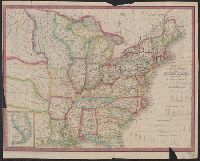
- Creator:
- Burr, Henry A
- Published / Created:
- 1853
- Call Number:
- 75GM 1853
- Container / Volume:
- BRBL_00410
- Image Count:
- 1
- Resource Type:
- Maps, Atlases & Globes
- Description:
- "Engraved by J.M. Atwood. N.Y.", "Showing the proposed routes to the Pacific Ocean.", Relief shown by hachures., and Shows canals, steamboat lines, finished and unfinished railroads.
- Publisher:
- J. Disturnell,
- Subject (Geographic):
- Canada--Maps and United States--Maps
- Subject (Name):
- Disturnell, John, 1801-1877
- Subject (Topic):
- Railroads--Canada--Maps and Railroads--United States--Maps
- Found in:
- Beinecke Rare Book and Manuscript Library > Disturnell's new map of the United States and Canada : showing all the canals, rail roads, telegraph lines and principal stage routes / Drawn by Henry A. Burr.

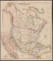
- Creator:
- Burr, Henry A
- Published / Created:
- 1850
- Call Number:
- 75 1850
- Container / Volume:
- BRBL_00400
- Image Count:
- 2
- Resource Type:
- Maps, Atlases & Globes
- Alternative Title:
- Carl I. Wheat map collection. CU-BANC and New map of the United States and Canada
- Description:
- Covers southern Canada, including New Brunswick, Prince Edward Island, and Nova Scotia., Inset: Map of Oregon, California, New Mexico & c. [continuation of main map, 1:10,600,000], and Main map extends west to cover most of Montana, Wyoming, Colorado, most of N
- Publisher:
- Published by J. Disturnell,
- Subject (Geographic):
- Canada--Maps and United States--Maps
- Subject (Name):
- Atwood, John M., b. ca. 1818 and Disturnell, John, 1801-1877
- Subject (Topic):
- Railroads--United States--Maps
- Found in:
- Beinecke Rare Book and Manuscript Library > Disturnell's new map of the United States and Canada : showing all the canals, rail roads, telegraph lines and principal stage routes / drawn by Henry A. Burr, topographer to the Post Office Dep't., Washington, D.C. ; engraved by J.M. Atwood, N.Y.
- Creator:
- Smith, J. Calvin (John Calvin)
- Published / Created:
- 1850
- Call Number:
- 71 1850A
- Container / Volume:
- BRBL_00370
- Image Count:
- 1
- Resource Type:
- Maps, Atlases & Globes
- Description:
- Includes tables of distances for overland routes and sea routes., Inset: Map of the gold region California. Scale [ca. 1:4,752,000]., Prime meridian: Washington, D.C., and Relief shown by hachures.
- Publisher:
- J. Disturnell,
- Subject (Geographic):
- North America--Maps
- Subject (Name):
- Disturnell, John, 1801-1877
- Found in:
- Beinecke Rare Book and Manuscript Library > Map of North America / by J. Calvin Smith.
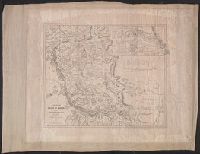
- Published / Created:
- 1847
- Call Number:
- 88 M57 1847A
- Container / Volume:
- BRBL_00647
- Image Count:
- 1
- Resource Type:
- Maps, Atlases & Globes
- Alternative Title:
- Map of the route between Vera Cruz, Alvarado & Puebla.
- Description:
- "Entered according to act of Congress in the year 1847 by John Disturnell in the clerks of, Includes "Profile of the route between Mexico and Vera Cruz" and "Map of the route between Vera Cruz, Alvarado & Puebla.", and Relief shown by hachures and spot heights.
- Publisher:
- J. Disturnell,
- Subject (Geographic):
- Mexico, Valley of (Mexico)--Maps
- Subject (Name):
- Disturnell, John, 1801-1877
- Found in:
- Beinecke Rare Book and Manuscript Library > Map of the Valley of Mexico and the surrounding mountains.
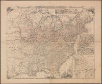
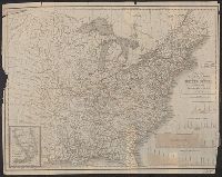
6.
- Creator:
- Tanner, Henry Schenck, 1786-1858
- Published / Created:
- 1840
- Call Number:
- 75gm 1840C
- Container / Volume:
- BRBL_00410
- Image Count:
- 1
- Resource Type:
- Maps, Atlases & Globes
- Description:
- "Entered according to Act of Congress in the year 1839, by H.S. Tanner of the state of Pennsylvania.", Canals are shown in red and yellow. Railway lines shown in blue; proposed lines in green., Copy with canals, railroads colored, and borders colored., and Inclu
- Publisher:
- T.R. Tanner & J. Disturnell,
- Subject (Geographic):
- United States--Maps.
- Subject (Name):
- Disturnell, John, 1801-1877 and Knight, J. (Jonathan), 1787-1858
- Subject (Topic):
- Canals--United States--Maps. and Railroads--United States--Maps.
- Found in:
- Beinecke Rare Book and Manuscript Library > Map of the canals & rail roads of the United States / reduced from the large map of the U.S. by H.S. Tanner ; engraved by J. Knight.
7.
- Creator:
- Tanner, Henry Schenck, 1786-1858
- Published / Created:
- 1840
- Call Number:
- 75gm 1840B
- Container / Volume:
- BRBL_00410
- Image Count:
- 1
- Resource Type:
- Maps, Atlases & Globes
- Description:
- "Entered according to Act of Congress in the year 1839, by H.S. Tanner of the state of Pennsylvania.", Canals are shown in red and yellow. Railway lines shown in blue; proposed lines in green., Copy with canals and railroads colored., and Includes 4 canal cross
- Publisher:
- T.R. Tanner & J. Disturnell,
- Subject (Geographic):
- United States--Maps.
- Subject (Name):
- Disturnell, John, 1801-1877 and Knight, J. (Jonathan), 1787-1858
- Subject (Topic):
- Canals--United States--Maps. and Railroads--United States--Maps
- Found in:
- Beinecke Rare Book and Manuscript Library > Map of the canals & rail roads of the United States / reduced from the large map of the U.S. by H.S. Tanner ; engraved by J. Knight.