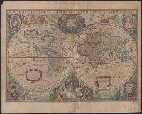
Nova totivs terrarvm orbis geographica ac hydrographica tabvla
Description:
Appears in Jan Jansson's Appendix novi Atlantis (1637) and Jan Jansson and Hendrik Hondius's Atlas novus (1638)., Double hemisphere on sheet, with portraits of Ptolemy, J. Hondius, Caesar and Mercator., Relief shown pictorially., and With dedication to David Sanclarus, Antonius de Willon and Martinius by Hendrik Hondius, dated 1630.
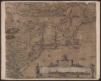
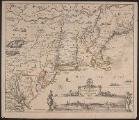
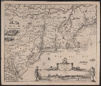
Inset view: Nieuw Amsterdam op t eylant Manhattans., Mounted on paper backing. Sheet measures 47.1 x 56 cm. Cross Collection no. 181., and Relief shown pictorially.
Publisher:
s.n.,
Subject (Geographic):
Middle Atlantic States--Maps--Early works to 1800 and New England--Maps--Early works to 1800
Copy 1: 47 x 56 cm., on sheet 51 x 59 cm. Stamp on verso: Yale Horace Brown 1900 S. Ms. title on verso: Neu Holland & Neu Engelland & Virginien. Ms. no. on verso: 397., Inset view: Nieuw Amsterdam op t eylant Manhattans., and Relief shown pictorially.
Publisher:
s.n.,
Subject (Geographic):
Middle Atlantic States--Maps--Early works to 1800 and New England--Maps--Early works to 1800
"Cum Privil.", Appeared in Peter Schenk's Atlas contractus., Backed with paper. Ms. no. "47" in lower-right corner. Sheet measures 62.5 x 53.7 cm. No. 44 of 87 maps bound together., Includes four bar scales., Prime meridian: Ferro., and Relief shown pictorially.
Publisher:
Peter Schenk],
Subject (Geographic):
Scotland--Maps--Early works to 1800.
Subject (Name):
Schenk, Peter, 1660-1718 or 1719. Atlas contractus.
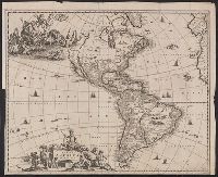
Appears in Arnoldus Montanus's Nieuwe en onbekende weereld ... t' Amsterdam : J. Meurs, 1671., Based on Nicolaes Visscher's map of the same title., Label on verso [with ms. nos.]: 559/123. Sheet measures 45.5 x 56 cm. Cross Collection no. 123., Relief shown pictorially., Shows California as an island., and Title cartouche in lower left; illustration of Neptune in upper left.
Publisher:
Jacob van Meurs,
Subject (Geographic):
America--Maps--Early works to 1800 and Western Hemisphere--Maps--Early works to 1800
Subject (Name):
Montanus, Arnoldus, 1625?-1683. Nieuwe en onbekende weereld
1st state. Distinguishing characteristic of 1st state: "Lacking a privilege" (Burden 431)., Date of map dispute, Published separately; also appears in altases by Visscher and Jansson (Burden 430-431)., Relief shown pictorially., and Shows California as an island.
Publisher:
s.n.,
Subject (Geographic):
America--Maps--Early works to 1800 and Western Hemisphere--Maps--Early works to 1800
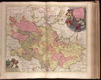
"Cum Privil. Ordin. Gen. Belg. Foed.", Appeared in Peter Schenk's Atlas contractus [ca. 1700]., Backed with paper. Ms. no. "33" in upper-right corner. Sheet measures 53.5 x 62.7 cm. No. 32 of 87 maps bound together., Bar scales given in "milliaria Germanica" and "milliaria Gallica"., Dedication: Sereniss. ac Potentissimo Dn. Dn. Iohanni Guilielmo Dg. Com. Palat. Rhen. S. R. I. Archithesaur. et Elect. Bavar. Iul. Cliv. ac Mont. Duc. etc. etc. Princ. ac Domino suo clementissimo hanc Palatinatus Rhen. Tabulam submisse dicat et consecrat., Prime meridian: Ferro., Relief shown pictorially., and Watermark.
Publisher:
Peter Schenk,
Subject (Geographic):
Baden-Württemberg (Germany)--Maps--Early works to 1800., Hesse (Germany)--Maps--Early works to 1800., and Rhineland-Palatinate (Germany)--Maps--Early works to 1800.
Subject (Name):
Schenk, Peter, 1660-1718 or 1719. Atlas contractus.
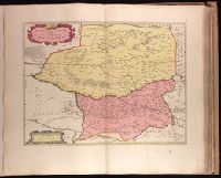
Petrocorivm comitatvs vulgo la comtée de Périgort
Description:
Backed with paper. Ms. no. "56" in upper-right corner. Sheet measures 53.8 x 63.4 cm. No. 51 of 87 maps bound together., Bar scales given in "lieues Francoises" and "milliaria Germanica communia"., Prime meridian: Ferro., Relief shown pictorially., and Watermark.
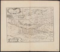
Petrocorivm comitatvs vulgo la comtée de Périgort
Description:
Bar scales given in "lieues Francoises" and "milliaria Germanica communia"., Imperfect: partially torn alon, In Latin on verso, with caption title "Petrogoriense Territorium vulgò Perigord" and signature 3N., Prime meridian: Ferro., and Relief shown pictorially.