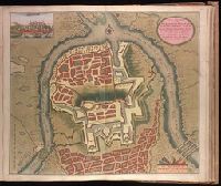
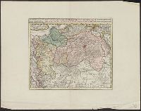
Backed with paper. Ms. no. "79" in upper right-hand corner. Sheet measures 53.6 x 62.5 cm. No. 73 of 87 maps bound together., Bar scale given in "Schaale van 200 Klaffter Turckse Maet.", Relief shown pictorially., and With inset bird's-eye view of Belgrade in upper left corner.
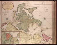
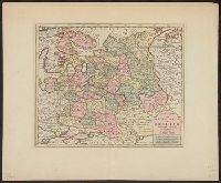
"Met previlegie.", Appeared in Gerard van Keulen's Nieuwe groote ligtende Zee-Fakkel ... 1734; cf. Koeman, C. Atlantes Neerlandici, IV, Keu 45, map 26., Backed with paper. Ms. no. "13" in upper right-hand corner. Sheet measures 53.6 x 62.8 cm. No. 12 of 87 maps bound together., Bar scale given in "Duytsche Mylen"., Includes inset map: De stad Straalsund / L. v. Ansée s., Relief shown pictorially; depths shown by soundings., and Watermark.
Publisher:
By Gerard van Keulen ...,
Subject (Geographic):
Rügen Island (Germany)--Maps--Early works to 1800. and Stralsund (Germany)--Maps--Early works to 1800.
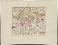
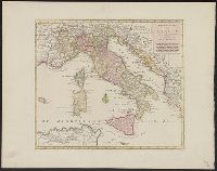
Backed with paper. Ms. no. "66" in upper right-hand corner. Sheet measures 53.7 x 62.3 cm. No. 61 of 87 maps bound together., Includes four bar scales., Relief shown pictorially; depths shown by soundings., and With north oriented to the left.
Publisher:
By Gerard van Keulen, aen de nieuwe Brug met privilegie,
Subject (Geographic):
Sardinia (Italy)--Maps--Early works to 1800.
Subject (Topic):
Nautical charts--Mediterranean Sea--Early works to 1800.
Keulen, Gerard van Keulen, Johannes van, fl. 1726-1753. Nieuwe groote lichtende zee-fakkel
Call Number:
303cea 1680
Container / Volume:
BRBL_00033
Image Count:
1
Resource Type:
Maps, Atlases & Globes
Alternative Title:
New sea map of the whole North Sea and Nouvelle carte marine generale de la Mer du Nord
Description:
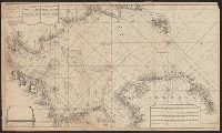
Appeared in Joannes van Keulen's De Nieuwe groote, Backed with paper. Sheets measure 61.0 x 52.2 cm or smaller., Includes five bar scales., Relief shown pictorially; depth shown by soundings., and Scale estimated by measurement of degree of latitude.
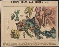
Hadol, Paul, 1835-1875. Carte drôlatique d'Europe pour 1870
Published / Created:
[1870]
Call Number:
30 1870D
Container / Volume:
BRBL_00032
Image Count:
1
Resource Type:
Maps, Atlases & Globes
Description:
Caricature map., Includes text., National political attitudes are represented by caricatures., and Similar to P. Hudol's Carte drôlatique d'Europe pour 1870.
Publisher:
Emrik & Binger,
Subject (Geographic):
Europe--Maps and Europe--Politics and government--Maps
Although the map bears the date of 1755, it was not published until 1769., Dutch edition of Palairet's Carte des possessions angloises & francoises ... [1755]., From Isaak Tirion, and Hand col. Sheet measures 44 x 54 cm. Accompanied by ms. note by Henry Stevens.
Publisher:
By Isaak Tirion,
Subject (Geographic):
North America--Maps--Early works to 1800 and United States--History--French and Indian War, 1755-1763--Maps--Early works to 1800
Subject (Name):
Palairet, Jean, 1697-1774. Carte des possessions angloises & francoises du continent de l'Amerique Septentrionale
Subject (Topic):
British--America--Maps--Early works to 1800 and French--America--Maps--Early works to 1800