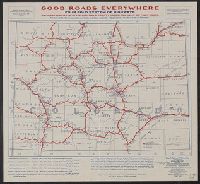
"Four fold system of highways: national highways, state highways, county roads, township or town roads." and "Published under direction of General Coleman du Pont."
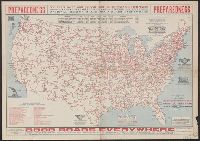
"Issued under the joint auspices of the National Highways Association." and "This map shows tentative locations for a system of 100,000 miles of national highways."
"Published under direction of General Coleman du Pont, Chairman Board of Councillors.", "This map shows tentative locations for a national highways system.", and Includes color coded key to individual highways and ill.
Publisher:
National Highways Association,
Subject (Topic):
Highway planning--United States--Maps and Roads--United States--Maps
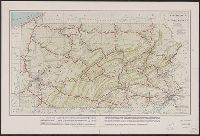
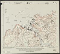
In upper margin: Nemours 1:10,000., Map included on index map to G.S.G.S. 4275., Military grid., and Relief shown by form lines, "interval 20 feet (approximate)."
Publisher:
Army Map Service, U.S. Army,
Subject (Geographic):
Ghazaouet (Algeria)--Maps
Subject (Name):
Great Britain. War Office. General Staff. Geographical Section and United States. Army Map Service
National Geographic Society (U.S.). Cartographic Division
Published / Created:
1986
Call Number:
8101 1986
Container / Volume:
BRBL_00552
Image Count:
2
Resource Type:
Maps, Atlases & Globes
Alternative Title:
Making of America ; no. 13
Description:
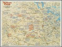
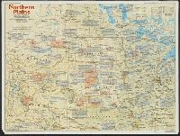
"Supplement to the National Geographic, December 1986, page 786A, vol. 170, no. 6.", Includes historical notes and key to abbreviations., Panel title: The making of America, Northern Plains., Relief shown by shading and spot heights., and Text, col. ill., and 5 m
Publisher:
The Society,
Subject (Geographic):
Great Plains--History--Maps, Great Plains--Maps, Middle West--History--Maps, and Middle West--Maps
National Geographic Society (U.S.). Cartographic Division
Published / Created:
1986
Call Number:
8101 1986
Container / Volume:
BRBL_00552
Image Count:
2
Resource Type:
Maps, Atlases & Globes
Alternative Title:
Making of America ; no. 13
Description:
"Supplement to the National Geographic, December 1986, page 786A, vol. 170, no. 6.", Includes historical notes and key to abbreviations., Panel title: The making of America, Northern Plains., Relief shown by shading and spot heights., and Text, col. ill., and 5 m
Publisher:
The Society,
Subject (Geographic):
Great Plains--History--Maps, Great Plains--Maps, Middle West--History--Maps, and Middle West--Maps
National Geographic Society (U.S.). Cartographic Division
Published / Created:
1960
Call Number:
845 1960
Container / Volume:
BRBL_00620
Image Count:
1
Resource Type:
Maps, Atlases & Globes
Description:
"Atlas plate 11.", Relief shown by shading and spot heights. Depths shown by gradient tints and soundings., and Supplement to April, 1960 issue of the National Geographic magazine.