No. 18 of 43 maps bound together in composite atlas., Reduite d'apres la grande carte pour trouver facilement ce qu'on a envie de chercher dans celle-la., Relief shown pictorially., Scale [ca 1:3,750,000]., Table alphabetique des villes ... qui se trouvent dans cette carte., and With inset map: Morceau detache qui represente l'acroissement des etats de sa majeste le roi de Sardaigne, depuis l'an 1680.
Chart of the northwest coast of America and the northeast coast of Asia, explored in the years 1778 and 1779
Description:
Includes notes., No. 34 of 43 maps bound together in composite atlas., Prepared by Lieut. Heny. Roberts, under the immediate inspection of Capt. Cook ; engraved by W. Palmer., Relief shown pictorially. Depths shown by soundings., and Scale [ca. 1:13,500,000].
Publisher:
Wm. Faden, geographer to the King, Charing Cross
Subject (Geographic):
Bering Strait Region --Discovery and exploration --Maps --Early works to 1800, North America --Discovery and exploration --Maps --Early works to 1800, Pacific Coast (North America) --Discovery and exploration --Maps --Early works to 1800, and Russian Far east (Russia) --Discovery and exploration --Maps --Early works to 1800
Subject (Name):
Cook, James, 1728-1779
Subject (Topic):
Discoveries in geography --Maps --Early works to 1800
Ferro meridian., No. 38 of 43 maps bound together in composite atlas., Relief shown by hachures., Scale [1:1,750,000]., and Shows rivers and settlements.
Subject (Geographic):
Egypt --Maps --Early works to 1800 and Nile River --Maps --Early works to 1800
Kitchin, Thomas, d. 1784, creator Sayer, Robert, 1725-1794
Published / Created:
1787 January 1
Call Number:
1982 Folio 10
Image Count:
2
Description:
Also appeared in Kitchin's General atlas, describing the whole universe. London : Printed and sold for R. Sayer and J. Bennet, 1780., By Thos. Kitchin, hydrographer to the king ; with many additions and improvements from the latest surveys and observations., No. 4 of 43 maps bound together in composite atlas., Pictorial relief., Scale [ca. 1:4,800,000]., and Western part of the northern states including the British Islands, Norway, Denmark and part of Sweden -- Eastern part of the northern states, including the eastern part of Sweden; European Russia, &c. -- Western part of the Mediterranean Sea with the coasts of Spain, France, Italy, Barbary -- Eastern part of the Mediterranean Sea with the coasts of Turky [sic], Anatolia, Syria, Egypt and Barbary.
Publisher:
Robert Sayer
Subject (Geographic):
Africa, North --Maps --Early works to 1800, Europe --Maps --Early works to 1800, and Middle east --Maps --Early works to 1800
Delarochette, L. (Louis), 1731-1802, creator Faden, William, 1749-1836 Meta, C. Palmer, W. (William), 1739-1812
Published / Created:
1790 January 1
Call Number:
1982 Folio 10
Image Count:
1
Description:
Also appeared in Faden's [General atlas. London : William Faden, 1811?]., Includes illustrated cartouche C. Meta fec., No. 28 of 43 maps bound together in composite atlas., Relief shown pictorially., and Scale [ca. 1:1,350,000].
Publisher:
Willm. Faden
Subject (Geographic):
Greece --Maps --Early works to 1800 and Turkey --Maps --Early works to 1800
Anville, Jean Baptiste Bourguignon d', 1697-1782 Aveline, J. A. Coypel, Charles-Antoine, 1694-1752
Published / Created:
1743
Call Number:
1982 Folio 10
Image Count:
2
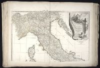
Description:
Also appeared in Anville's [Atlas general. Paris : Jean Baptiste Bourguignon d'Anville, 1771]., Covers also Corsica and Malta., Includes ornamental cartouche drawn and engraved by Coypet and Aveline., No. 17 of 43 maps bound together in composite atlas., Par le Sr. d'Anville ; de la gravure de P. Bourgoin., Relief shown pictorially., and Scale [ca. 1:1,500,000].
Eastern old world hemisphere has imprint: London ... Dec. 1st, 1786 by William Faden., No. 2 of 43 maps bound together in composite atlas., Scale [1:60,000,000]., and Shows western and eastern hemispheres separately.