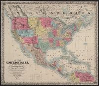
Includes 2 insets, ill., and distance table., Prime meridians: Greenwich and Washington., Relief shown by hachures and spot heights., Shows California's gold region and western trails., and Variant ed. in same year.
Publisher:
J.H. Colton,
Subject (Geographic):
California--Gold discoveries--Maps, North America--Maps, and United States--Maps
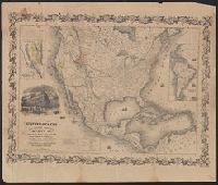
"Entered according to act of Congress in the year 1849 by J.H. Colton ....", "Printed at Ackermans r[ooms 120?] Fulton St. N.Y.", Includes 2 insets, ill., and distance table., Prime meridians: Greenwich and Washington., and Relief shown by hachures and spot heigh
Publisher:
J.H. Colton,
Subject (Geographic):
California--Gold discoveries--Maps, North America--Maps, and United States--Maps
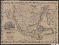
Entered according to act of Congress in the year 1848 by Ensign's & Thayer in the clerk's office of the District court of the southern district of New York., Ornamental pictorial border., and Prime meridian: Washington, D.C.
Publisher:
Ensign, Bridgman & Fanning,
Subject (Geographic):
Mississippi River Valley--Maps and Northwest, Old--Maps
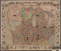
Ensigns & Thayer's map of the western states, Ensigns & Thayer's travellers' guide through the states of Ohio, Michigan, Indiana, Illinois, Missouri, Iowa, and Wisconsin., and Travellers' guide through the states of Ohio, Michigan, Indiana, Illinois, Missouri,
Description:
Accompanied by text: Ensigns & Thayer's travellers' guide through the states of Ohio, Michigan, Indiana, Illinois, Missouri, Iowa, and Wisconsin; with railroad, canal, stage, and steamboat route, accompanied with a new map of the above states. 32 p. ; 14 cm., Includes city vignettes in margins., and Library's copies of text and map are stored separately. See "Covers *80 1848C" for text and "*80 1848C" for map.