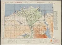
Egypt. Maṣlaḥat al-Misāḥah, cartographer, issuing body
Published / Created:
1909-
Call Number:
61 1909
Container / Volume:
BRBL_00764
Image Count:
6
Resource Type:
Maps, Atlases & Globes
Description:
Cultivated land shown in color., DLC, Relief shown by form lines and spot heights., Sheet 1. Alexandria -- Sheet 2. Cairo -- Sheet 3. Western Oases -- Sheet 4. Eatern Desert -- Sheet 5., Some LC copies mounted on cloth backing., and Various issues of some sheets.
"This sheet is gridded with 'red' grid based on Long. 31° E.", English and Arabic., Geographic coverage of E, Includes index to adjoining sheets and "List of permanent water supplies.", Map no. A384., and Relief shown by gradient tints, hachures, and spot heights.
Ferro meridian., No. 38 of 43 maps bound together in composite atlas., Relief shown by hachures., Scale [1:1,750,000]., and Shows rivers and settlements.
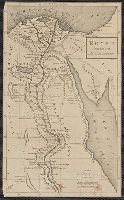
Subject (Geographic):
Egypt --Maps --Early works to 1800 and Nile River --Maps --Early works to 1800
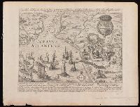
Hogenberg, Frans, approximately 1539-1590, creator
Published / Created:
[1612?]
Call Number:
BrSides 2019 69
Image Count:
1
Resource Type:
Maps, Atlases & Globes
Alternative Title:
Eigentliche abbildung der Starken Vestung La'rache ein furnhemer Meerhaven in Barbarien, welche, in Nahmen Königlicher Majest. von Hispanien durch den Marckgraven von S.Germein ist eingenomen worden Ao. 1610 im Nove[m]b
Description:
Four lines of verse in two columns in Latin and four lines of verse in two columns in German in lower margin, with explanatory text below., North oriented towards the left., Relief shown pictorially., Removed from Georg Braun's Civitates orbis terrarum., and Watermark.
Publisher:
[Georg Braun and Franz Hogenberg],
Subject (Geographic):
Larache (Morocco)--Maps--Early works to 1800.
Subject (Name):
Braun, Georg, 1540 or 1541-1622. Civitates orbis terrarum and Hogenberg, Abraham, active 1608-1653, printer